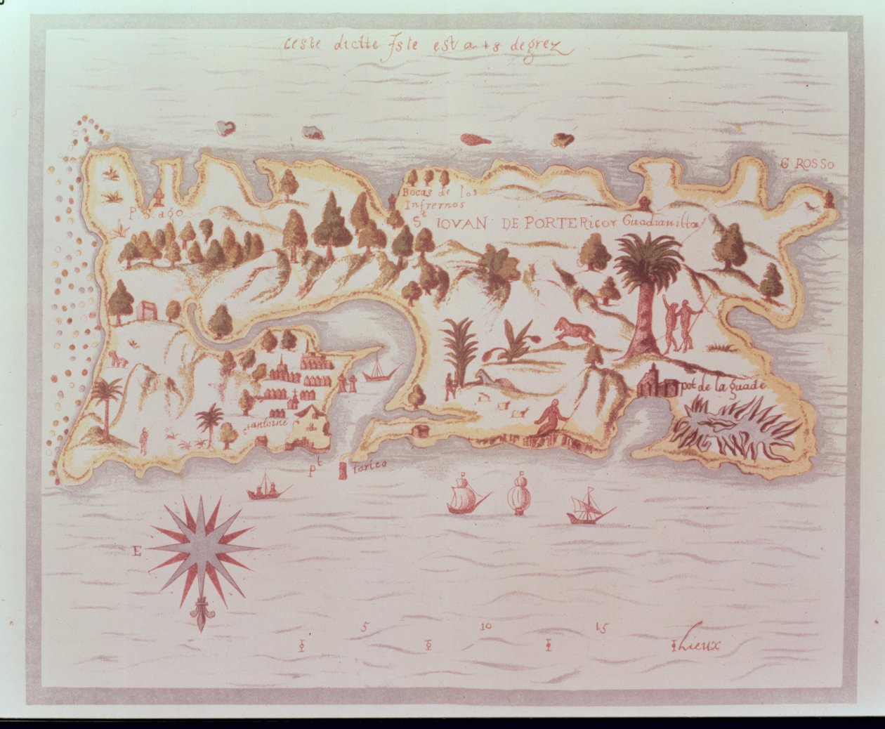
Map of the Island of Puerto Rico, 1599 by Samuel de Champlain

Map of the Island of Puerto Rico, 1599

(Map of the island of Puerto Rico, 1599)


Samuel de Champlain

€ 110.72
Enthält 0% MwSt.
   Configure art print
1599  ·  vellum  ·  Picture ID: 54499

Nonclassified artists  ·  Cartography

Map of the Island of Puerto Rico, 1599 by Samuel de Champlain. Available as an art print on canvas, photo paper, watercolor board, uncoated paper or Japanese paper.
cabo rojo · 18 degrees · trees · boar · natives · hunting · upside down see compass · caribbean · Royal Commonwealth Society, London, UK / Bridgeman Images
AR/3D   View in 3D / AR zu Favoriten hinzufügen   Add to favorites    Select wall color    View painting in a room
0 Reviews

Configure art print

Picture Frame

Medium & Stretcher

Glass & Passepartout

Miscellaneous & Extras

 Save / compare configuration
Preview Icon

Summary

Gemälde
Veredelung
Keilrahmen
Museumslizenz

€ 110.72
(inkl. 20% MwSt)
   Add to cart

Bildschärfe: PERFEKT

Should you desire adjustments to brightness and color, or a custom crop of the motif, we are happy to make these changes at no additional cost to you. Please do not hesitate to contact us.

Similar artworks selected for you

Map of the Island of Martinique, 1599 View of the Strait of Gibraltar and Surroundings, with the Trenches of the Siege in 1704 Donegal and Sligo Bays, Ireland, c.1600 Coasts of Mozambique from The East Indies View of the Siege of Gibraltar in 1704 Chart of Milford Haven in St Georges and Bristol Channel Richard Grenville’s plan of Tintagel, c.1583 Louis XIV Atlas, map of Collioure San Miguel St Augustine French Guiana, South America Mozambique Map of Rhode Island at the time of its occupation 1780-81 by the French Army on the orders of Jean-Baptiste de Vimeur Count of Rochambeau Map of Rhode Island, from Augustine from Drakes West Indian Voyage 1585 - 86 Siege of Malta (detail) Pascatway River in New England, c.1660-85 Map of part of New Spain, the coast of Peru and the city of Lima, from "Mapas de las costas de América en el mar del Sur, desde la última población de españoles en ellas, que es la ciudad de Compostela, en adelante" A Map of the Country and City of Panama. Part. 3 : Chap : 5. (engraving) City of Goa in India, Engraving by Theodor de Bry from Travel account of the voyage of the sailor Jan Huyghen van Linschoten to Portuguese East India 1579-1592 Map Depicting the Destruction of the Spanish Colony of St. Augustine in Florida on 7th July 1586 by the English Fleet Commanded by Sir Francis Drake Cartegena, from Drake Bristol Channel Map of Rhode Island at the time of its occupation 1780-81 by the French Army on the orders of Jean-Baptiste de Vimeur Count of Rochambeau A Correct Draught of the Harbours of Port Royal and Kingston, with the Keys and Shoals Adjacent &c. from a Late Accurate Survey, by Mr. Richd Jones, Engineer Sofala, Mozambique Geographic Map of the Azores Map of the St. Lawrence Estuary Part of a panoramic map of the coast from Land
Show more similar artworks

Other art prints by Samuel de Champlain

The first French settlement at Quebec, early 17th Century Map of the Island of Martinique, 1599 Illustrations of Algonquin Dress, Engraving from Voyages of Sieur de Champlain by Samuel de Champlain, 17th Century Champlain West Indies Plate LX - Story of the Indians Map of the Island of Puerto Rico, 1599 Champlain West Indies Plate LXI - Story of the Indians Illustrations of Algonquin dress, engraving from Voyages of Sieur de Champlain by Samuel de Champlain Champlain West Indies Plate LIX - Story of the Indians The Inquisition in New Spain
Discover more works by Samuel de Champlain

Other motives from the category Cartography

Renaissance map of Europe, Jacopo Russo (after) 1528 Europe and Central Asia, from an Atlas of the World in 33 Maps, Venice, 1st September 1553 Map of the County of Middlesex, published 1819 Map of the Kingdom of Hungary and the States which are United to its Crown, pub. by Jan Barend Elwe, Amsterdam, 1742 Map of Siberia Showing the Immense Natural Resources of the Area and Depicting a Sea Route Which Would Open Up Trade, 1933 The City of Jerusalem and the Surrounding Area, Detail from the Madaba Mosaic Map Map of the world with possessions of the British Empire coloured red, c.1870 Map of Korea Map of the Holy Land in Old Testament Times by Mons l A New and Correct Map of the Trading Part of the West Indies Map of the Austrian Empire Map of India, published under the direction of Colonel H.R. Thuillier, R.E., Surveyor General of India, 1882 Map of Laputa (flying island top right) and Balnibarbii (main port Maldonada) from Part III: A Voyage to Laputa, Balnibarbi, Luggnagg, Glubbdubdrib, and Japan in Gulliver Map of the Southern Hemisphere, from Map of Messina, from
View More from "Cartography"

Excerpt from our top sellers

White-Bear-King-Valemon The Swing Standing Girl Old Woman and Boy with Candles The Hay Wain The Chocolate Girl (La Belle Chocolatière de Vienne) Chalk Paths Alley in Arles with Houses The Garden of Earthly Delights Circe Offering the Cup to Ulysses, 1891 Lilith Cupid as Victor Isle of the Dead Portrait of a Lady The Embrace
Show More Artworks


What our customers think about us


Frequently Asked Questions about Meisterdrucke


Personalizing your art print at Meisterdrucke is a simple and intuitive process that allows you to design an artwork exactly to your specifications: Choose a frame, determine the image size, decide on a printing medium, and add suitable glazing or a stretcher frame. We also offer customization options such as mats, fillets, and spacers. Our customer service is available to help you design your perfect artwork.

At Meisterdrucke, you have the fascinating option to visualize the artwork you configured directly in your own space. For a tailored preview, simply upload a photo of your room and let the artwork appear on it. If you visit us via a mobile device, be it a phone or tablet, our augmented reality feature brings the image to life and seamlessly projects it into your space. An experience that uniquely combines art and technology.

Choosing the medium is often a matter of personal taste. To give you a clearer idea, we have provided some images for each medium. For a holistic experience, we also offer you a sample set of all paper variants so you can make a decision not just visually but also haptically. You can take advantage of the sample set free of charge – only the shipping costs will apply. You can order the sample set directly.

Do not worry. At Meisterdrucke, we do not proceed mechanically. We manually review each order. If there are any inconsistencies or peculiarities in the configuration, we will immediately contact you. Of course, our courteous and patient support is always at your side to assist you with the configuration. Together with you, we adjust your image by phone or email so that the final result exactly meets your expectations.


Do you have any questions?

Are you interested in an art print from our manufactory but still unsure? Do you need advice on choosing the medium or help with the order?

Our experts are happy to assist you.

+43 4257 29415
support@meisterdrucke.com
Mo-Do: 7:00 - 16:00 | Fr: 7:00 - 13:00

Do you have any questions?

Are you interested in an art print from our manufactory but still unsure? Do you need advice on choosing the medium or help with the order?

Our experts are happy to assist you.

+43 4257 29415
support@meisterdrucke.com
Mo-Do: 7:00 - 16:00 | Fr: 7:00 - 13:00


Meisterdrucke

   Kärntner Strasse 46
        9586 Finkenstein am Faaker See
        Austria
        +43 4257 29415
        support@meisterdrucke.com
Other languages

                   
Erfahrungen & Bewertungen zu Meisterdrucke
Post.at DHL Express Quehenberger Cargoboard
Kaiser Franz Joseph

Meisterdrucke
Kärntner Strasse 46
9586 Finkenstein am Faaker See · Austria
+43 4257 29415 · office@meisterdrucke.com
Post.at DHL Express Quehenberger Cargoboard


Meisterdrucke 2717 Bewertungen auf ProvenExpert.com

(c) 2025 meisterdrucke.us