Search by artist, work title or style – e.g. Monet, Starry Night, Impressionism, Hokusai wave, nude. Describe the scene – e.g. green meadow, abstract with lots of red, dark oil painting, standing nude next to a tree.

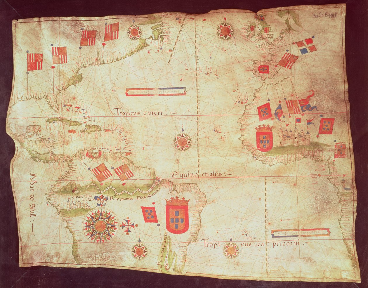
Map of the Atlantic Ocean, c.1550 by Portuguese School

Map of the Atlantic Ocean, c.1550

(Map of the Atlantic Ocean, c.1550 )


Portuguese School

€ 117.77
Enthält 0% MwSt.
   Configure art print
Undated  ·  vellum  ·  Picture ID: 100247

Cultural Circles  ·  Cartography

Map of the Atlantic Ocean, c.1550 by Portuguese School. Available as an art print on canvas, photo paper, watercolor board, uncoated paper or Japanese paper.
carte de locean atlantique · tropic of cancer · capricorn · equator · great britain · africa · south america · flag · coat of arms · national · Bibliotheque Nationale, Paris, France / Bridgeman Images
AR/3D   View in 3D / AR zu Favoriten hinzufügen   Add to favorites    Select wall color    View painting in a room
0 Reviews

Configure art print

Picture Frame

Medium & Stretcher

Glass & Passepartout

Miscellaneous & Extras

 Save / compare configuration
Preview Icon

Summary

Gemälde
Veredelung
Keilrahmen
Museumslizenz

€ 117.77
(inkl. 20% MwSt)
   Add to cart

Bildschärfe: PERFEKT

Should you desire adjustments to brightness and color, or a custom crop of the motif, we are happy to make these changes at no additional cost to you. Please do not hesitate to contact us.

Similar artworks selected for you

Portulan Chart of the Atlantic Ocean, Mediterranean and Black Sea, c.1535 Chart of the Atlantic Ocean, Mediterranean and Black Sea, c.1535 Map of Persia, Arabia and India, from an atlas, 1571 Portolan Chart of Western Europe and North Africa Chart of Mediterranean and North East Atlantic Portolan Chart of Western Europe and North Africa Map of Europe, Asia Minor, and Africa, as far south as Cape Rosso, vellum Chart of North-East Atlantic, from British Isles to Cape Verde Nautical Chart of Mediterranean Area, Including Europe with British Isles and Part of Scandinavia Portulan of the Atlantic and Pacific A Portolan Chart of the Atlantic Ocean and Adjacent Continents The Aegean Sea, from a Nautical Atlas, 1646 A Mediterranean Chart Showing the North East Atlantic The entire Mediterranean Basin, from a nautical chart Islands of Central America, nautical chart Miniature Nautical Map of the Central Mediterranean, 1560 The Coast of Turkey and Cyprus, from a Nautical Atlas of the Mediterranean and Middle East The Eastern Mediterranean, from a nautical atlas, 1520 Map of Great Britain, Europe and North West Africa, from Portugaliae Monumenta Cartographica, an Account of the Discoveries of Fernao Gomez from 1470-75 Nautical Chart of the Mediterranean Sea and the Black Sea World map on vellum, c.1540 Chart of Arabia and the Eastern Mediterranean, Part of a Portolan Atlas, c.1650 Aegean Sea, from Portolan Atlas Consisting of Six Charts The Aegean Sea, from a Nautical Atlas, 1651 Planisphere of Cantino: Map of Alberto Cantino from 1502 representing the boundary line imposed by the Treaty of Tordesillas (1494) between Portuguese and Spanish America. Biblioteca Estense, Modena Map of the Mediterranean Sea HM 1549, Luís Teixeira, Portolan Chart. Lisbon, ca. 1600 A Nautical Map, 1564 Chart of Mediterranean, Black and Caspian Seas, c.1620
Show more similar artworks

Other art prints by Portuguese School

Portrait of John II of Portugal Brazil from the Vasco da Gama Portrait of Luis Vaz de Camoes Ferdinand Magellan Measuring instrument: 16th century Portuguese nautical astrolabe Representation of the Pregnant Virgin with a Hand on Her Belly Pedro Alvares Cabral (c.1467-c.1520) Arriving in Brazil in 1500, from The Tomb of Ines de Castro (d.1355) Panoramic view of Lisbon before the earthquake of 1755 Portulan of the West Coast of Africa with the Canary Islands The Chicken Gargoyle of a sea monster Conquest of Africa: The capture of Asilah (Arzila) in Morocco in 1471 by the Portuguese fleet Warships. Memories of the Armadas of Portugal Under King Manuel I (1469 - 1521)
Discover more works by Portuguese School

Other motives from the category Cartography

Map of the Southern Hemisphere, from Map of the Battle of Marengo Map from De La Situation du Paradis Terrestre, 1691 Map of the World, Jerusalem and Damascus (detail) from a Renaissance map of Europe, 1528 Cartouche from a Map of the Cevennes Region, 1703 Map of the world Map of Fredericksburg, December 1862 Map of Britain in 640, from The Northumbrian Kingdom in Map of the City of Ancient Rome During Its Greatness, BC 30-AD 400 Map of Herefordshire, 1695 A Section of a Map of Milan Map of Asia, from the Map of Sixteenth Century Japan (from the Captain Boyton Exhibiting the Swimming Apparatus
View More from "Cartography"

Excerpt from our top sellers

The Birth of Venus The Roses, 1925-26 Little Oak Tree Noon, or The Siesta (after Millet) Stein on the Danube (District of Krems) Three Sunflowers Portrait of Joan of Arc with flag and lilies on the background of Notre Dame Cathedral Madonna of the Yarnwinder View across the Sawahs to Gunung Agung The Langlois Bridge at Arles with Washerwomen The Seasons: Summer, 1896 Spruce Thicket in the Snow Reclining Nude Neptune Tilla Durieux as Circe
Show More Artworks


What our customers think about us


Frequently Asked Questions about Meisterdrucke


Personalizing your art print at Meisterdrucke is a simple and intuitive process that allows you to design an artwork exactly to your specifications: Choose a frame, determine the image size, decide on a printing medium, and add suitable glazing or a stretcher frame. We also offer customization options such as mats, fillets, and spacers. Our customer service is available to help you design your perfect artwork.

At Meisterdrucke, you have the fascinating option to visualize the artwork you configured directly in your own space. For a tailored preview, simply upload a photo of your room and let the artwork appear on it. If you visit us via a mobile device, be it a phone or tablet, our augmented reality feature brings the image to life and seamlessly projects it into your space. An experience that uniquely combines art and technology.

Choosing the medium is often a matter of personal taste. To give you a clearer idea, we have provided some images for each medium. For a holistic experience, we also offer you a sample set of all paper variants so you can make a decision not just visually but also haptically. You can take advantage of the sample set free of charge – only the shipping costs will apply. You can order the sample set directly.

Do not worry. At Meisterdrucke, we do not proceed mechanically. We manually review each order. If there are any inconsistencies or peculiarities in the configuration, we will immediately contact you. Of course, our courteous and patient support is always at your side to assist you with the configuration. Together with you, we adjust your image by phone or email so that the final result exactly meets your expectations.


Do you have any questions?

Are you interested in an art print from our manufactory but still unsure? Do you need advice on choosing the medium or help with the order?

Our experts are happy to assist you.

+43 4257 29415
support@meisterdrucke.com
Mo-Do: 7:00 - 16:00 | Fr: 7:00 - 13:00

Do you have any questions?

Are you interested in an art print from our manufactory but still unsure? Do you need advice on choosing the medium or help with the order?

Our experts are happy to assist you.

+43 4257 29415
support@meisterdrucke.com
Mo-Do: 7:00 - 16:00 | Fr: 7:00 - 13:00


Meisterdrucke

   Kärntner Strasse 46
        9586 Finkenstein am Faaker See
        Austria
        +43 4257 29415
        support@meisterdrucke.com
Other languages

                   
Erfahrungen & Bewertungen zu Meisterdrucke
Post.at DHL Express Quehenberger Cargoboard
Kaiser Franz Joseph

Meisterdrucke
Kärntner Strasse 46
9586 Finkenstein am Faaker See · Austria
+43 4257 29415 · office@meisterdrucke.com
Post.at DHL Express Quehenberger Cargoboard


Meisterdrucke 2736 Bewertungen auf ProvenExpert.com

(c) 2025 meisterdrucke.us