support@meisterdrucke.com  ·  0043 4257 29415

Deutsch English Italiano Español Français Nederlands Português Svenska Polski Dansk
Search by artist, work title or style – e.g. Monet, Starry Night, Impressionism, Hokusai wave, nude. Describe the scene – e.g. green meadow, abstract with lots of red, dark oil painting, standing nude next to a tree.

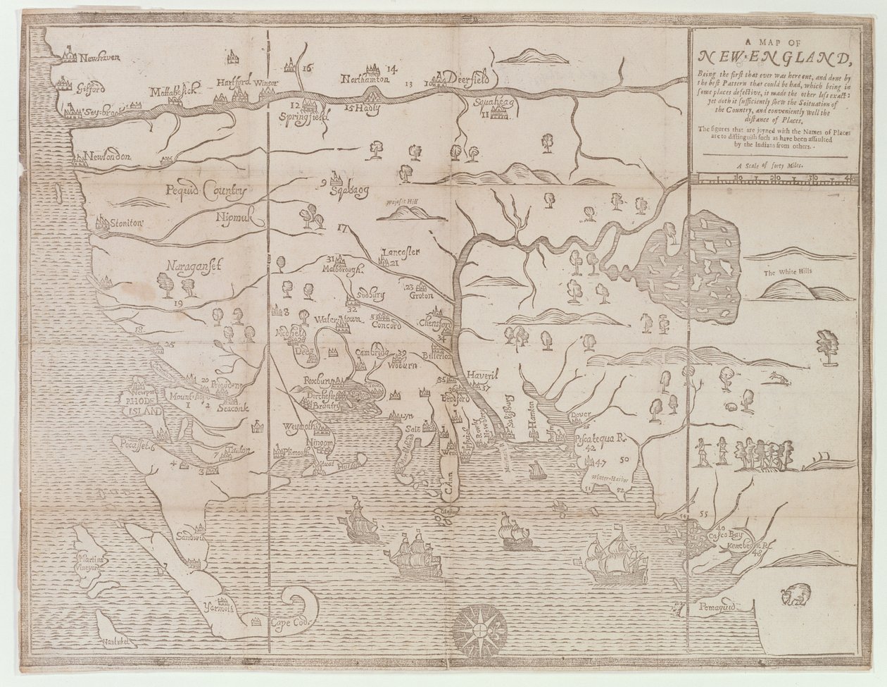
’Map of New England, Being the first that ever was here cut...’, 1677 by John Foster

’Map of New England, Being the first that ever was here cut...’, 1677

('Map of New England, Being the first that ever was here cut...', 1677 )


John Foster

€ 124.71
Tax-free
   Configure art print
1677  ·  woodcut  ·  Image ID: 223682

Nonclassified artists  ·  Cartography

’Map of New England, Being the first that ever was here cut...’, 1677 by John Foster. Available as an art print on canvas, photo paper, watercolor board, natural paper, or Japanese paper.
east coast of america · boston · cape cod · newport · new london · massachusetts · connecticut · rhode island · new hampshire · Massachusetts Historical Society, Boston, MA, USA / Bridgeman Images
Other color versions of this image  
AR/3D   View in 3D / AR zu Favoriten hinzufügen   Add to favorites    Change wall color    View picture in a room
0 Reviews

Configure art print

Picture Frame

Medium & Stretcher

Glass & Passepartout

Miscellaneous & Extras

 Save / compare configuration
Preview Icon

Summary

Gemälde
Veredelung
Keilrahmen
Museumslizenz

€ 124.71
(inkl. 20% MwSt)
   Add to cart

Bildschärfe: PERFEKT

If you'd like us to adjust the brightness, colors, or crop the image, we're happy to do this for you at no extra cost. Just get in touch!

Similar artworks selected for you

Siege of Saint-Omer Valloton A Map of the Country and City of Panama. Part. 3 : Chap : 5. (engraving) Map of the Battle of Landen The Principality of Orange and Comtat Venaissin Map of Northern Norway with Enlarged Sections of Vardø and Kildin by Willem Barents Plan of the Glorious Action Near Pultawa in Ukraine Between the Armies of Tsar Peter the Great of Russia and King Charles XII of Sweden, June 27 - July 8, 1709 A coloured chart of Plymouth Harbour, and of the country up to Tavistock; drawn possibly by Robert Spry Map of Chile Compiled by Jesuits Project for the construction of a channel of communication between the Atlantic Ocean and the Mediterranean Sea, including part approximately between Toulouse and Pexiora; in the regions of Midi-Pyrenees and Languedoc-Roussillon, France French Guiana, South America Project for the construction of a channel of communication between the Atlantic ocean and the Mediterranean sea, inclusive part approximately between Capestang and Étang de Thau; in the regions of Languedoc-Roussillon, France Connecticut Louis XIV Atlas, map of Collioure Map of the Canal du Midi, with its aqueducts Battle of Ter won by the King City of Goa in India, Engraving by Theodor de Bry from Travel account of the voyage of the sailor Jan Huyghen van Linschoten to Portuguese East India 1579-1592 Speculum Romanae Magnificentiae: Ancient Rome, and its Hills, from the West, 1582 Allegorical Map of the Stages of Love 1646 Map of the Western Mediterranean and Gibraltar by Robert Dudley Chart of the North Sea dedicated to True Design of the Great Victory Against the Turkish Fleet, May 15, 1649 Toulon, France The English Victory Against the Scots at Muskelbroghe, 1547 The Battle of Pinkie, c.1547-48 Map of Toulon (France) Map of the Canal du Midi, with its aqueducts
Show more similar artworks

More art prints by John Foster

’Map of New England, Being the first that ever was here cut...’, 1677 The Map of New England from William Hubbard Temple of Jupiter, Athens The Temple of Apollo Epicurius at Bassai, Phigalea Temple of Theseus, Athens The East End and South Side of the Parthenon, c.1813 Richard Mather, first in a line of New England Puritan clergymen and leader of New England Congregationalism General View of the Temple of Apollo Epicurius at Bassai, Phigalea The East End and South Side of the Parthenon The Hippodrome, Constantinople Smyrna
Show more works by John Foster

More motifs from the category Cartography

Map describing the islands of Salvador, Española, Fernanda, Isabella and Conception, 1493 Map of Berlin, printed by the Royal Lithographic Institute, Berlin, 1857 Map of Canaan, or Palestine, published by A. K. Johnstone Map of Cambridge, from West Coast of Africa, from Lisbon to Sierra Leone, from Map of Moscow, from Civitates Orbis Terrarum by Georg Braun (1541-1622) and Frans Hogenberg (1535-90), c. 1572, coloured engraving Map illustrating La Rochelle occupied by the Huguenots A New and Correct Map of Hackney Marsh, 1745 Map of Corsica Map of Belluno, from Ms. 986, Vol. 1, Drawing for the map of the moon, 1794 Map of Atlantis, from Map of Paris, 1620 Map of Avignon, from
View More from "Cartography"

A selection of our top sellers

Aerial Life Back from the Hunt, 1890, Milan Striped Jug with Spring Flowers, 1992 The Dragon among Clouds, 1849 Mountain farmers mowing Wheatfield under Thunderclouds, 1890 Dante and Virgil The Road to Bas-Bréau, Fontainebleau (Le Pavé de Chailly), c. 1865 Ball at the Moulin de la Galette Philosophy Soft Hard Starry Night Over the Rhône The Times of Day: The Morning, 1821-1822 Flying Kites Wisteria, 1919-20
Show more artworks


What our customers think about us


Frequently Asked Questions about Meisterdrucke


Personalizing your art print at Meisterdrucke is simple and intuitive: Choose a frame, set the image size, pick a printing medium, and add suitable glazing or a stretcher frame. We also offer additional customization options like mats, fillets, and spacers. If you have any questions, our customer service team is ready to help you create your perfect artwork.

At Meisterdrucke, you can visualize your configured artwork directly in your own room. Simply upload a photo of your space and see how the artwork looks in it. If you're visiting us on a mobile device — phone or tablet — our augmented reality feature brings the picture to life and projects it right into your room. A unique experience that combines art and technology.

Choosing the right medium is often a matter of personal taste. To give you a better idea, we've provided some images for each medium. We also offer a sample set of all paper variants, so you can decide not just visually but by touch as well. You can order the sample set free of charge — only shipping costs apply.

Don't worry! At Meisterdrucke, we don't just process orders mechanically. Every order is manually reviewed by our team. If we spot any inconsistencies or issues with your configuration, we'll get in touch with you right away. And of course, our friendly and patient support team is always here to help you with your configuration. We'll work with you by phone or email to adjust your image so the final result is exactly what you had in mind.


Still have questions?

Are you interested in an art print from our manufactory but still unsure? Do you need advice on choosing the medium or help with the order?

Our experts are happy to assist you.

+43 4257 29415
support@meisterdrucke.com
Mo-Do: 7:00 - 16:00 | Fr: 7:00 - 13:00

Still have questions?

Are you interested in an art print from our manufactory but still unsure? Do you need advice on choosing the medium or help with the order?

Our experts are happy to assist you.

+43 4257 29415
support@meisterdrucke.com
Mo-Do: 7:00 - 16:00 | Fr: 7:00 - 13:00


Meisterdrucke

   Kärntner Strasse 46
        9586 Finkenstein am Faaker See
        Austria
        +43 4257 29415
        support@meisterdrucke.com
Other languages

                   
Erfahrungen & Bewertungen zu Meisterdrucke
Post.at DHL Express Quehenberger Cargoboard
Kaiser Franz Joseph

Meisterdrucke
Kärntner Strasse 46
9586 Finkenstein am Faaker See · Austria
+43 4257 29415 · support@meisterdrucke.com
Post.at DHL Express Quehenberger Cargoboard


(c) 2026 meisterdrucke.us