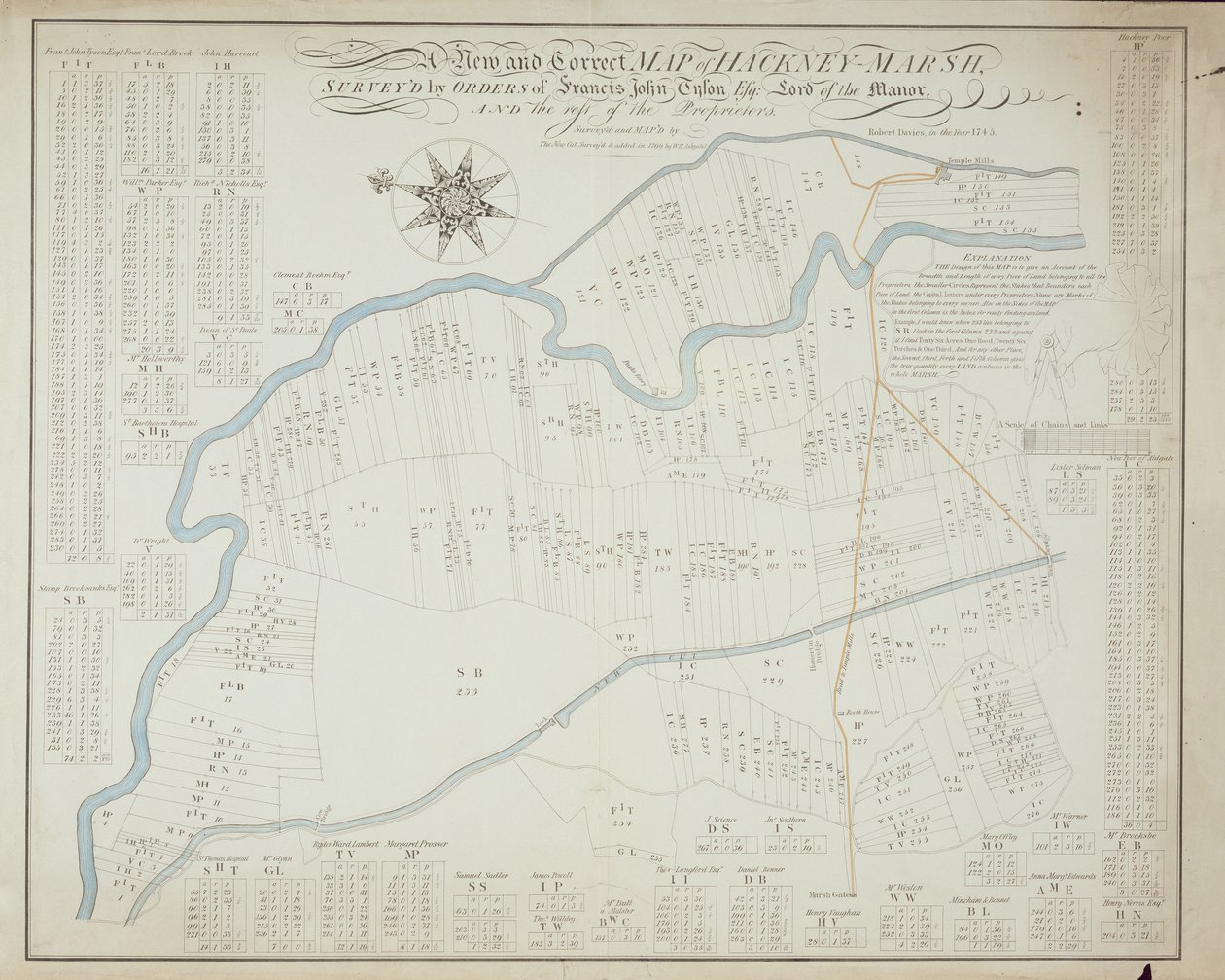
A New and Correct Map of Hackney Marsh, 1745 by Robert Davies

A New and Correct Map of Hackney Marsh, 1745

(A New and Correct Map of Hackney Marsh, 1745 )


Robert Davies

€ 110.52
Enthält 0% MwSt.
   Configure art print
1745  ·  lithograph  ·  Picture ID: 155389

Nonclassified artists  ·  Cartography

A New and Correct Map of Hackney Marsh, 1745 by Robert Davies. Available as an art print on canvas, photo paper, watercolor board, uncoated paper or Japanese paper.
north east london · plan · city · owners · proprietor · river · marshes · river lea · new cut · Lee navigation · Private Collection / Bridgeman Images
zu Favoriten hinzufügen   Add to favorites    Select wall color    View painting in a room AR/3D   View in 3D / AR
0 Reviews

Configure art print

Picture Frame

Medium & Stretcher

Glass & Passepartout

Miscellaneous & Extras

 Save / compare configuration
Preview Icon

Summary

Gemälde
Veredelung
Keilrahmen
Museumslizenz

€ 110.52
(inkl. 20% MwSt)
   Add to cart

Bildschärfe: PERFEKT

Should you desire adjustments to brightness and color, or a custom crop of the motif, we are happy to make these changes at no additional cost to you. Please do not hesitate to contact us.

Similar artworks selected for you

Map of Willesden, London (litho) A Topographical Sketch of New York A survey of the Kings lordship or manor of East Greenwich Map of Willesden, London Map of Yorktown, Virginia, October 1781 Draft for the Park Layout at the Future Royal Residence in Christiania A Collection of Surveys of Scottish Estates of the Earl of Selkirk: Culdooch Map of the Parish or Borough of Leeds Map of Hoogly River Plan of Faux Hall [now Vauxhall] manor, in Lambeth, co. Surrey Map of Leeds, surveyed by John Tuke Fireman A Plan of the Town of New Haven Battle of Camden, Augt. 16 Battle of Green Spring, Map of the Land on the Left Bank of the James River Opposite Jamestown in Virginia Where the Battle of July 6 Map of Lismore, Ireland Waller County, Texas Manhattan Island from the Battery to Above Turtle Bay Map for the Battle of Austerlitz, December 2nd, 1805 Section of the Northern Course of the Canal from the Tide in the Elk River at Frenchtown to the Forked [Oak] in Mr. Rudulph Vicinity of Harpers Ferry Map of Amsterdam and Surrounding Areas St. Helen Plan of the proposed navigable canal between river Kennet at Newbury in Berks and river Avon in Somerset: whereby a navigable communication will be opened between London and Bristol [also] Wilts & Berks & Somerset Coal Canals, surveyed by John Rennie Map of the mouth of the Chicago River, Illinois with the plan of the proposed piers for improving the harbour A Collection of Surveys of Scottish Estates of the Earl of Selkirk: Little Stockartown and Jurdiland The map is hand-drawn (ca 1780) and shows Telemark Map of Ivry and the surrounding area 1870 Copy of Map from 1599 of Haarlem Bleachfields Near Bloemendaal
Show more similar artworks

Other motives from the category Cartography

Partial Map of Middle East in the 1890s, from East Africa and the Red Sea with Prester John and the Legendary Kings of Africa, detail from a map of the Mediterranean Sea by Vesconte de Maggiolo, 1563 Map of the Passage of the Beresina, published by William Blackwood and Sons, Edinburgh and London, 1848 Map of the World, Based on Descriptions and Coordinates Given in Map of Laputa, Balnibari, Luggnagg, Glubbdubdrib and Japan, illustration from the first edition of Map of Cambridge, from A Map of Mile End and Stepney Green, London, 1746 Map of Ireland Map of Africa, Published in 1700, Paris Map of the City of New York [as far north as East 53rd Street], 1885 Map of the Southeastern Part of North America, 1721 Map of the West Indies, Florida and South America Ms. 988 Vol.3, fol.61 Map of America and Directions to China Map of New Spain, New Galicia and Guatemala, 1625
View More from "Cartography"

Excerpt from our top sellers

Thalia, the Muse of Comedy The Olive Trees Caresses, 1896 The Butterfly Hunter Roses Pink Peach Trees (Souvenir of Mauve) Trail in the Woods Rosa Damascena, from Les Roses, 1817-24 The Lady with an Ermine Under the Wave off Kanagawa Winter Landscape with Skaters and a Bird Trap Bauhaus Staircase The School of Athens Strolling along the Seashore, 1909 Cupid as Victor
Show More Artworks


What our customers think about us


Frequently Asked Questions about Meisterdrucke


Personalizing your art print at Meisterdrucke is a simple and intuitive process that allows you to design an artwork exactly to your specifications: Choose a frame, determine the image size, decide on a printing medium, and add suitable glazing or a stretcher frame. We also offer customization options such as mats, fillets, and spacers. Our customer service is available to help you design your perfect artwork.

At Meisterdrucke, you have the fascinating option to visualize the artwork you configured directly in your own space. For a tailored preview, simply upload a photo of your room and let the artwork appear on it. If you visit us via a mobile device, be it a phone or tablet, our augmented reality feature brings the image to life and seamlessly projects it into your space. An experience that uniquely combines art and technology.

Choosing the medium is often a matter of personal taste. To give you a clearer idea, we have provided some images for each medium. For a holistic experience, we also offer you a sample set of all paper variants so you can make a decision not just visually but also haptically. You can take advantage of the sample set free of charge – only the shipping costs will apply. You can order the sample set directly.

Do not worry. At Meisterdrucke, we do not proceed mechanically. We manually review each order. If there are any inconsistencies or peculiarities in the configuration, we will immediately contact you. Of course, our courteous and patient support is always at your side to assist you with the configuration. Together with you, we adjust your image by phone or email so that the final result exactly meets your expectations.


Do you have any questions?

Are you interested in an art print from our manufactory but still unsure? Do you need advice on choosing the medium or help with the order?

Our experts are happy to assist you.

+43 4257 29415
support@meisterdrucke.com
Mo-Do: 7:00 - 16:00 | Fr: 7:00 - 13:00

Do you have any questions?

Are you interested in an art print from our manufactory but still unsure? Do you need advice on choosing the medium or help with the order?

Our experts are happy to assist you.

+43 4257 29415
support@meisterdrucke.com
Mo-Do: 7:00 - 16:00 | Fr: 7:00 - 13:00


Meisterdrucke

   Kärntner Strasse 46
        9586 Finkenstein am Faaker See
        Austria
        +43 4257 29415
        support@meisterdrucke.com
Other languages

                   
Erfahrungen & Bewertungen zu Meisterdrucke
Partner Logos

Kaiser Franz Joseph

Meisterdrucke
Kärntner Strasse 46
9586 Finkenstein am Faaker See · Austria
+43 4257 29415 · office@meisterdrucke.com
Partner Logos


(c) 2025 meisterdrucke.us