The South Pole, (detail) from the

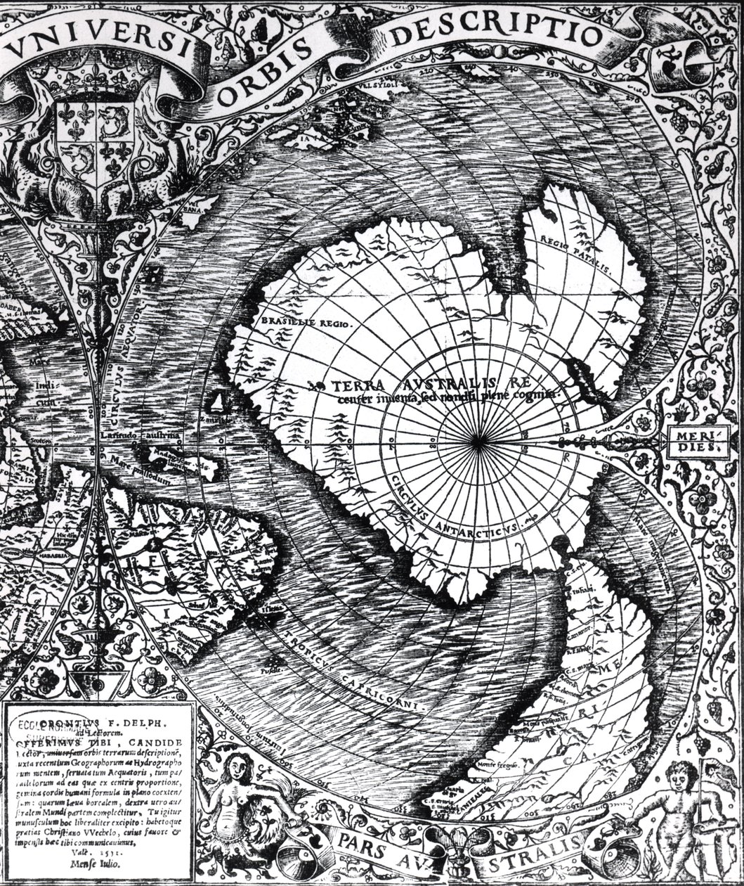
The South Pole, (detail) from the 'Mappamonde a Projection Cordiforme', 1531

(The South Pole, detail from the 'Mappamonde a Projection Cordiforme', 1531 )


Oronce Fine

€ 109.31
Enthält 0% MwSt.
   Configure art print
1531  ·  Gravur  ·  Picture ID: 189694

Nonclassified artists  ·  Cartography

The South Pole, (detail) from the 'Mappamonde a Projection Cordiforme', 1531 by Oronce Fine. Available as an art print on canvas, photo paper, watercolor board, uncoated paper or Japanese paper.
le pole sud · southern · terra australlis · antarctic · world map · Private Collection / Bridgeman Images
AR/3D   View in 3D / AR zu Favoriten hinzufügen   Add to favorites    Select wall color    View painting in a room
0 Reviews

Configure art print

Picture Frame

Medium & Stretcher

Glass & Passepartout

Miscellaneous & Extras

 Save / compare configuration
Preview Icon

Summary

Gemälde
Veredelung
Keilrahmen
Museumslizenz

€ 109.31
(inkl. 20% MwSt)
   Add to cart

Bildschärfe: PERFEKT

Should you desire adjustments to brightness and color, or a custom crop of the motif, we are happy to make these changes at no additional cost to you. Please do not hesitate to contact us.

Similar artworks selected for you

Ptolemy of Alexandria Part of Captain J Smith Map of the North Pole and Northern Areas (1628) The North Polar Regions Iceland, circa 1539 (detail) Map of the Mercator Projection A Map of the Americas Plan of the Bay and Harbour of Rio de Janeiro on the Coast of Brazil Map of the Lands Around the Arctic Circle with the Three Voyages of the Dutch, 1598 A Map of the North Pole Septentrionalium terrarum descriptio, map of the Arctic, 1595 World Map; Vera Totius Expeditionis Nauticae, charting the circumnavigation of the globe by Sir Francis Drake and Thomas Cavendish c.1595 Map of the Countries Around the Arctic Circle with the Three Voyages of the Dutch in 1598 Maps of Holy Island and Farne Island, Northumberland Robert Falcon Scott Map of North and South America Showing the Connection of the Two Continents by an Isthmus. Published in Map of Europe, Africa, and the Americas Map of the voyage of the The Cottoniana or Anglo-Saxon Map MS Tib. BV Bristol Channel World Map, Mundu [sic] Spericum... Cognosces Diligentia Joani Mathei Contareni, by Contarini, Giovanni and Francesco Rosselli Map of the New England coastline in 1614, engraved by Simon de Passe Map Showing Drake Southern Celestial Images Map including Massachusetts Bay Constellations of the Southern Hemisphere, from the This is Probably the Earliest Perspective Representation of the Earth as a Globe Part of Captain John Smith New and Accurate Map of the Lands and Kingdoms of California, New Spain, Mexico, and Peru
Show more similar artworks

Other motives from the category Cartography

A new map of the United States with the additional territories on an improved plan A Map of Mile End and Stepney Green, London, 1746 Map of Greece, Hungary and Their Surrounding Countries Map of the Strait of Malacca Map of Armenia Map of Spain and Portugal Map of the world, based on descriptions and co-ordinates given in Map of India, Showing the Railways Finished, in Progress and Intended, the Cotton and Coal Districts Map of China showing the Position of the Provinces and Towns under Insurrection Map of Turkey, Middle East Horn of Africa and Persian Gulf in the 1890s, from A Map of Bloomsbury and Holborn, London Map of Rovigo, from Map of the Southern Hemisphere, from Partial Map of the Middle East Showing the Red Sea, Persian Gulf and Horn of Africa in the 1890s, from Map of Laputa, Balnibari, Luggnagg, Glubbdubdrib and Japan, illustration from the first edition of
View More from "Cartography"

Excerpt from our top sellers

The Scream Girl with a Pearl Earring The Waterlily Pond with the Japanese Bridge Noon The School of Athens, from the Stanza della Segnatura The Wild Rabbit Poster, 1899 Geranium, Mexico City Oriental Nude Mars and Venus, Allegory of Peace Roses Uttewalder Grund A Storm in the Rocky Mountains, Mt. Rosalie Four Foxes Pillars of Creation (NIRCam and MIRI Composite) Horse Study
Show More Artworks


What our customers think about us


Frequently Asked Questions about Meisterdrucke


Personalizing your art print at Meisterdrucke is a simple and intuitive process that allows you to design an artwork exactly to your specifications: Choose a frame, determine the image size, decide on a printing medium, and add suitable glazing or a stretcher frame. We also offer customization options such as mats, fillets, and spacers. Our customer service is available to help you design your perfect artwork.

At Meisterdrucke, you have the fascinating option to visualize the artwork you configured directly in your own space. For a tailored preview, simply upload a photo of your room and let the artwork appear on it. If you visit us via a mobile device, be it a phone or tablet, our augmented reality feature brings the image to life and seamlessly projects it into your space. An experience that uniquely combines art and technology.

Choosing the medium is often a matter of personal taste. To give you a clearer idea, we have provided some images for each medium. For a holistic experience, we also offer you a sample set of all paper variants so you can make a decision not just visually but also haptically. You can take advantage of the sample set free of charge – only the shipping costs will apply. You can order the sample set directly.

Do not worry. At Meisterdrucke, we do not proceed mechanically. We manually review each order. If there are any inconsistencies or peculiarities in the configuration, we will immediately contact you. Of course, our courteous and patient support is always at your side to assist you with the configuration. Together with you, we adjust your image by phone or email so that the final result exactly meets your expectations.


Do you have any questions?

Are you interested in an art print from our manufactory but still unsure? Do you need advice on choosing the medium or help with the order?

Our experts are happy to assist you.

+43 4257 29415
support@meisterdrucke.com
Mo-Do: 7:00 - 16:00 | Fr: 7:00 - 13:00

Do you have any questions?

Are you interested in an art print from our manufactory but still unsure? Do you need advice on choosing the medium or help with the order?

Our experts are happy to assist you.

+43 4257 29415
support@meisterdrucke.com
Mo-Do: 7:00 - 16:00 | Fr: 7:00 - 13:00


Meisterdrucke

   Kärntner Strasse 46
        9586 Finkenstein am Faaker See
        Austria
        +43 4257 29415
        support@meisterdrucke.com
Other languages

                   
Erfahrungen & Bewertungen zu Meisterdrucke
Post.at DHL Express Quehenberger Cargoboard
Kaiser Franz Joseph

Meisterdrucke
Kärntner Strasse 46
9586 Finkenstein am Faaker See · Austria
+43 4257 29415 · office@meisterdrucke.com
Post.at DHL Express Quehenberger Cargoboard


Meisterdrucke 2705 Bewertungen auf ProvenExpert.com

(c) 2025 meisterdrucke.us