support@meisterdrucke.com  ·  0043 4257 29415

Deutsch English Italiano Español Français Nederlands Português Svenska Polski Dansk
Search by artist, work title or style – e.g. Monet, Starry Night, Impressionism, Hokusai wave, nude. Describe the scene – e.g. green meadow, abstract with lots of red, dark oil painting, standing nude next to a tree.

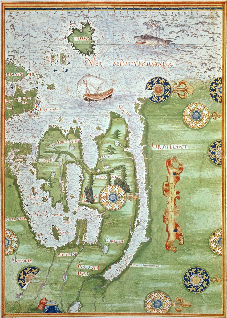
Fol. 10v Map of Scandinavia and Northern Russia, from 'Cosmographie Universelle', 1555 by Guillaume Le Testu

Fol. 10v Map of Scandinavia and Northern Russia, from 'Cosmographie Universelle', 1555

(Fol.10v Map of Scandinavia and Northern Russia, from 'Cosmographie Universelle', 1555 )


Guillaume Le Testu

€ 130.83
Tax-free
   Configure art print
1555  ·  Watercolor on paper  ·  Image ID: 113304

Nonclassified artists  ·  Cartography

Fol. 10v Map of Scandinavia and Northern Russia, from 'Cosmographie Universelle', 1555 by Guillaume Le Testu. Available as an art print on canvas, photo paper, watercolor board, natural paper, or Japanese paper.
scandinavia · northern russia · north · finland · norway · greenland · scandinavian · ocean · Renaissance · Min. Defense - Service Historique de l'Armee de Terre,France / Bridgeman Images
AR/3D   View in 3D / AR zu Favoriten hinzufügen   Add to favorites    Change wall color    View picture in a room
0 Reviews

Configure art print

Picture Frame

Medium & Stretcher

Glass & Passepartout

Miscellaneous & Extras

 Save / compare configuration
Preview Icon

Summary

Gemälde
Veredelung
Keilrahmen
Museumslizenz

€ 130.83
(inkl. 20% MwSt)
   Add to cart

Bildschärfe: PERFEKT

If you'd like us to adjust the brightness, colors, or crop the image, we're happy to do this for you at no extra cost. Just get in touch!

Similar artworks selected for you

Fol. 31v Map of Australia and Magellan Island from “Cosmographie Universelle”, 1555 Fol. 30v Map of the Sea of Maluku, from the The New Islands, Behind Spain Towards the Orient by the Land of India Fol. 40v, Map of the Magellan Straits, from Fol. 47v Map of Peru, from Fol. 41v, Map of Australia, from Fol. 34v, Map of Australia, from The Spice Trade in the Moloccas, from Fol. 39v Map of the Magellan Straits, from “Cosmographie Universelle”, 1555 Northern Europe, from Atlas of the World in thirty-three Maps Map of Netherlands, from Theatrum Orbis Terrarum by Abraham Ortelius A Chart of Khios and Adjacent Mainland, c.1420 Map of Smerwick, Ireland, Showing the English Earthwork with Two Guns for Attacking the Spanish Fort and English Soldiers Marching Out of Castell More Dutch Trade Map of the Baltic Sea Map of the China Sea, from a facsimile of the Miller Atlas by Pedro and Jorge Reinel, and Lopo Homem, made in 1519 Oversize Atlas Titled Fol. 44v Map of Brazil, from Map of Europe, from a facsimile of the ‘Miller Atlas’ by Pedro and Jorge Reinel, and Lopo Homem, made in 1519 Northern Europe: Iceland, from Atlas of the World in thirty-three Maps Eastern Europe and Central Asia, from Atlas of the World in Thirty-Three Maps The famous West Indian voyage made by the English Fleet of 23 ships and barks wherein were gotten the towns of St. Iago, Sto Domingo, Cartagena and St. Augustines Map of Asia, including Armenia, Iran and Afghanistan, with wind rose, details of ports, coasts and sea routes, in the Atlas of Joan Martines Map of Cartagena Portland Bill to Portsmouth: The Pursuit of the Spanish Armada by the English Fleet View of the Archipelago of Borneo (detail) 1592 Map of Africa Map, illustration from the Illustration from the F.52v Map of Florida and the Antilles, from
Show more similar artworks

Similar artworks selected for you

Fol. 31v Map of Australia and Magellan Island from “Cosmographie Universelle”, 1555 Fol. 30v Map of the Sea of Maluku, from the The New Islands, Behind Spain Towards the Orient by the Land of India Fol. 40v, Map of the Magellan Straits, from Fol. 47v Map of Peru, from Fol. 41v, Map of Australia, from Fol. 34v, Map of Australia, from The Spice Trade in the Moloccas, from Fol. 39v Map of the Magellan Straits, from “Cosmographie Universelle”, 1555 Northern Europe, from Atlas of the World in thirty-three Maps Map of Netherlands, from Theatrum Orbis Terrarum by Abraham Ortelius A Chart of Khios and Adjacent Mainland, c.1420 Map of Smerwick, Ireland, Showing the English Earthwork with Two Guns for Attacking the Spanish Fort and English Soldiers Marching Out of Castell More Dutch Trade Map of the Baltic Sea Map of the China Sea, from a facsimile of the Miller Atlas by Pedro and Jorge Reinel, and Lopo Homem, made in 1519 Oversize Atlas Titled Fol. 44v Map of Brazil, from Map of Europe, from a facsimile of the ‘Miller Atlas’ by Pedro and Jorge Reinel, and Lopo Homem, made in 1519 Northern Europe: Iceland, from Atlas of the World in thirty-three Maps Eastern Europe and Central Asia, from Atlas of the World in Thirty-Three Maps The famous West Indian voyage made by the English Fleet of 23 ships and barks wherein were gotten the towns of St. Iago, Sto Domingo, Cartagena and St. Augustines Map of Asia, including Armenia, Iran and Afghanistan, with wind rose, details of ports, coasts and sea routes, in the Atlas of Joan Martines Map of Cartagena Portland Bill to Portsmouth: The Pursuit of the Spanish Armada by the English Fleet View of the Archipelago of Borneo (detail) 1592 Map of Africa Map, illustration from the Illustration from the F.52v Map of Florida and the Antilles, from
Show more similar artworks

More art prints by Guillaume Le Testu

F.52v Map of Florida and the Antilles, from Fol. 57v Map of Canada and Florida, from Fol. 30v Map of the Sea of Maluku, from the Fol. 9v, Map of Western Europe, from Fol. 31v Map of Australia and Magellan Island from “Cosmographie Universelle”, 1555 Fol. 34v, Map of Australia, from Fol. 7v: Map of the North Pole, from Fol.56v Map of Florida, Canada and Labrador, from Fol. 54v Map of Florida, from “Cosmographie Universelle”, 1555 Fol. 41v, Map of Australia, from Fol. 39v Map of the Magellan Straits, from “Cosmographie Universelle”, 1555 Fol. 40v, Map of the Magellan Straits, from Fol. 47v Map of Peru, from Fol. 44v Map of Brazil, from Fol. 10v Map of Scandinavia and Northern Russia, from
Show more works by Guillaume Le Testu

More art prints by Guillaume Le Testu

F.52v Map of Florida and the Antilles, from Fol. 57v Map of Canada and Florida, from Fol. 30v Map of the Sea of Maluku, from the Fol. 9v, Map of Western Europe, from Fol. 31v Map of Australia and Magellan Island from “Cosmographie Universelle”, 1555 Fol. 34v, Map of Australia, from Fol. 7v: Map of the North Pole, from Fol.56v Map of Florida, Canada and Labrador, from Fol. 54v Map of Florida, from “Cosmographie Universelle”, 1555 Fol. 41v, Map of Australia, from Fol. 39v Map of the Magellan Straits, from “Cosmographie Universelle”, 1555 Fol. 40v, Map of the Magellan Straits, from Fol. 47v Map of Peru, from Fol. 44v Map of Brazil, from Fol. 10v Map of Scandinavia and Northern Russia, from
Show more works by Guillaume Le Testu

More motifs from the category Cartography

Map of Galicia with the route of the French army and a log, from the campaign in January, 1809 Map of Milan, from Civitates Orbis Terrarum by Georg Braun (1541-1622) and Frans Hogenburg (1535-90), c. 1572 Map of the United States, 1816 Map of Venice, first half of 17th century (panel) (detail of 64062) Map of the Western Part of the Roman Empire, 1763 A Map of St Paul A Map of the Royal Palace and Gardens of Kensington, London, 1736 Map of the Battle of Talavera, published by William Blackwood and Sons, Edinburgh and London, 1848 (hand-coloured engraving) Plan and map of the town and citadel of Mont-Louis, 1776 The First Western Atlas Map of China, from the Ortelius Theatrum Atlas, 1584 Loggan Map of Linz, from ’Civitates Orbis Terrarum’ by Georg Braun (1541-1622) and Frans Hogenberg (1535-90), 1594 Map of Granada, from Civitates Orbis Terrarum by Georg Braun (1541-1622) and Frans Hogenberg (1535-90), 1563 Insurance Map of the City of Philadelphia; volume 2, plate 15, 1887 Map No. 5 Showing the route of the Armada fleet, engraved by Augustine Ryther, 1588
View More from "Cartography"

More motifs from the category Cartography

Map of Galicia with the route of the French army and a log, from the campaign in January, 1809 Map of Milan, from Civitates Orbis Terrarum by Georg Braun (1541-1622) and Frans Hogenburg (1535-90), c. 1572 Map of the United States, 1816 Map of Venice, first half of 17th century (panel) (detail of 64062) Map of the Western Part of the Roman Empire, 1763 A Map of St Paul A Map of the Royal Palace and Gardens of Kensington, London, 1736 Map of the Battle of Talavera, published by William Blackwood and Sons, Edinburgh and London, 1848 (hand-coloured engraving) Plan and map of the town and citadel of Mont-Louis, 1776 The First Western Atlas Map of China, from the Ortelius Theatrum Atlas, 1584 Loggan Map of Linz, from ’Civitates Orbis Terrarum’ by Georg Braun (1541-1622) and Frans Hogenberg (1535-90), 1594 Map of Granada, from Civitates Orbis Terrarum by Georg Braun (1541-1622) and Frans Hogenberg (1535-90), 1563 Insurance Map of the City of Philadelphia; volume 2, plate 15, 1887 Map No. 5 Showing the route of the Armada fleet, engraved by Augustine Ryther, 1588
View More from "Cartography"

A selection of our top sellers

The Grammont Bridge in Monet The Course of Empire: The Arcadian or Pastoral State The Kiss, 1895 The Harvesters Olive Trees in the Moreno Garden, 1884 Let the Little Children Come to Me Reflection in the Surface of the Water, Misaka, Kai Province from the series Thirty-Six Views of Mt Fuji, 1830-1833 Continuous Line The Tortoise Trainer The Dreamer The Red Tree Portrait of a young woman, drawing Poppy field The Butterfly Hunter
Show more artworks

A selection of our top sellers

The Grammont Bridge in Monet The Course of Empire: The Arcadian or Pastoral State The Kiss, 1895 The Harvesters Olive Trees in the Moreno Garden, 1884 Let the Little Children Come to Me Reflection in the Surface of the Water, Misaka, Kai Province from the series Thirty-Six Views of Mt Fuji, 1830-1833 Continuous Line The Tortoise Trainer The Dreamer The Red Tree Portrait of a young woman, drawing Poppy field The Butterfly Hunter
Show more artworks


What our customers think about us


Frequently Asked Questions about Meisterdrucke


Personalizing your art print at Meisterdrucke is simple and intuitive: Choose a frame, set the image size, pick a printing medium, and add suitable glazing or a stretcher frame. We also offer additional customization options like mats, fillets, and spacers. If you have any questions, our customer service team is ready to help you create your perfect artwork.

At Meisterdrucke, you can visualize your configured artwork directly in your own room. Simply upload a photo of your space and see how the artwork looks in it. If you're visiting us on a mobile device — phone or tablet — our augmented reality feature brings the picture to life and projects it right into your room. A unique experience that combines art and technology.

Choosing the right medium is often a matter of personal taste. To give you a better idea, we've provided some images for each medium. We also offer a sample set of all paper variants, so you can decide not just visually but by touch as well. You can order the sample set free of charge — only shipping costs apply.

Don't worry! At Meisterdrucke, we don't just process orders mechanically. Every order is manually reviewed by our team. If we spot any inconsistencies or issues with your configuration, we'll get in touch with you right away. And of course, our friendly and patient support team is always here to help you with your configuration. We'll work with you by phone or email to adjust your image so the final result is exactly what you had in mind.


Still have questions?

Are you interested in an art print from our manufactory but still unsure? Do you need advice on choosing the medium or help with the order?

Our experts are happy to assist you.

+43 4257 29415
support@meisterdrucke.com
Mo-Do: 7:00 - 16:00 | Fr: 7:00 - 13:00

Still have questions?

Are you interested in an art print from our manufactory but still unsure? Do you need advice on choosing the medium or help with the order?

Our experts are happy to assist you.

+43 4257 29415
support@meisterdrucke.com
Mo-Do: 7:00 - 16:00 | Fr: 7:00 - 13:00


Meisterdrucke

   Kärntner Strasse 46
        9586 Finkenstein am Faaker See
        Austria
        +43 4257 29415
        support@meisterdrucke.com
Other languages

                   
Erfahrungen & Bewertungen zu Meisterdrucke
Post.at DHL Express Quehenberger Cargoboard
Kaiser Franz Joseph

Meisterdrucke
Kärntner Strasse 46
9586 Finkenstein am Faaker See · Austria
+43 4257 29415 · support@meisterdrucke.com
Post.at DHL Express Quehenberger Cargoboard


(c) 2026 meisterdrucke.us