support@meisterdrucke.com  ·  0043 4257 29415

Deutsch English Italiano Español Français Nederlands Português Svenska Polski Dansk
Search by artist, work title or style – e.g. Monet, Starry Night, Impressionism, Hokusai wave, nude. Describe the scene – e.g. green meadow, abstract with lots of red, dark oil painting, standing nude next to a tree.

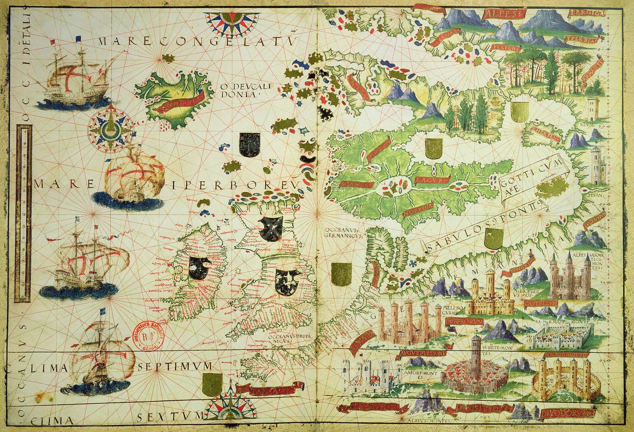
Map of Europe, from a facsimile of the ‘Miller Atlas’ by Pedro and Jorge Reinel, and Lopo Homem, made in 1519 by Unbekannt Unbekannt

Map of Europe, from a facsimile of the ‘Miller Atlas’ by Pedro and Jorge Reinel, and Lopo Homem, made in 1519

(Map of Europe, from a facsimile of the 'Miller Atlas' by Pedro and Jorge Reinel, and Lopo Homem, made in 1519)


Unbekannt Unbekannt

€ 134.56
Tax-free
   Configure art print
16th century  ·  Image ID: 72117

Nonclassified artists  ·  Cartography

Map of Europe, from a facsimile of the ‘Miller Atlas’ by Pedro and Jorge Reinel, and Lopo Homem, made in 1519 by Unbekannt Unbekannt. Available as an art print on canvas, photo paper, watercolor board, natural paper, or Japanese paper.
cartography · britain · england · ireland · germany · scandinavia · castle · castles · atlantic · Bibliotheque Nationale, Paris, France / Bridgeman Images
AR/3D   View in 3D / AR zu Favoriten hinzufügen   Add to favorites    Change wall color    View picture in a room

Note: Only reviews with comments are displayed. Reviews can be submitted directly after purchase in your customer account.

Configure art print

Picture Frame

Medium & Stretcher

Glass & Passepartout

Miscellaneous & Extras

 Save / compare configuration
Preview Icon

Summary

Gemälde
Veredelung
Keilrahmen
Museumslizenz

€ 134.56
(inkl. 20% MwSt)
   Add to cart

Bildschärfe: PERFEKT

If you'd like us to adjust the brightness, colors, or crop the image, we're happy to do this for you at no extra cost. Just get in touch!

Similar artworks selected for you

Chart of Arabia and the Eastern Mediterranean, Part of a Portolan Atlas, c.1650 Map of the China Sea, from a facsimile of the Miller Atlas by Pedro and Jorge Reinel, and Lopo Homem, made in 1519 A map of Africa, south of the equator, with part of the Indian Ocean, from “An atlas of 17 sea charts by Joan Martines” Miller Atlas, c1519 Map, illustration from the Illustration from the The Indes Portuguese nautical atlas. Page of the Atlas Miller manuscript made in 1519 by Pierre and Georges Reinel, Lopo Homem (cartographers) and Antoine de Hollande (miniaturist) Fol. 5v Map of Great Britain, Europe and North West Africa, from Portugaliae Monumenta Cartographica, an account of the discoveries of Fernão Gomes from 1470-75, 1563 Portolan chart of the Atlantic Ocean, Mediterranean and Black Sea, c.1535 Chart of the Western Mediterranean Showing the North African and Spanish Coasts Chart of the Atlantic Ocean, Mediterranean and Black Sea, c.1535 This Type of Early Vellum Sea Chart Originated in the Mediterranean in the 13th Century Chart of the Eastern Mediterranean, c.1600 Provence and Italy, from a nautical atlas, 1520 (detail from 330915) The Eastern Mediterranean, from a nautical atlas, 1520 Arabia and India, from the Add. 31318 B Map of Europe, Asia Minor, and Africa, as far south as Cape Rosso, vellum Chart of the Western Mediterranean, c.1600 Ms. Ital. 550.0.3.15, fol. 4v-5r. Map of the Eastern Mediterranean Coast and Islands, from the „Carte Geografiche“ Hydrographic map of Brazil Chart of the north-east Atlantic, from Ireland to Cape Verde, c.1600 Fol. 47v Map of Peru, from Mediterranean Mainland Southeast Asia, detail from a world atlas Greek Archipelago, c.1620 Fol. 16 Map of Persia, Arabia and India, from an atlas, 1571 A Mediterranean Chart Showing the North East Atlantic Portolan Chart, by Jaume Olives The Atlantic coasts of Europe and the Western Mediterranean, from a nautical atlas
Show more similar artworks

Similar artworks selected for you

Chart of Arabia and the Eastern Mediterranean, Part of a Portolan Atlas, c.1650 Map of the China Sea, from a facsimile of the Miller Atlas by Pedro and Jorge Reinel, and Lopo Homem, made in 1519 A map of Africa, south of the equator, with part of the Indian Ocean, from “An atlas of 17 sea charts by Joan Martines” Miller Atlas, c1519 Map, illustration from the Illustration from the The Indes Portuguese nautical atlas. Page of the Atlas Miller manuscript made in 1519 by Pierre and Georges Reinel, Lopo Homem (cartographers) and Antoine de Hollande (miniaturist) Fol. 5v Map of Great Britain, Europe and North West Africa, from Portugaliae Monumenta Cartographica, an account of the discoveries of Fernão Gomes from 1470-75, 1563 Portolan chart of the Atlantic Ocean, Mediterranean and Black Sea, c.1535 Chart of the Western Mediterranean Showing the North African and Spanish Coasts Chart of the Atlantic Ocean, Mediterranean and Black Sea, c.1535 This Type of Early Vellum Sea Chart Originated in the Mediterranean in the 13th Century Chart of the Eastern Mediterranean, c.1600 Provence and Italy, from a nautical atlas, 1520 (detail from 330915) The Eastern Mediterranean, from a nautical atlas, 1520 Arabia and India, from the Add. 31318 B Map of Europe, Asia Minor, and Africa, as far south as Cape Rosso, vellum Chart of the Western Mediterranean, c.1600 Ms. Ital. 550.0.3.15, fol. 4v-5r. Map of the Eastern Mediterranean Coast and Islands, from the „Carte Geografiche“ Hydrographic map of Brazil Chart of the north-east Atlantic, from Ireland to Cape Verde, c.1600 Fol. 47v Map of Peru, from Mediterranean Mainland Southeast Asia, detail from a world atlas Greek Archipelago, c.1620 Fol. 16 Map of Persia, Arabia and India, from an atlas, 1571 A Mediterranean Chart Showing the North East Atlantic Portolan Chart, by Jaume Olives The Atlantic coasts of Europe and the Western Mediterranean, from a nautical atlas
Show more similar artworks

More art prints by Unbekannt Unbekannt

Lascaux Cave Painting, Bordeaux, France Wall painting of a bird in a garden, Pompeii, 1st century AD Garden Paintings from the so-called Villa of Livia, Primaporta, Rome, c. 20 BC Photographic reproduction of the Great Isaiah Scroll, the best preserved of the biblical scrolls found at Qumran. It contains the entire Book of Isaiah in Hebrew, apart from some small damaged parts. This manuscript was probably written by a scribe of the Faust and Mephisto Playing Chess Night Parade of a Hundred Demons Archer, cave painting, Tassili n Oscar Wilde and Lord Alfred Douglas, 1894 Death comes for the Unbelieving Woman, from “Der Todten Tanz”, published Basel, 1843 Bison Painting in the Altamira Caves, Upper Paleolithic Museum, Santander, Cantabria, Spain Early light bulbs: left: first commercial light bulb, right: electric filament lamp made by Thomas Alva Edison Examples of Ionic and Corinthian orders in Greek architecture, from The National Encyclopaedia, published c.1890 Sidewall (5492476) Guhyasamaja, Akshobhyavajra The Unicorn in Captivity
Show more works by Unbekannt Unbekannt

More art prints by Unbekannt Unbekannt

Lascaux Cave Painting, Bordeaux, France Wall painting of a bird in a garden, Pompeii, 1st century AD Garden Paintings from the so-called Villa of Livia, Primaporta, Rome, c. 20 BC Photographic reproduction of the Great Isaiah Scroll, the best preserved of the biblical scrolls found at Qumran. It contains the entire Book of Isaiah in Hebrew, apart from some small damaged parts. This manuscript was probably written by a scribe of the Faust and Mephisto Playing Chess Night Parade of a Hundred Demons Archer, cave painting, Tassili n Oscar Wilde and Lord Alfred Douglas, 1894 Death comes for the Unbelieving Woman, from “Der Todten Tanz”, published Basel, 1843 Bison Painting in the Altamira Caves, Upper Paleolithic Museum, Santander, Cantabria, Spain Early light bulbs: left: first commercial light bulb, right: electric filament lamp made by Thomas Alva Edison Examples of Ionic and Corinthian orders in Greek architecture, from The National Encyclopaedia, published c.1890 Sidewall (5492476) Guhyasamaja, Akshobhyavajra The Unicorn in Captivity
Show more works by Unbekannt Unbekannt

More motifs from the category Cartography

Map of Palestine, Palestina Antiqua, from Samuel Butler Map of Asia, from the A Map of Limehouse and Rotherhithe, London, 1746 Map of the Siege of San Sebastián, published by William Blackwood and Sons, Edinburgh and London, 1848 Map of Catania, from "Civitates Orbis Terrarum" by Georg Braun (1541-1622) and Frans Hogenberg (1535-90), c. 1572 A Map of the Island of Juan Fernandez, printed in ’Providence Displayed: or The Remarkable Adventures of Alexander Selkirk of Largo, Scotland’ by Isaac James, published 1800 Map of the Moluccan Islands, engraved by Jodocus Hondius, 1630 Map of Rome, 1579 Map of Africa, published in 1700, Paris Map of England and Wales, 1644 A New Map of the County of Buckinghamshire Map of North and South America, from the Detail of Italy from the Peutinger map copy Map of Jerusalem, 1661 Map of the Battle of Friedland, published by William Blackwood and Sons, Edinburgh and London, 1848
View More from "Cartography"

More motifs from the category Cartography

Map of Palestine, Palestina Antiqua, from Samuel Butler Map of Asia, from the A Map of Limehouse and Rotherhithe, London, 1746 Map of the Siege of San Sebastián, published by William Blackwood and Sons, Edinburgh and London, 1848 Map of Catania, from "Civitates Orbis Terrarum" by Georg Braun (1541-1622) and Frans Hogenberg (1535-90), c. 1572 A Map of the Island of Juan Fernandez, printed in ’Providence Displayed: or The Remarkable Adventures of Alexander Selkirk of Largo, Scotland’ by Isaac James, published 1800 Map of the Moluccan Islands, engraved by Jodocus Hondius, 1630 Map of Rome, 1579 Map of Africa, published in 1700, Paris Map of England and Wales, 1644 A New Map of the County of Buckinghamshire Map of North and South America, from the Detail of Italy from the Peutinger map copy Map of Jerusalem, 1661 Map of the Battle of Friedland, published by William Blackwood and Sons, Edinburgh and London, 1848
View More from "Cartography"

A selection of our top sellers

The Night Watch The Butterfly Hunter The Buddha The Geographer Joan of Arc, 1865 Benedictine Monk with Wine at Morning Drinks The Almond Tree in Blossom, 1947 The Jumantsubo Plain in Susaki near Fukagawa, 1857 Tahiti: Tahitian Landscape, Paul Gauguin (1893) A guardian angel protects two children crossing a river on an old wooden bridge, early 20th century The Sun Fast Sinks in the West White-Bear-King-Valemon, 1912 Ball at the Moulin de la Galette Mori (Forest) The Harbour at Sunset, Opus 236 (Saint-Tropez), 1892
Show more artworks

A selection of our top sellers

The Night Watch The Butterfly Hunter The Buddha The Geographer Joan of Arc, 1865 Benedictine Monk with Wine at Morning Drinks The Almond Tree in Blossom, 1947 The Jumantsubo Plain in Susaki near Fukagawa, 1857 Tahiti: Tahitian Landscape, Paul Gauguin (1893) A guardian angel protects two children crossing a river on an old wooden bridge, early 20th century The Sun Fast Sinks in the West White-Bear-King-Valemon, 1912 Ball at the Moulin de la Galette Mori (Forest) The Harbour at Sunset, Opus 236 (Saint-Tropez), 1892
Show more artworks


What our customers think about us


Frequently Asked Questions about Meisterdrucke


Personalizing your art print at Meisterdrucke is simple and intuitive: Choose a frame, set the image size, pick a printing medium, and add suitable glazing or a stretcher frame. We also offer additional customization options like mats, fillets, and spacers. If you have any questions, our customer service team is ready to help you create your perfect artwork.

At Meisterdrucke, you can visualize your configured artwork directly in your own room. Simply upload a photo of your space and see how the artwork looks in it. If you're visiting us on a mobile device — phone or tablet — our augmented reality feature brings the picture to life and projects it right into your room. A unique experience that combines art and technology.

Choosing the right medium is often a matter of personal taste. To give you a better idea, we've provided some images for each medium. We also offer a sample set of all paper variants, so you can decide not just visually but by touch as well. You can order the sample set free of charge — only shipping costs apply.

Don't worry! At Meisterdrucke, we don't just process orders mechanically. Every order is manually reviewed by our team. If we spot any inconsistencies or issues with your configuration, we'll get in touch with you right away. And of course, our friendly and patient support team is always here to help you with your configuration. We'll work with you by phone or email to adjust your image so the final result is exactly what you had in mind.


Still have questions?

Are you interested in an art print from our manufactory but still unsure? Do you need advice on choosing the medium or help with the order?

Our experts are happy to assist you.

+43 4257 29415
support@meisterdrucke.com
Mo-Do: 7:00 - 16:00 | Fr: 7:00 - 13:00

Still have questions?

Are you interested in an art print from our manufactory but still unsure? Do you need advice on choosing the medium or help with the order?

Our experts are happy to assist you.

+43 4257 29415
support@meisterdrucke.com
Mo-Do: 7:00 - 16:00 | Fr: 7:00 - 13:00


Meisterdrucke

   Kärntner Strasse 46
        9586 Finkenstein am Faaker See
        Austria
        +43 4257 29415
        support@meisterdrucke.com
Other languages

                   
Erfahrungen & Bewertungen zu Meisterdrucke
Post.at DHL Express Quehenberger Cargoboard
Kaiser Franz Joseph

Meisterdrucke
Kärntner Strasse 46
9586 Finkenstein am Faaker See · Austria
+43 4257 29415 · support@meisterdrucke.com
Post.at DHL Express Quehenberger Cargoboard


(c) 2026 meisterdrucke.us