support@meisterdrucke.com  ·  0043 4257 29415

Deutsch English Italiano Español Français Nederlands Português Svenska Polski Dansk
Search by artist, work title or style – e.g. Monet, Starry Night, Impressionism, Hokusai wave, nude. Describe the scene – e.g. green meadow, abstract with lots of red, dark oil painting, standing nude next to a tree.

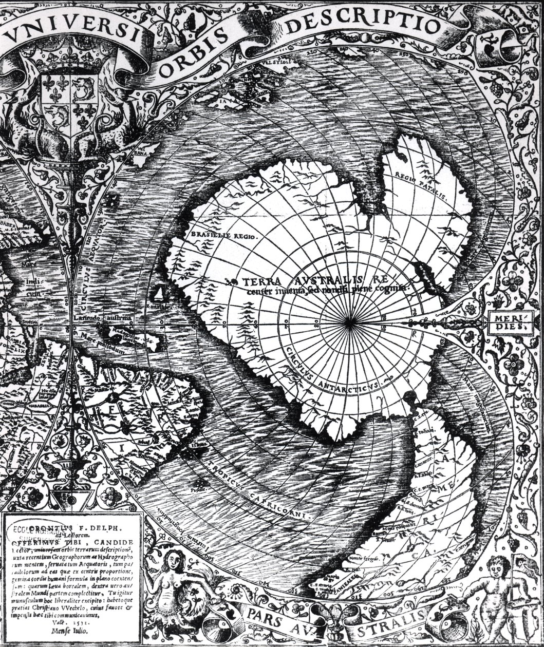
The South Pole, detail from the ’Mappamonde à Projection Cordiforme’, 1531 by Oronce Fine

The South Pole, detail from the ’Mappamonde à Projection Cordiforme’, 1531

(The South Pole, detail from the 'Mappamonde a Projection Cordiforme', 1531 )


Oronce Fine

€ 117.79
Tax-free
   Configure art print
1531  ·  engraving  ·  Image ID: 189694

Nonclassified artists  ·  Cartography

The South Pole, detail from the ’Mappamonde à Projection Cordiforme’, 1531 by Oronce Fine. Available as an art print on canvas, photo paper, watercolor board, natural paper, or Japanese paper.
le pole sud · southern · terra australlis · antarctic · world map · Private Collection / Bridgeman Images
AR/3D   View in 3D / AR zu Favoriten hinzufügen   Add to favorites    Change wall color    View picture in a room
0 Reviews

Configure art print

Picture Frame

Medium & Stretcher

Glass & Passepartout

Miscellaneous & Extras

 Save / compare configuration
Preview Icon

Summary

Gemälde
Veredelung
Keilrahmen
Museumslizenz

€ 117.79
(inkl. 20% MwSt)
   Add to cart

Bildschärfe: PERFEKT

If you'd like us to adjust the brightness, colors, or crop the image, we're happy to do this for you at no extra cost. Just get in touch!

Similar artworks selected for you

Ptolemy of Alexandria New and Complete Description of the Whole World Part of Captain J Smith Map of the North Pole and Northern Areas (1628) The North Polar Regions Iceland, circa 1539 (detail) A map of the Americas, 1590-1601 Plan of the Bay and Harbour of Rio de Janeiro on the Coast of Brazil Early 17th Century Map of the World, After Mercator, with Inset Portraits of Explorers (Drake, Magellan, Thomas Cavendish and Oliver van der Nort), the Elements, and Eclipses Septentrionalium Terrarum Descriptio, c.1595 Tipus Orbis Universalis Septentrionalium terrarum descriptio, map of the Arctic, 1595 A Map of the North Pole Map of the Countries Around the Arctic Circle with the Three Voyages of the Dutch in 1598 World map; Vera Totius Expeditionis Nauticae, charting the circumnavigation of the globe by (left) Sir Francis Drake (1540-96) and (right) Thomas Cavendish (1560-92), c. 1595 Maps of Holy Island and Farne Island, Northumberland, from 1513 Map - Orbis Typus Universalis Map of North and South America Showing the Connection of the Two Continents by an Isthmus. Published in Map of Europe, Africa, and the Americas Map of the voyage of the The Cottoniana or Anglo-Saxon Map MS Tib. BV Bristol Channel World Map, Mundu [sic] Spericum... Cognosces Diligentia Joani Mathei Contareni, by Contarini, Giovanni and Francesco Rosselli Map Showing Drake Map of the New England coastline in 1614, engraved by Simon de Passe (1595-1647), 1616 Southern Celestial Images The Thames Estuary from The Sea-Mirrour atlas by Willem Janszoon Blaeu, published in Amsterdam in 1633 Double Cordiform Map of the World, by Antonio Salamanca Map including Massachusetts Bay
Show more similar artworks

More motifs from the category Cartography

Map of Tenochtitlan and the Gulf of Mexico, from Praeclara Ferdinadi Cortesii de Nova maris Oceani Hyspania Narratio by Hernando Cortés (1485-1547), 1524 Map of Visby, from ‘Civitates Orbis Terrarum’ by Georg Braun (1541-1622) and Frans Hogenberg (1535-90), c.1572-1617 A Map of Marylebone, London, 1746 The City of Jerusalem and the surrounding area, detail from the Madaba mosaic map, Byzantine, 6th century Ms 988 Volume 3 fol. 14, Map of Rocroi, from ’Atlas de Louis XIV’, 1683-88 Map of Eastern North America: Florida to Chesapeake Bay Abraham Ortel Oretelius (1527-98) and his world map of 1569, illustration from ’Narrative and Critical History of America’, published in 1886 Fol. 9v, Map of Western Europe, from Map of Rome, from the “Speculum Romanae Magnificentiae” published in 1562 Map of Berlin, printed by C.L. Keller, Berlin, 1890 Africa, in Septentrionalium terrarum descriptio, map of the Arctic, 1595 An Astronomer, detail from a map of the planets, from ‘A Celestial Atlas, or The Harmony of the Universe’ (Atlas coelestis seu harmonia macrocosmica), published by Joannes Janssonius, Amsterdam, 1660-61 Fol. 16 Map of Persia, Arabia and India, from an atlas, 1571 Detail of Copy of a Catalan Map of Europe and North Africa, presented to Charles V of France in 1381
View More from "Cartography"

A selection of our top sellers

Adele Bloch-Bauer The Artist Farm Garden with Sunflowers, 1905-1906 Praying Hands The Great Wave off Kanagawa, c. 1830 Iseh in Morning Light After the Bath, 1890 Scenography for “The Magic Flute”, opera by Wolfgang Amadeus Mozart, realised by Karl Schinkel (1781-1841) Sunset over Yalta Reclining female nude with long hair Almond Blossom Self-Portrait in an Orange Jacket Morning amongst the Coniston Fells, Cumberland Head of a skeleton with a burning cigarette Sweet Peas (Lathyrus odoratus), engraved by Langlois, from Choix des Plus Belles Fleurs, 1827-33
Show more artworks


What our customers think about us


Frequently Asked Questions about Meisterdrucke


Personalizing your art print at Meisterdrucke is simple and intuitive: Choose a frame, set the image size, pick a printing medium, and add suitable glazing or a stretcher frame. We also offer additional customization options like mats, fillets, and spacers. If you have any questions, our customer service team is ready to help you create your perfect artwork.

At Meisterdrucke, you can visualize your configured artwork directly in your own room. Simply upload a photo of your space and see how the artwork looks in it. If you're visiting us on a mobile device — phone or tablet — our augmented reality feature brings the picture to life and projects it right into your room. A unique experience that combines art and technology.

Choosing the right medium is often a matter of personal taste. To give you a better idea, we've provided some images for each medium. We also offer a sample set of all paper variants, so you can decide not just visually but by touch as well. You can order the sample set free of charge — only shipping costs apply.

Don't worry! At Meisterdrucke, we don't just process orders mechanically. Every order is manually reviewed by our team. If we spot any inconsistencies or issues with your configuration, we'll get in touch with you right away. And of course, our friendly and patient support team is always here to help you with your configuration. We'll work with you by phone or email to adjust your image so the final result is exactly what you had in mind.


Still have questions?

Are you interested in an art print from our manufactory but still unsure? Do you need advice on choosing the medium or help with the order?

Our experts are happy to assist you.

+43 4257 29415
support@meisterdrucke.com
Mo-Do: 7:00 - 16:00 | Fr: 7:00 - 13:00

Still have questions?

Are you interested in an art print from our manufactory but still unsure? Do you need advice on choosing the medium or help with the order?

Our experts are happy to assist you.

+43 4257 29415
support@meisterdrucke.com
Mo-Do: 7:00 - 16:00 | Fr: 7:00 - 13:00


Meisterdrucke

   Kärntner Strasse 46
        9586 Finkenstein am Faaker See
        Austria
        +43 4257 29415
        support@meisterdrucke.com
Other languages

                   
Erfahrungen & Bewertungen zu Meisterdrucke
Post.at DHL Express Quehenberger Cargoboard
Kaiser Franz Joseph

Meisterdrucke
Kärntner Strasse 46
9586 Finkenstein am Faaker See · Austria
+43 4257 29415 · support@meisterdrucke.com
Post.at DHL Express Quehenberger Cargoboard


(c) 2026 meisterdrucke.us