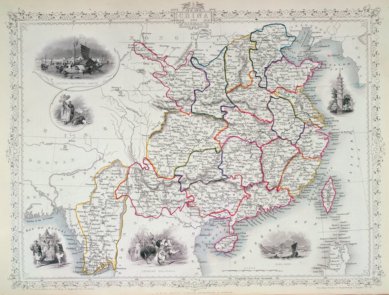
Map of China and Burma, 1851 by John Rapkin

Map of China and Burma, 1851

(Map of China and Birmah, 1851 (colour engraving))


John Rapkin

€ 116.48
Enthält 0% MwSt.
   Configure art print
1851  ·  colour engraving  ·  Picture ID: 78376

Nonclassified artists  ·  Cartography

Map of China and Burma, 1851 by John Rapkin. Available as an art print on canvas, photo paper, watercolor board, uncoated paper or Japanese paper.
cartography · mapping · geographical · east asia · yellow sea · canton · bay of bengal · hong kong · eastern sea · burma · pagoda · british factories · borders · asia · cartouche · asian · myanmar · geography · chinese · burmese · asian · Far East · Private Collection / Bridgeman Images
zu Favoriten hinzufügen   Add to favorites    Select wall color    View painting in a room AR/3D   View in 3D / AR
0 Reviews

Configure art print

Picture Frame

Medium & Stretcher

Glass & Passepartout

Miscellaneous & Extras

 Save / compare configuration
Preview Icon

Summary

Gemälde
Veredelung
Keilrahmen
Museumslizenz

€ 116.48
(inkl. 20% MwSt)
   Add to cart

Bildschärfe: PERFEKT

Should you desire adjustments to brightness and color, or a custom crop of the motif, we are happy to make these changes at no additional cost to you. Please do not hesitate to contact us.

Similar artworks selected for you

Map of Russia from: Imperii Russici et Tartariae Universae tam Majoris et Asiaticae quam Minoris et Map of Russia Map of Ireland from Champagne-Ardenne, Picardy, Lorraine, Franche-Comté, Burgundy, Île-de-France, France Map of Germany, Germania Antiqua, from Map of China Map of Voronezh Governorate Map of France Map of France at the times of King Charles VII and after the expulsion of the English between 1422 and 1461 (Plate from Houze Switzerland Turkey in Asia General Map of Kazan Governorate General Map of Kazan Governorate Governances of Anjou, Saumurois, Touraine and Poitou, Aunis and Saintonge with Anjoumois Sardinian States on the Mainland Map of China and Japan Map of France, Gallia Antique, from General Map Including Arabia, Japan, the Korean Peninsula and the Greater Part of the Indonesian Archipelago, 1631 Southern Scotland divided into its counties, engraving by G. Zuliani from Map of Independent Tartary Including the Lands of the Kalmyks, Uzbeks, and Turkestan Gaul divided into Roman provinces - Plate extracted from General Map of European Russia and the Caucasian Countries Map of the Province of Namur (Belgium) (engraving) Map of Mongolia showing Japan and China, c.1680 by Frederick de Wit France and Spain (Regions and Communities) A New Geographical Pastime Exhibiting a Complete Tour Through France Respectfully Dedicated with Permission to the Right Honorable Lady Georgiana Cavendish Map of Russia and Poland Map of Russia and Poland Map of the Austrian Empire
Show more similar artworks

Other art prints by John Rapkin

Falkland Islands and Patagonia, from a Series of World Maps published by John Tallis and Co., New York and London, 1850s Eastern Hemisphere, from a Series of World Maps published by John Tallis and Co., New York and London Patagonia, from a Series of World Maps published by John Tallis und Co., New York and London, 1850s Map of China and Burma, 1851 Map of British America Nova Scotia and Newfoundland, from a Series of World Maps published by John Tallis und Co., New York and London, 1850s Van Diemen Australia, from a Series of World Maps Published by John Tallis and Co., London and New York, 1850s Part of South Australia, from a Series of World Maps published by John Tallis und Co, New York and London British Guyana, from a Series of World Maps published by John Tallis & Co., New York & London Polynesia or Islands in the Pacific Ocean, from a Series of World Maps by John Tallis and Co., New York and London, 1850s Overland Route to India New South Wales, from a Series of World Maps published by John Tallis & Co., London & New York Victoria or Port Phillip, Australia, from a Series of World Maps published by John Tallis & Co, New York & London Western Australia, from a Series of World Maps published by John Tallis & Co., London & New York
Discover more works by John Rapkin

Other motives from the category Cartography

A Map of Covent Garden and Westminster, London, 1746 Map of the Cape of Good Hope Map of the North Sea, c.1675 Map and Prospect of London, c.1710 Detailed map of Gallipoli Peninsula and the Dardanelles Turkey, from Partial Map of the Middle East Showing the Red Sea, Persian Gulf and Horn of Africa in the 1890s, from Map of the West Indies, Florida and South America Map of Raab, from Map of Mexico or New Spain, 1625 Photograph of a French Map Showing the Battlefields of Verdun, September 1916 Map of Palestine, from a Passover Haggadah, printed in 1695 Map of Luxembourg, from Map of Transylvania, from an atlas, Amsterdam, 1657 Map No.6 showing the route of the Armada fleet, engraved by Augustine Ryther, 1588 Sketch Map of India Illustrating the History from the Earliest Period to the Battle of Plassy
View More from "Cartography"

Excerpt from our top sellers

Angel Musician Boys Bathing Nocturne in Black and Gold, the Falling Rocket Poor Little Bear!, 1912 Whirl of Love After Sunset Starry Night, c.1850-65 The Apple Tree Watercolor No. 606 Tsuki Plain in Kai Province, from the series Thirty-six Views of Mount Fuji Irises Silent Night Vassilissa in the Forest, illustration from the Russian folk tale, Joan of Arc, 1865 The Zaporozhye Cossacks Writing a Letter to the Turkish Sultan
Show More Artworks


What our customers think about us


Frequently Asked Questions about Meisterdrucke


Personalizing your art print at Meisterdrucke is a simple and intuitive process that allows you to design an artwork exactly to your specifications: Choose a frame, determine the image size, decide on a printing medium, and add suitable glazing or a stretcher frame. We also offer customization options such as mats, fillets, and spacers. Our customer service is available to help you design your perfect artwork.

At Meisterdrucke, you have the fascinating option to visualize the artwork you configured directly in your own space. For a tailored preview, simply upload a photo of your room and let the artwork appear on it. If you visit us via a mobile device, be it a phone or tablet, our augmented reality feature brings the image to life and seamlessly projects it into your space. An experience that uniquely combines art and technology.

Choosing the medium is often a matter of personal taste. To give you a clearer idea, we have provided some images for each medium. For a holistic experience, we also offer you a sample set of all paper variants so you can make a decision not just visually but also haptically. You can take advantage of the sample set free of charge – only the shipping costs will apply. You can order the sample set directly.

Do not worry. At Meisterdrucke, we do not proceed mechanically. We manually review each order. If there are any inconsistencies or peculiarities in the configuration, we will immediately contact you. Of course, our courteous and patient support is always at your side to assist you with the configuration. Together with you, we adjust your image by phone or email so that the final result exactly meets your expectations.


Do you have any questions?

Are you interested in an art print from our manufactory but still unsure? Do you need advice on choosing the medium or help with the order?

Our experts are happy to assist you.

+43 4257 29415
support@meisterdrucke.com
Mo-Do: 7:00 - 16:00 | Fr: 7:00 - 13:00

Do you have any questions?

Are you interested in an art print from our manufactory but still unsure? Do you need advice on choosing the medium or help with the order?

Our experts are happy to assist you.

+43 4257 29415
support@meisterdrucke.com
Mo-Do: 7:00 - 16:00 | Fr: 7:00 - 13:00


Meisterdrucke

   Kärntner Strasse 46
        9586 Finkenstein am Faaker See
        Austria
        +43 4257 29415
        support@meisterdrucke.com
Other languages

                   
Erfahrungen & Bewertungen zu Meisterdrucke
Partner Logos

Kaiser Franz Joseph

Meisterdrucke
Kärntner Strasse 46
9586 Finkenstein am Faaker See · Austria
+43 4257 29415 · office@meisterdrucke.com
Partner Logos


(c) 2025 meisterdrucke.us