-
 ×
×
- Home
- Art Prints ▸
- Artists ▸
- Categories ▸
- Art Styles ▸
-
Picture Frame ▸
- All decorative frames
- Baroque decorative frames
- Simple decorative frames
- Rustic decorative frames
- Floating frames
- Golden decorative frames
- Silver decorative frames
- White decorative frames
- Black decorative frames
- Wood-look decorative frames
- Shabby chic decorative frames
- Thin decorative frames
- Thick decorative frames
-
Print Media ▸
- All print media
- Canvas Leonardo (satin)
- Canvas Salvador (matte)
- Canvas Raphael (matte)
- FineArt Photo Matte
- FineArt Photo Satin
- FineArt Photo Baryte
- FineArt Photo Glossy
- Watercolor Paper Munch
- Watercolor Paper Renoir
- Watercolor Paper Turner
- Watercolor Paper Dürer
- Natural Line Hemp
- Natural Line Rice
- Kozo White, 110g
- Kozo Natural, 110g
- Inbe White, 125g
- Unryu, 55g
- Bamboo, 110g
- Premio Unryu, 165g
- Murakumo Natural, 42g
- Bizan Natural, 300g
- Bizan White, 300g
- Aluminum composite 3mm
- Acrylic glass 5mm
- Order Sample Set
- Which print medium is right for you?
Canvas
Photo Paper
Watercolor Board
Natural Line
Japanese Paper
Special Media
More information
-
Help & Service ▸
- Contact us
- Sell your art
- Frequently Asked Questions
- Job Openings
- Complaint
- Order Samples
- Order Vouchers
- Shipping costs
- Production time
- Sustainability
- Image research
- Special requests
- Who are we?
- Pricing policy
- Company policy
- Quality promise
- Stretcher frame
- Mats
- Decorative frames
- Glazing
- Fillets
- Mounting systems
- Print media
- Care tips
- Legal Notice
- Terms & Conditions
- Privacy Policy
- Right of Cancellation
Info & Service
More information
Good to know
Legal information
- Shop ▸
- Contact
")
.jpg)
.jpg)
.jpg)
.jpg "Siege of Saint-Omer")
.jpg "Valloton")
_-_(MeisterDrucke-1515060).jpg "A Map of the Country and City of Panama. Part. 3 : Chap : 5. (engraving)")
.jpg "Map of the Battle of Landen")
.jpg "The Principality of Orange and Comtat Venaissin")
.jpg "Map of Northern Norway with Enlarged Sections of Vardø and Kildin by Willem Barents")
.jpg "Plan of the Glorious Action Near Pultawa in Ukraine Between the Armies of Tsar Peter the Great of Russia and King Charles XII of Sweden, June 27 - July 8, 1709")
.jpg "A coloured chart of Plymouth Harbour, and of the country up to Tavistock; drawn possibly by Robert Spry")
.jpg "Map of Chile Compiled by Jesuits")
.jpg "Project for the construction of a channel of communication between the Atlantic Ocean and the Mediterranean Sea, including part approximately between Toulouse and Pexiora; in the regions of Midi-Pyrenees and Languedoc-Roussillon, France")
.jpg "French Guiana, South America")
.jpg "Project for the construction of a channel of communication between the Atlantic ocean and the Mediterranean sea, inclusive part approximately between Capestang and Étang de Thau; in the regions of Languedoc-Roussillon, France")
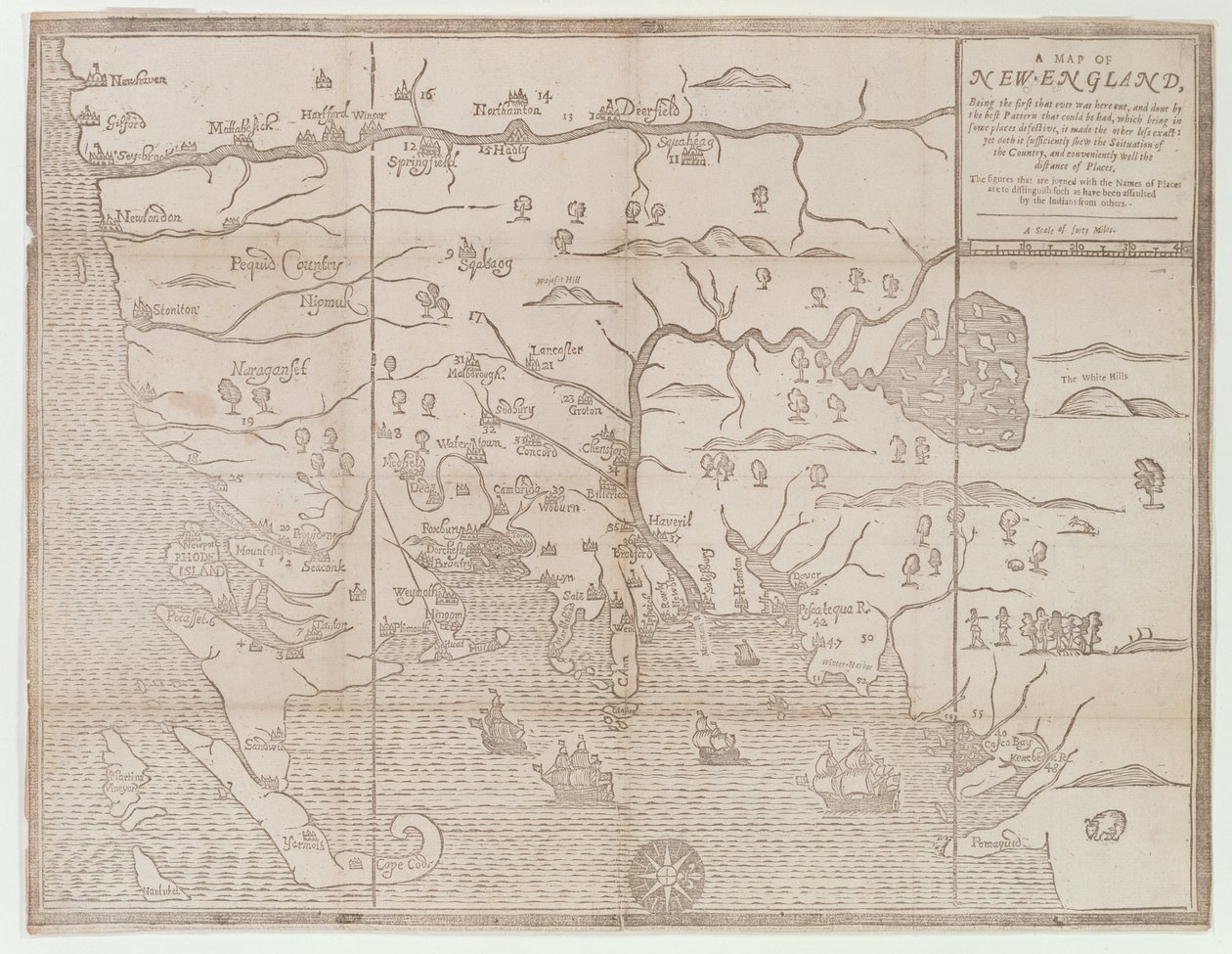
_-_(MeisterDrucke-1087495).jpg "Connecticut")
.jpg "Louis XIV Atlas, map of Collioure")
.jpg "Map of the Canal du Midi, with its aqueducts")
.jpg "Battle of Ter won by the King")
_from_Travel_account_-_(MeisterDrucke-1123712).jpg "City of Goa in India, Engraving by Theodor de Bry from Travel account of the voyage of the sailor Jan Huyghen van Linschoten to Portuguese East India 1579-1592")
.jpg "Speculum Romanae Magnificentiae: Ancient Rome, and its Hills, from the West, 1582")
.jpg "Allegorical Map of the Stages of Love")
.jpg "1646 Map of the Western Mediterranean and Gibraltar by Robert Dudley")
.jpg "Chart of the North Sea dedicated to")
.jpg "True Design of the Great Victory Against the Turkish Fleet, May 15, 1649")
.jpg "Toulon, France")
_-_(MeisterDrucke-1353072).jpg "The English Victory Against the Scots at Muskelbroghe, 1547")
_-_(MeisterDrucke-1351424).jpg "The Battle of Pinkie, c.1547-48")
_(Engraving_-_(MeisterDrucke-971666).jpg "Map of Toulon (France)")
.jpg "Map of the Canal du Midi, with its aqueducts")
.jpg "Smyrna")
.jpg "Temple of Theseus, Athens")
.jpg "The East End and South Side of the Parthenon")
.jpg "The Hippodrome, Constantinople")
.jpg "General View of the Temple of Apollo Epicurius at Bassai, Phigalea")
 - (MeisterDrucke-58602).jpg "The East End and South Side of the Parthenon, c.1813")
.jpg "The Temple of Apollo Epicurius at Bassai, Phigalea")
.jpg "Temple of Jupiter, Athens")
.jpg "Richard Mather, First in a Line of New England Puritan Clergymen and Leader of New England Congregationalism")
.jpg "Map of Cornwall from the")
 - (MeisterDrucke-104412).jpg "Map of the Moluccas, 1522")
 - (MeisterDrucke-75897).jpg "Map of the Siege of York in 1781, from")
.jpg "Map of the Sea of Maluku, from the Cosmographie Universelle")
.jpg "Fol.13 Map of South America and the Magellan Straits, from an Atlas, 1571")
.jpg "A Map of Bloomsbury and Holborn, London")
_and_Frans_-_(MeisterDrucke-226837).jpg "Map of Ostia, from")
.jpg "Map of the Races of Oceania and Australasia, from")
.jpg "Map of the Strait of Magellan, plate from Oliver van Noort")
_and_Frans_H_-_(MeisterDrucke-199733).jpg "Map of Rome, from")
.jpg "Map of the United States in 1861, from")
.jpg "Map of the Battle of Trafalgar, published by William Blackwood and Sons, Edinburgh and London")
.jpg "Map of the Bay of Bengal, the China Sea and Java")
_across_Siberia_to_Kamchatka_f_-_(MeisterDrucke-426959).jpg "Map of the route taken by Vitus Bering across Siberia to Kamchatka, from Navigantium atque Itinerantium Bibliotheca published 1744")
.jpg "Map of Asia, Tartaria, Japan, the Philippines and the East Indies, engraved by G. van Gouwen, c.1690")
.jpg "Pear Blossom, 1882")
 - (MeisterDrucke-24372).jpg "Autumn Tree in Stirred Air (Winter Tree)")
.jpg "Girl with a Rake in Fjord Landscape")
.jpg "Several Circles")
.jpg "A Luncheon. The Artist, His Wife and the Writer Otto Benzon")
.jpg "Sadko")
_-_(MeisterDrucke-94080).jpg "Head of a Young Woman with Tousled Hair or, Leda")
.jpg "The Water Lily Pond, Evening")
.jpg "Silent Night")
 from Choix des Plus Belles Fleur - (MeisterDrucke-248643).jpg "Rosa banksiae (Banks")
.jpg "Mona Lisa")
.jpg "Death and Life, c.1911")
.jpg "Nude in an Interior")
.jpg "Poster for the 1936 Olympic Games, Berlin")
.jpg "Saint Michael the Archangel")


