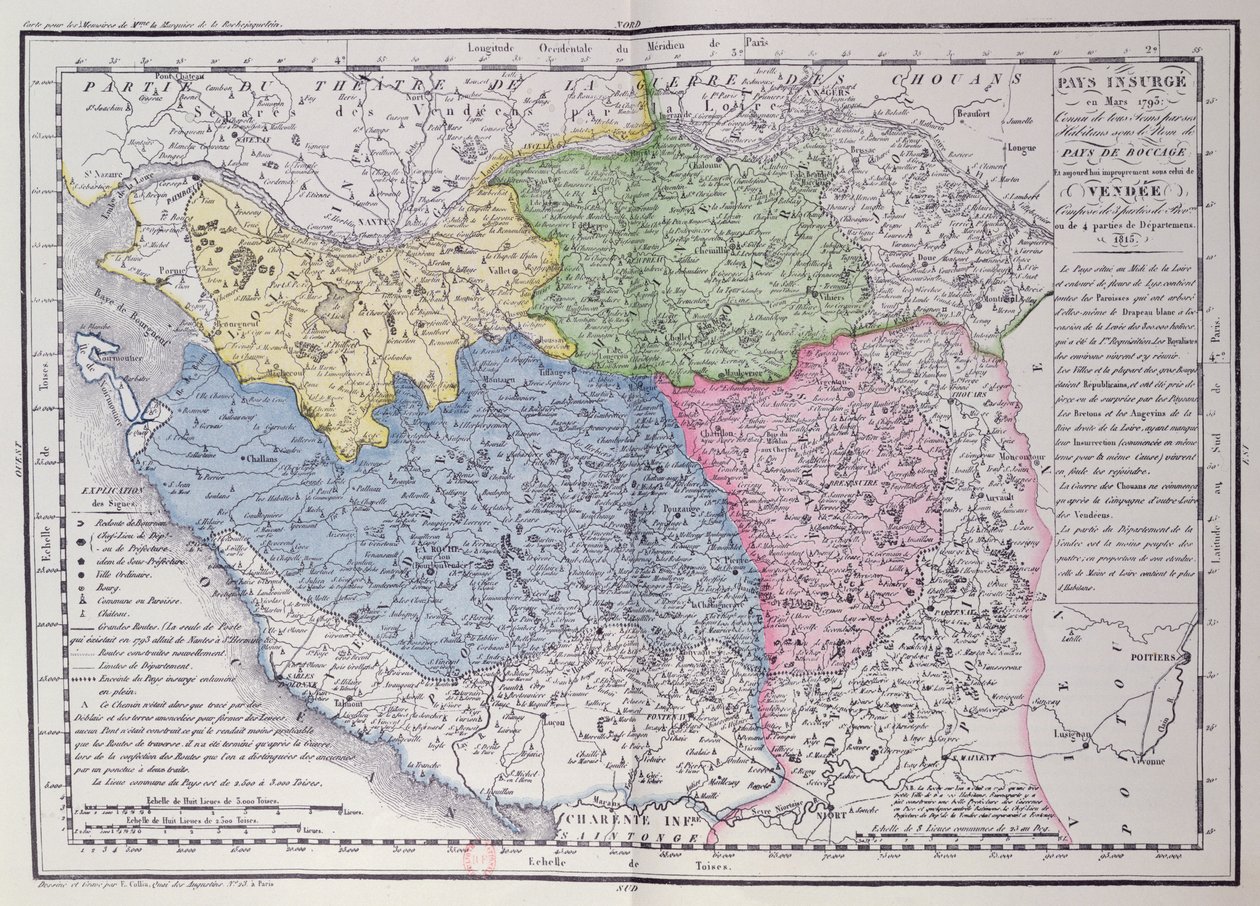
Map of the Vendee Depicting the Area of the Vendean Revolt (1793-96) in March 1793 by F. Colliu

Map of the Vendee Depicting the Area of the Vendean Revolt (1793-96) in March 1793

(Map of the Vendee depicting the area of the Vendean Revolt (1793-96) in March 1793,c.1815 (colour engraving))


F. Colliu

€ 118.92
Enthält 0% MwSt.
   Configure art print
1815  ·  colour engraving  ·  Picture ID: 362520

Nonclassified artists  ·  Cartography

Map of the Vendee Depicting the Area of the Vendean Revolt (1793-96) in March 1793 by F. Colliu. Available as an art print on canvas, photo paper, watercolor board, uncoated paper or Japanese paper.
royalist · insurgency · boccage · Bibliotheque Nationale de Cartes et Plans, Paris, France / Bridgeman Images
zu Favoriten hinzufügen   Add to favorites    Select wall color    View painting in a room AR/3D   View in 3D / AR
0 Reviews

Configure art print

Picture Frame

Medium & Stretcher

Glass & Passepartout

Miscellaneous & Extras

 Save / compare configuration
Preview Icon

Summary

Gemälde
Veredelung
Keilrahmen
Museumslizenz

€ 118.92
(inkl. 20% MwSt)
   Add to cart

Bildschärfe: PERFEKT

Should you desire adjustments to brightness and color, or a custom crop of the motif, we are happy to make these changes at no additional cost to you. Please do not hesitate to contact us.

Similar artworks selected for you

Trans-Island Territory by Barthold Wicheringe Map of Persia South-West Turkmenistan, Iran, West Afghanistan, West Pakistan A New Map of Turkey in Asia Map of the Flanders Campaign Between French Army and Austrian Army Map of the Kingdom of Hungary and the States which are United to its Crown, pub. by Jan Barend Elwe, Amsterdam, 1742 Map of the Kingdom of Hungary (etching) Gaul divided into Roman provinces - Plate extracted from Land Map of the Electorate of Brandenburg with Royal Prussian Privilege Map of Silesia, from an Atlas Map of Persia Map of the Byzantine Empire during the occupation of Bulgarians and Italy during the reign of Otto I, Otto II and Otto III Turkey in Asia Map of Independent Tartary Including the Lands of the Kalmyks, Uzbeks, and Turkestan Map of Germany, Germania Antiqua, from The Kingdom of Bohemia, Duchy of Silesia, Marquisate of Moravia and Lusatia Map of France, Gallia Antique, from Large Part of Croatia, Bosnia and Herzegovina, Serbia and Montenegro, Large Part of Bulgaria, South Ukraine, Moldova, Romania, South Slovakia, Hungary Alsatia, Germany (engraving) Hungarian War Theatre Geographical Map of the Theatre of War, Showing the Kingdom of Hungary in the Main, 1771 Electorate of Hanover Map of the Swiss Federation (etching) Kingdom of Gallaecia Map of Central Asia Aquitaine, Midi-Pyrenees, Languedoc-Roussillon, France Map of Armenia, Colchis, Iberia and Albania, from Map of Northern Germany, from an Atlas Map of the South West of Île-de-France
Show more similar artworks

Other motives from the category Cartography

Map of the Magellan Straits, Patagonia Map of Central Europe, from the Map of Central Europe, from Map of the United States, 1816 Maps of Africa, Upper Guinea, and the Gold Coast, Showing the Site of the Ashantee War Map of Australia, from A Map of Shoreditch and Whitechapel, London, 1746 Map of the Bay of Bengal, the China Sea and Java Map of Laos and the Mekong River Showing the Route of the Voyage of Henri Mouhot, Illustration from Travels in the Central Parts of Indo-China (Siam), Cambodia, and Laos During the Years 1858, 1859 Map of New Belgium with a View of New Amsterdam, compiled by Nicolaes Visscher c.1651-55 Double Hemisphere World Map, 1587 Map of Sixteenth Century Scandinavia, from the A Map of the Countries Thirty Degrees round the North Pole, from Civil War Map of General Sherman Map of Europe, illustration from Le Magasin Pittoresque, 1849
View More from "Cartography"

Excerpt from our top sellers

The Disciples Peter and John Running to the Sepulchre on the Morning of the Resurrection Poster advertising Cat in a Rainbow Vertumnus A Luncheon. The Artist, His Wife and the Writer Otto Benzon Wiltshire Landscape, 1937 Still Life: Vase with Cornflowers and Poppies Fir Forest I Starry Night Lovers of the Sun The Redoutable at Trafalgar, 21st October 1805 The Mountain Mowers, First Version Under the Wave off Kanagawa Cat Circe
Show More Artworks


What our customers think about us


Frequently Asked Questions about Meisterdrucke


Personalizing your art print at Meisterdrucke is a simple and intuitive process that allows you to design an artwork exactly to your specifications: Choose a frame, determine the image size, decide on a printing medium, and add suitable glazing or a stretcher frame. We also offer customization options such as mats, fillets, and spacers. Our customer service is available to help you design your perfect artwork.

At Meisterdrucke, you have the fascinating option to visualize the artwork you configured directly in your own space. For a tailored preview, simply upload a photo of your room and let the artwork appear on it. If you visit us via a mobile device, be it a phone or tablet, our augmented reality feature brings the image to life and seamlessly projects it into your space. An experience that uniquely combines art and technology.

Choosing the medium is often a matter of personal taste. To give you a clearer idea, we have provided some images for each medium. For a holistic experience, we also offer you a sample set of all paper variants so you can make a decision not just visually but also haptically. You can take advantage of the sample set free of charge – only the shipping costs will apply. You can order the sample set directly.

Do not worry. At Meisterdrucke, we do not proceed mechanically. We manually review each order. If there are any inconsistencies or peculiarities in the configuration, we will immediately contact you. Of course, our courteous and patient support is always at your side to assist you with the configuration. Together with you, we adjust your image by phone or email so that the final result exactly meets your expectations.


Do you have any questions?

Are you interested in an art print from our manufactory but still unsure? Do you need advice on choosing the medium or help with the order?

Our experts are happy to assist you.

+43 4257 29415
support@meisterdrucke.com
Mo-Do: 7:00 - 16:00 | Fr: 7:00 - 13:00

Do you have any questions?

Are you interested in an art print from our manufactory but still unsure? Do you need advice on choosing the medium or help with the order?

Our experts are happy to assist you.

+43 4257 29415
support@meisterdrucke.com
Mo-Do: 7:00 - 16:00 | Fr: 7:00 - 13:00


Meisterdrucke

   Kärntner Strasse 46
        9586 Finkenstein am Faaker See
        Austria
        +43 4257 29415
        support@meisterdrucke.com
Other languages

                   
Erfahrungen & Bewertungen zu Meisterdrucke
Partner Logos

Kaiser Franz Joseph

Meisterdrucke
Kärntner Strasse 46
9586 Finkenstein am Faaker See · Austria
+43 4257 29415 · office@meisterdrucke.com
Partner Logos


(c) 2025 meisterdrucke.us