support@meisterdrucke.com  ·  0043 4257 29415

Deutsch English Italiano Español Français Nederlands Português Svenska Polski Dansk
Search by artist, work title or style – e.g. Monet, Starry Night, Impressionism, Hokusai wave, nude. Describe the scene – e.g. green meadow, abstract with lots of red, dark oil painting, standing nude next to a tree.

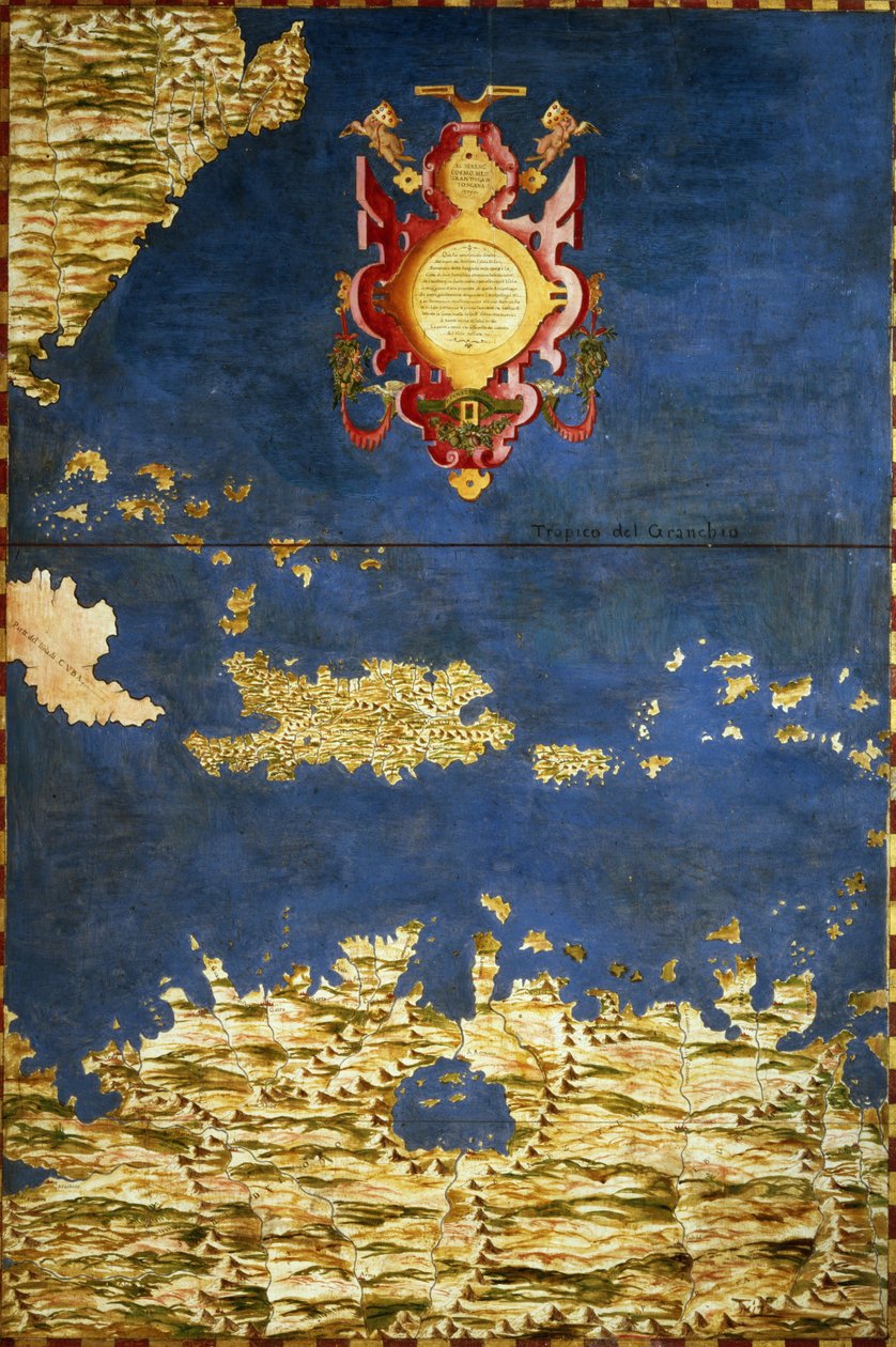
Map of the Caribbean and Venezuela, from the 'Sala delle Carte Geografiche' (Hall of Geographical Maps), c. 1570 by Ignazio Danti

Map of the Caribbean and Venezuela, from the 'Sala delle Carte Geografiche' (Hall of Geographical Maps), c. 1570

(Map of the Caribbean and Venezuela, from the 'Sala delle Carte Geografiche' (Hall of Geographical Maps) c.1570 )


Ignazio Danti

€ 137.53
Tax-free
   Configure art print
Undated  ·  oil on wood  ·  Image ID: 281765

Nonclassified artists  ·  Cartography

Map of the Caribbean and Venezuela, from the 'Sala delle Carte Geografiche' (Hall of Geographical Maps), c. 1570 by Ignazio Danti. Available as an art print on canvas, photo paper, watercolor board, natural paper, or Japanese paper.
cartography · cartouche · puerto rico · cuba · jamaica · dominican republic · haiti · Palazzo Vecchio (Palazzo della Signoria) Florence, Italy / Bridgeman Images
Other color versions of this image  
AR/3D   View in 3D / AR zu Favoriten hinzufügen   Add to favorites    Change wall color    View picture in a room
0 Reviews

Configure art print

Picture Frame

Medium & Stretcher

Glass & Passepartout

Miscellaneous & Extras

 Save / compare configuration
Preview Icon

Summary

Gemälde
Veredelung
Keilrahmen
Museumslizenz

€ 137.53
(inkl. 20% MwSt)
   Add to cart

Bildschärfe: PERFEKT

If you'd like us to adjust the brightness, colors, or crop the image, we're happy to do this for you at no extra cost. Just get in touch!

Similar artworks selected for you

Santo Domingo or Hispaniola. Map made by Egnazio Danti (1536-1586), Italian mathematician, cosmographer and architect. Around 1567. Florence, Palazzo Vecchio, Sala del Mappamondo Haiti, Dominican Republic, Puerto Rico and French West Indies Molucca Islands and Part of the Philippines Map of the Molucca Islands made by Egnazio Danti (1536-1586), Italian mathematician, cosmographer and architect. Around 1567. Florence, Palazzo Vecchio, Sala del Mappamondo Shore of China and Japan Indonesia: Sumatra, Malacca, Borneo, Java. Map made by Egnazio Danti (1536-1586), Italian mathematician, cosmographer and architect. Around 1567. Florence, Palazzo Vecchio, Sala del Mappamondo Indochinese Peninsula and Major Islands of Indonesia Greenland Map of China and Japan made by Egnazio Danti (1536-1586), an Italian mathematician, cosmographer and architect. Around 1567. Florence, Palazzo Vecchio, Sala del Mappamondo. Middle East: Georgia, Armenia, Azerbaijan, Iraq, Western Iran Map of Armenia made by Egnazio Danti (1536-1586), mathematician, cosmographer and Italian architect. Around 1567. Florence, Palazzo Vecchio, Sala del Mappamondo Map of Mexico and Central America Middle East: Georgia, Armenia, Iraq, Western Iran Madagascar Map of the Philippines, from the Mexico, Cuba, Florida and Jamaica. Map made by Egnazio Danti (1536-1586), Italian mathematician, cosmographer and architect. Around 1567. Florence, Palazzo Vecchio, Sala del Mappamondo Map of Anatolia made by Egnazio Danti (1536-1586), an Italian mathematician, cosmographer and architect. Around 1567. Florence, Palazzo Vecchio, Sala del Mappamondo. Ecuador and Peru Map of India made by Egnazio Danti (1536-1586), Italian mathematician, cosmographer and architect. Around 1567. Florence, Palazzo Vecchio, Sala del Mappamondo Moscow region map by Egnazio Danti (1536-1586), mathematician, cosmographer and Italian architect. Around 1567. Florence, Palazzo Vecchio, Sala del Mappamondo Map of Cuba and the Caribbean Chile and Argentina with the Strait of Magellan Map of Sixteenth Century Turkey, from the Map of the Bay of Bengal, the China Sea and Java Map of Anatolia made by Egnazio Danti (1536-1586), an Italian mathematician, cosmographer and architect. Around 1567. Florence, Palazzo Vecchio, Sala del Mappamondo. Map of China Russia Map of Armenia
Show more similar artworks

More art prints by Ignazio Danti

California Galleon, detail from the Battle of Lepanto (1571) Great Britain and Ireland Map of Mexico and Central America, from the Map of the Caribbean and Venezuela, from the Map of India and Ceylon, from the Bologna, detail from the “Galleria delle Carte Geografiche”, 1580-83 The Tyrrhenian Sea, detail from the ’Galleria delle Carte Geografiche’, 1580-83 Map of Brazil, from the “Sala delle Carte Geografiche” (Hall of Geographical Maps), c.1570 Venice, detail from the The Scandinavian peninsula Gulf of Mexico, Cuba and Southern United States South Africa, Mozambique and Part of Madagascar A galleon in the Adriatic (detail)
Show more works by Ignazio Danti

More motifs from the category Cartography

Map of Central Europe, from Map of Bristol, from ’Civitates Orbis Terrarum’ by Georg Braun (1541-1622) and Frans Hogenberg (1535-90), c. 1572-1617 Map of Phillipsburg, from World Map, early 18th century Map of the return of the 8th Crusade in 1270 with the resting places of Louis IX Map of East Africa and Madagascar, 1596 Cartouche of Quebec from “Carte de l Map of Asia, published in 1700, Paris Map of Asia, Tartaria, Japan, the Philippines and the East Indies, engraved by G. van Gouwen, c. 1690 A New and General Map of the Middle Dominion Belonging to the United States, 14th May 1794 Map of Seville, Cadiz, and Malaga, from Map of France depicting the departmental divisions, 1798 Map of Milan, from Civitates Orbis Terrarum by Georg Braun (1541-1622) and Frans Hogenburg (1535-90), c. 1572 Map of Aegyptus Antiqua (Ancient Egypt), drawn and engraved by Sydney Hall, c. 1826 Map of Toledo and Valladolid, from ’Civitates Orbis Terrarum’ by Georg Braun (1541-1622) and Frans Hogenberg (1535-90), c. 1572
View More from "Cartography"

A selection of our top sellers

Ophelia The Attic Room The Carpet Merchant Olive Trees in the Moreno Garden, 1884 Castle and Sun Noonday Heat Danaë, 1907 Yellow - Red - Blue Kanchenjunga, 1936 Roller-Skating Club Around Alexanderplatz The Red Pines, 1888 Witches The Letter Carrier in Rosenthal Irises Boy Writing with His Sister, 1875
Show more artworks


What our customers think about us


Frequently Asked Questions about Meisterdrucke


Personalizing your art print at Meisterdrucke is simple and intuitive: Choose a frame, set the image size, pick a printing medium, and add suitable glazing or a stretcher frame. We also offer additional customization options like mats, fillets, and spacers. If you have any questions, our customer service team is ready to help you create your perfect artwork.

At Meisterdrucke, you can visualize your configured artwork directly in your own room. Simply upload a photo of your space and see how the artwork looks in it. If you're visiting us on a mobile device — phone or tablet — our augmented reality feature brings the picture to life and projects it right into your room. A unique experience that combines art and technology.

Choosing the right medium is often a matter of personal taste. To give you a better idea, we've provided some images for each medium. We also offer a sample set of all paper variants, so you can decide not just visually but by touch as well. You can order the sample set free of charge — only shipping costs apply.

Don't worry! At Meisterdrucke, we don't just process orders mechanically. Every order is manually reviewed by our team. If we spot any inconsistencies or issues with your configuration, we'll get in touch with you right away. And of course, our friendly and patient support team is always here to help you with your configuration. We'll work with you by phone or email to adjust your image so the final result is exactly what you had in mind.


Still have questions?

Are you interested in an art print from our manufactory but still unsure? Do you need advice on choosing the medium or help with the order?

Our experts are happy to assist you.

+43 4257 29415
support@meisterdrucke.com
Mo-Do: 7:00 - 16:00 | Fr: 7:00 - 13:00

Still have questions?

Are you interested in an art print from our manufactory but still unsure? Do you need advice on choosing the medium or help with the order?

Our experts are happy to assist you.

+43 4257 29415
support@meisterdrucke.com
Mo-Do: 7:00 - 16:00 | Fr: 7:00 - 13:00


Meisterdrucke

   Kärntner Strasse 46
        9586 Finkenstein am Faaker See
        Austria
        +43 4257 29415
        support@meisterdrucke.com
Other languages

                   
Erfahrungen & Bewertungen zu Meisterdrucke
Post.at DHL Express Quehenberger Cargoboard
Kaiser Franz Joseph

Meisterdrucke
Kärntner Strasse 46
9586 Finkenstein am Faaker See · Austria
+43 4257 29415 · support@meisterdrucke.com
Post.at DHL Express Quehenberger Cargoboard


(c) 2026 meisterdrucke.us