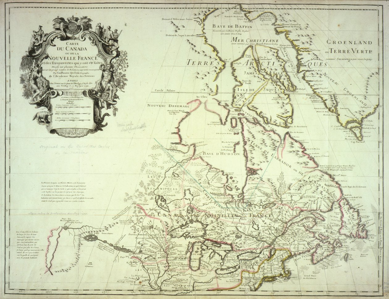
Map of Canada, Published Paris, 1703 by Guillaume Delisle

Map of Canada, Published Paris, 1703

(Map of Canada, published Paris, 1703 (hand-coloured engraving))


Guillaume Delisle

€ 115.71
Enthält 0% MwSt.
   Configure art print
1703  ·  hand-coloured engraving  ·  Picture ID: 148735

Nonclassified artists  ·  Cartography

Map of Canada, Published Paris, 1703 by Guillaume Delisle. Available as an art print on canvas, photo paper, watercolor board, uncoated paper or Japanese paper.
discoveries · greenland · arctic region · polar map · guillaume de lisle · hudson bay · baffin bay · labrador · mapping · cartography · cartouche · canada · canadian · Newberry Library, Chicago, Illinois, USA / Bridgeman Images
AR/3D   View in 3D / AR zu Favoriten hinzufügen   Add to favorites    Select wall color    View painting in a room
0 Reviews

Configure art print

Picture Frame

Medium & Stretcher

Glass & Passepartout

Miscellaneous & Extras

 Save / compare configuration
Preview Icon

Summary

Gemälde
Veredelung
Keilrahmen
Museumslizenz

€ 115.71
(inkl. 20% MwSt)
   Add to cart

Bildschärfe: PERFEKT

Should you desire adjustments to brightness and color, or a custom crop of the motif, we are happy to make these changes at no additional cost to you. Please do not hesitate to contact us.

Similar artworks selected for you

Canada Ontario, Quebec, Nova Scotia, New Brunswick, Manitoba, Nunavut, Prince Edward Island, Newfoundland and Labrador, Canada, Greenland Map of Canada and Greenland Hudson Bay, Land of Labrador and Greenland, engraving by G. Zuliani from Russian Lapland with Governments of Olonecholi, Carelia, Bielozero and Ingria in European Russia, from Tome III of the North America A Map of the British and French Dominions in America An Account of the New Northern Archipelago Lately Discovered by the Russians A commercial map of Scotland with the roads, stages and distances Kingdom of Scotland A new Chart of the Sea Coasts of France, together with the English Channel Land of the Ottawa and Kilistine Indians Around Lake Superior and a Supplement of Eastern Florida, Engraving by G. Zuliani from Tome I of the "Newest Atlas" Chart showing discoveries of Ross, Parry and Franklin in the Arctic during 1818-1827 Valencia and Castile, Spain Route from Brest to the Kingdom of Siam Sweden divided into its Kingdoms, engraving by G. Zuliani from The islands of Newfoundland and Cape Breton, engraving by G. Zuliani from The Kingdoms of Sweden, Denmark and Norway, Engraving by G. Zuliani from Tome III of the "Newest Atlas" A Map of Nova Scotia Frontispiece map from Map of the Irtysh River, the Southern Part of the Siberian Governorate Map of the Region of East Canada, East United States, Mexico, Guatemala, El Salvador, Belize, Honduras, Nicaragua, Costa Rica, Panama, Antigua and Barbuda, The Bahamas, Barbados, Cuba, Dominica, Jamaica, Grenada, Haiti, Dominican Republic, Saint Kitts and Nevis, Saint Lucia Land Area of the State of the Veneto, Divided into Its Provinces, Engraving by G. Zuliani from the Newest Atlas Sweden, Norway, Finland, Estonia, Russia East Europe, Asia and north Africa - by A Map of Central and North America, Published in 1700, Paris New Drawing of the Island of Rügen and the Stralsund as well as the City of Stralsund and the New Deep with All Its Situations in Large with Privilege The Philippines, Formosa, South China, the Kingdoms of Tonkin, Cochin China, Cambodia, Siam, Laos, and Part of Those of Pegu and Ava
Show more similar artworks

Other art prints by Guillaume Delisle

Map of Africa, Published in 1700, Paris Map of Europe, Published in 1700, Paris Map of North Africa and Europe Map of Italy, with Corsica, Sardinia and Sicily Map of Tartaria (Central Asia, Siberia, Turkestan, Mongolia and Manchuria) Map of Egypt, Nubia (Sudan) and Abyssinia (Ethiopia) Map of Mexico and Florida with the Caribbean Islands (Cuba, Haiti, Jamaica, Antilles) (etching) Map of neighboring countries of the Caspian Sea (Russia, Armenia, Persia, Kazakhstan, Turkmenistan) Map of South America, published in 1700, Paris Map of Southern Italy, Corsica, and Sardinia Known in Ancient Times as Great Greece or Magnia Graecia Map of North America Map of Asia, Published in 1700, Paris Map of the Iberic Peninsula, Kingdom of Portugal and Spain Map of Barbaria (Morocco, Algeria, Tunisia, Libya), Nigritude (Mali, Burkina Faso, Niger) and Guinee (Senegal, Guinea, Sierra Leone, Liberia, Ivory Coast, Ghana, Togo, Benin, Nigeria) (etching) Map of the Nordic countries, kingdoms of Denmark, Sweden and Norway
Discover more works by Guillaume Delisle

Other motives from the category Cartography

Map of Iceland Map of the city of Siam, capital of the kingdom of that name after a survey done by a French engineer in 1687, published in the 1751 edition of Histoire Generale des Voyages by Antoine Prevost Map of the United States in 1803, from Our Whole Country: The Past and Present of the United States, Historical and Descriptive, by John Warner Barber and Henry Hare, 1861 Map depicting North America as Divided by the European Powers, 1774 Map of Montpellier, from A New Map of the English Plantations in America Map of Asia, Tartaria, Japan, the Philippines and the East Indies, engraved by G. van Gouwen, c.1690 Map of Britain in 634, from Map of Central America Jerusalem and Damascus (detail) from a Renaissance map of Europe, 1528 Map of Laos and the Mekong River Showing the Route of the Voyage of Henri Mouhot, Illustration from Travels in the Central Parts of Indo-China (Siam), Cambodia, and Laos During the Years 1858, 1859 Map Illustrating La Rochelle Occupied by the Huguenots Map of France showing plans to divide Departments, 1789 Map of the Kingdom of Scotland, 17th century Scotia Regnum Map of Ancient Egypt
View More from "Cartography"

Excerpt from our top sellers

The Mountain Mowers, First Version P. Mønsted, Blooming Garden in Spring Mona Lisa Song of the Angels The Wild Hunt of Odin Rosa centifolia foliacea, from Les Roses, 1817-24 The Crucifixion, from the Isenheim Altarpiece The young Napoleon Bonaparte studying Noonday heat Sun Glitter Over the Sea, Skagen Vertumnus What Freedom! 1903 Madonna of the Yarnwinder Tierfabel: Tiger and Snake in Combat in a Primeval Forest The Greifswald Market
Show More Artworks


What our customers think about us


Frequently Asked Questions about Meisterdrucke


Personalizing your art print at Meisterdrucke is a simple and intuitive process that allows you to design an artwork exactly to your specifications: Choose a frame, determine the image size, decide on a printing medium, and add suitable glazing or a stretcher frame. We also offer customization options such as mats, fillets, and spacers. Our customer service is available to help you design your perfect artwork.

At Meisterdrucke, you have the fascinating option to visualize the artwork you configured directly in your own space. For a tailored preview, simply upload a photo of your room and let the artwork appear on it. If you visit us via a mobile device, be it a phone or tablet, our augmented reality feature brings the image to life and seamlessly projects it into your space. An experience that uniquely combines art and technology.

Choosing the medium is often a matter of personal taste. To give you a clearer idea, we have provided some images for each medium. For a holistic experience, we also offer you a sample set of all paper variants so you can make a decision not just visually but also haptically. You can take advantage of the sample set free of charge – only the shipping costs will apply. You can order the sample set directly.

Do not worry. At Meisterdrucke, we do not proceed mechanically. We manually review each order. If there are any inconsistencies or peculiarities in the configuration, we will immediately contact you. Of course, our courteous and patient support is always at your side to assist you with the configuration. Together with you, we adjust your image by phone or email so that the final result exactly meets your expectations.


Do you have any questions?

Are you interested in an art print from our manufactory but still unsure? Do you need advice on choosing the medium or help with the order?

Our experts are happy to assist you.

+43 4257 29415
support@meisterdrucke.com
Mo-Do: 7:00 - 16:00 | Fr: 7:00 - 13:00

Do you have any questions?

Are you interested in an art print from our manufactory but still unsure? Do you need advice on choosing the medium or help with the order?

Our experts are happy to assist you.

+43 4257 29415
support@meisterdrucke.com
Mo-Do: 7:00 - 16:00 | Fr: 7:00 - 13:00


Meisterdrucke

   Kärntner Strasse 46
        9586 Finkenstein am Faaker See
        Austria
        +43 4257 29415
        support@meisterdrucke.com
Other languages

                   
Erfahrungen & Bewertungen zu Meisterdrucke
Partner Logos

Kaiser Franz Joseph

Meisterdrucke
Kärntner Strasse 46
9586 Finkenstein am Faaker See · Austria
+43 4257 29415 · office@meisterdrucke.com
Partner Logos


(c) 2025 meisterdrucke.us