support@meisterdrucke.com  ·  0043 4257 29415

Deutsch English Italiano Español Français Nederlands Português Svenska Polski Dansk
Search by artist, work title or style – e.g. Monet, Starry Night, Impressionism, Hokusai wave, nude. Describe the scene – e.g. green meadow, abstract with lots of red, dark oil painting, standing nude next to a tree.

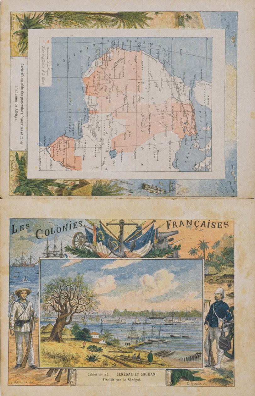
Map of French possessions and spheres of influence in Africa and a view of the Senegal River, cover of a school exercise book, late 19th century by G. Dascher

Map of French possessions and spheres of influence in Africa and a view of the Senegal River, cover of a school exercise book, late 19th century

(Map of French possessions and spheres of influence in Africa and a view of the river Senegal, cover of a school exercise book, late 19th century (colour engraving))


G. Dascher

€ 122.76
Tax-free
   Configure art print
Undated  ·  colour engraving  ·  Image ID: 154785

Nonclassified artists  ·  Cartography

Map of French possessions and spheres of influence in Africa and a view of the Senegal River, cover of a school exercise book, late 19th century by G. Dascher. Available as an art print on canvas, photo paper, watercolor board, natural paper, or Japanese paper.
colonies · colonial · imperialism · empire · france · african · colonisation · colony gal · Private Collection / Bridgeman Images
AR/3D   View in 3D / AR zu Favoriten hinzufügen   Add to favorites    Change wall color    View picture in a room
0 Reviews

Configure art print

Picture Frame

Medium & Stretcher

Glass & Passepartout

Miscellaneous & Extras

 Save / compare configuration
Preview Icon

Summary

Gemälde
Veredelung
Keilrahmen
Museumslizenz

€ 122.76
(inkl. 20% MwSt)
   Add to cart

Bildschärfe: PERFEKT

If you'd like us to adjust the brightness, colors, or crop the image, we're happy to do this for you at no extra cost. Just get in touch!

Similar artworks selected for you

French Guiana, South America Senegal, Mayotte, Ile de Sainte Marie, Nossi Be (Nossi-be or Nosy-be or Nosy be), Africa. Elephant, crocodile and boat in a river. Series on the French colonies. Chromolithography Map of Russia, Karta Rossii i plemena ee naseliaiushchiia American Islands in the North Ocean with Adjacent Lands Gabon, Tunisia and the Guinee Coast in Africa. Series on the French Colonies. Raw Material: Gum, Sponge, Tobacco and Silks, Ivory. Chromolithography Views of the Port of San Julian, Patagonia The Island of Jamaica 1743 map of West Africa Polish War, 1831 Scenes in England, Regency Era Wars of the Revolution: General Napoleon Bonaparte holding a map of Italy (at the time of the Italian Campaign) to complete the puzzle of the territories conquered by France. On the left, probably generals Hoche, Pichegru and Jean Victor Game of the Star-Spangled Banner or Emigrants to the United States No. 3--124885 The Debarkment of the Spanish Conquistadors Francisco Pizarro Map of America, Nova Totius Americae Tabula, with Views of Panama, Caput S. Augustini, Nieu Amsterdam, S. Salvador, Nombre D. Dios Map of the Mediterranean with allegorical figures and sea monsters embellishing the insets Map of Southern Russia with View of Sevastopol Bay and Its Fortifications Map of Southern Russia with View of Sevastopol Bay and Its Fortifications Map of Martinique created by Matthieu Seutter, details: Merchants and Native American Indian A chart of Guinea describing the sea coast from Cape de Verde to Cape Bona Esperanca Island of Crete The Semenovsky Life-Guards Regiment Western Front, World War One, September 25 The Siege of Kana by General Alfred-Amedee Dodds, 6th November 1892 (engraved by L. Geisler) In 1788 Mirabeau was already saying: "War is the national industry of Prussia" Map of Colonial Africa, from a school book, published in 1911 Map of Jamaica F.52v Map of Florida and the Antilles, from The Chinese Expedition into Tonkin, from
Show more similar artworks

More art prints by G. Dascher

Map of French possessions and spheres of influence in Africa and a view of the Senegal River, cover of a school exercise book, late 19th century Human sacrifices in Africa, c.1900 French Colonies, cover of an exercise book illustrated by G. Dascher The Exploration of M. de Brazza (1875-79), His Treaty with Makoko, illustration from Les Colonies Françaises Letters P Q and R: Post, Qui vive! and Officer Letters G H I: General, Hussard and Instructor. Engraving in "Alphabet militaire", Grand-Bebe series. Engraving. Pont-a-Mousson imaging. Louis Vagne, Printer-Publisher, circa 1900. Illustrations by G. Dascher 1789: Declaration of the Rights of Man and Citizen: The Right to Property. Engraving in 1789: Declaration of the Rights of Man and of the Citizen: National Sovereignty. Engraving in "The Single Book of Morals and Civic Instruction, Intended for Pupils in the Three Primary School Courses and Those in the Primary Classes of Lycées and Collèges" Village in Sudan, c.1900-1910 (illustration) Duties towards oneself: the body. Work and laziness The White Fathers of Cardinal Lavigerie in Africa 1789: Declaration of the Rights of Man and of the Citizen: Respect for the law. Engraving in ”Le livre unique de morale et d’instruction civique, destiné aux élèves des trois cours de l’École primaire et à ceux des classes primaires des Lycées et 1789: Declaration of the Rights of Man and of the Citizen: Equality. Engraving in Canaque village in New Caledonia, c.1900-1910 Norman ships besieging Paris, illustration from a cover of a school exercise book, late 19th century
Show more works by G. Dascher

More motifs from the category Cartography

Map of the Battles of Smolensk and Valtellina, published by William Blackwood and Sons, Edinburgh and London, 1848 Map of Charles V, map by Mecia de Viladestes, a portolan of Europe and North Africa, 1413 Map of the City and Portuguese Port of Goa, India, 1595 Map illustrating the Naval Attack on England by Napoleon Bonaparte (1769-1821), c. 1803-04 Insurance Map of the City of Philadelphia; volume 2, plate 15, 1887 City Map of Jerusalem in the 1890s, from Map No. 8 showing the route of the Armada fleet, engraved by Augustine Ryther, 1588 Map describing the islands of Salvador, Española, Fernanda, Isabella and Conception, 1493 Iceland, from an Atlas of the World in 33 maps, Venice, 1st September 1553 (detail from 330951) Map of Berlin showing buildings of interest, 1773 Map of New Belgium and New England, published in Amsterdam c.1640 ’Map of New England, Being the first that ever was here cut...’, 1677 Map of the City of New York, 1854 Map of Europe and Africa, from the ‘Sala del Mappamondo’ (Hall of the World Maps) Drawing for the map of the moon, 1794
View More from "Cartography"

A selection of our top sellers

Morning in a Pine Forest The Cactus Lover Delicate Tension No. 85, 1923 Birch tree Fir Forest I, 1901 Wheatfield View of El Castillo, 1844 The Convalescent, 1888 Standing Nude with Orange Drapery, 1914 The Boxer Dancers in blue, 1890 Saviour. From the Deesis tier A Bar Waterlilies: Morning, 1914-18 (left section) The Apparition
Show more artworks


What our customers think about us


Frequently Asked Questions about Meisterdrucke


Personalizing your art print at Meisterdrucke is simple and intuitive: Choose a frame, set the image size, pick a printing medium, and add suitable glazing or a stretcher frame. We also offer additional customization options like mats, fillets, and spacers. If you have any questions, our customer service team is ready to help you create your perfect artwork.

At Meisterdrucke, you can visualize your configured artwork directly in your own room. Simply upload a photo of your space and see how the artwork looks in it. If you're visiting us on a mobile device — phone or tablet — our augmented reality feature brings the picture to life and projects it right into your room. A unique experience that combines art and technology.

Choosing the right medium is often a matter of personal taste. To give you a better idea, we've provided some images for each medium. We also offer a sample set of all paper variants, so you can decide not just visually but by touch as well. You can order the sample set free of charge — only shipping costs apply.

Don't worry! At Meisterdrucke, we don't just process orders mechanically. Every order is manually reviewed by our team. If we spot any inconsistencies or issues with your configuration, we'll get in touch with you right away. And of course, our friendly and patient support team is always here to help you with your configuration. We'll work with you by phone or email to adjust your image so the final result is exactly what you had in mind.


Still have questions?

Are you interested in an art print from our manufactory but still unsure? Do you need advice on choosing the medium or help with the order?

Our experts are happy to assist you.

+43 4257 29415
support@meisterdrucke.com
Mo-Do: 7:00 - 16:00 | Fr: 7:00 - 13:00

Still have questions?

Are you interested in an art print from our manufactory but still unsure? Do you need advice on choosing the medium or help with the order?

Our experts are happy to assist you.

+43 4257 29415
support@meisterdrucke.com
Mo-Do: 7:00 - 16:00 | Fr: 7:00 - 13:00


Meisterdrucke

   Kärntner Strasse 46
        9586 Finkenstein am Faaker See
        Austria
        +43 4257 29415
        support@meisterdrucke.com
Other languages

                   
Erfahrungen & Bewertungen zu Meisterdrucke
Post.at DHL Express Quehenberger Cargoboard
Kaiser Franz Joseph

Meisterdrucke
Kärntner Strasse 46
9586 Finkenstein am Faaker See · Austria
+43 4257 29415 · support@meisterdrucke.com
Post.at DHL Express Quehenberger Cargoboard


(c) 2026 meisterdrucke.us