support@meisterdrucke.com  ·  0043 4257 29415

Deutsch English Italiano Español Français Nederlands Português Svenska Polski Dansk
Search by artist, work title or style – e.g. Monet, Starry Night, Impressionism, Hokusai wave, nude. Describe the scene – e.g. green meadow, abstract with lots of red, dark oil painting, standing nude next to a tree.

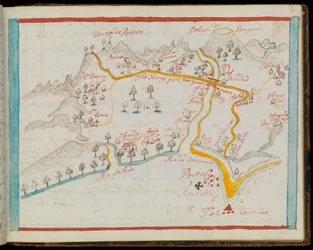
Map of the Coast of Africa and the River Gambia, 1622 by French School

Map of the Coast of Africa and the River Gambia, 1622

(Map of the Coast of Africa and the River Gambia, 1622 )


French School

€ 123.19
Tax-free
   Configure art print
1622  ·  coloured engraving  ·  Image ID: 520034

Cultural Circles  ·  Cartography

Map of the Coast of Africa and the River Gambia, 1622 by French School. Available as an art print on canvas, photo paper, watercolor board, natural paper, or Japanese paper.
senegal · senegalese · coast · coastal · africa · african · river gambia · village · villages · settlement · settlements · port · ports · birds eye view · rivers · French · Bibliotheque Nationale, Paris, France / Bridgeman Images
AR/3D   View in 3D / AR zu Favoriten hinzufügen   Add to favorites    Change wall color    View picture in a room
0 Reviews

Configure art print

Picture Frame

Medium & Stretcher

Glass & Passepartout

Miscellaneous & Extras

 Save / compare configuration
Preview Icon

Summary

Gemälde
Veredelung
Keilrahmen
Museumslizenz

€ 123.19
(inkl. 20% MwSt)
   Add to cart

Bildschärfe: PERFEKT

If you'd like us to adjust the brightness, colors, or crop the image, we're happy to do this for you at no extra cost. Just get in touch!

Similar artworks selected for you

Pascatway River in New England, c.1660-85 A coloured chart of Plymouth Harbour, and of the country up to Tavistock; drawn possibly by Robert Spry Map of the City of Jerusalem, from “Peregrinatio in Terram Sanctam” by Bernhard von Breydenbach (1440-97) Ireland State of Lucca, Italy Detail of Roman Gaul from the Peutinger map copy Harbor of Palos, by Abraham Ortelius (1528-1598), Plate The Course of the Rhine River in Westphalia, Germany Ile de France, North France The Carte du Tendre, a map of an imaginary country, from volume II of Map of Lower Egypt, from the Notebook of Sir Walter Raleigh, c.1606-08 Allegorical Map of the Stages of Love Sri Lanka (engraving) Theatrum Orbis Terrarum, 1570. Map of Western Andalusia by Abraham Ortelius and Jeronimo de Chaves Schleswig-Holstein, Germany Saxton Map of Southern Africa, published in Strasbourg in 1522 Terra Moriath Sive Solymarum Ager Suburbanus Port of Palos in Andalusia, from Theatrum Orbis Terrarum by Abraham Ortelius Map of Salzburg diocese, Austria, from Theatrum Orbis Terrarum Ms. 986, Vol. 1, Map of the Russian Empire, 1588 San Miguel Typus Vindeliciae Ssive Utriusque Bavariae: Secundum Antiquam & Recentiorum Situm, ab Joanne Aventino Olim Descriptus... Geography Map of the Territory of Bavaria in Germany from The Holy Land (Palestine) Aragon and Catalonia, Spain (engraving) Sonsonate Connecticut Map of Bavaria, Germany, from Theatrum Orbis Terrarum by Abraham Ortelius
Show more similar artworks

Similar artworks selected for you

Pascatway River in New England, c.1660-85 A coloured chart of Plymouth Harbour, and of the country up to Tavistock; drawn possibly by Robert Spry Map of the City of Jerusalem, from “Peregrinatio in Terram Sanctam” by Bernhard von Breydenbach (1440-97) Ireland State of Lucca, Italy Detail of Roman Gaul from the Peutinger map copy Harbor of Palos, by Abraham Ortelius (1528-1598), Plate The Course of the Rhine River in Westphalia, Germany Ile de France, North France The Carte du Tendre, a map of an imaginary country, from volume II of Map of Lower Egypt, from the Notebook of Sir Walter Raleigh, c.1606-08 Allegorical Map of the Stages of Love Sri Lanka (engraving) Theatrum Orbis Terrarum, 1570. Map of Western Andalusia by Abraham Ortelius and Jeronimo de Chaves Schleswig-Holstein, Germany Saxton Map of Southern Africa, published in Strasbourg in 1522 Terra Moriath Sive Solymarum Ager Suburbanus Port of Palos in Andalusia, from Theatrum Orbis Terrarum by Abraham Ortelius Map of Salzburg diocese, Austria, from Theatrum Orbis Terrarum Ms. 986, Vol. 1, Map of the Russian Empire, 1588 San Miguel Typus Vindeliciae Ssive Utriusque Bavariae: Secundum Antiquam & Recentiorum Situm, ab Joanne Aventino Olim Descriptus... Geography Map of the Territory of Bavaria in Germany from The Holy Land (Palestine) Aragon and Catalonia, Spain (engraving) Sonsonate Connecticut Map of Bavaria, Germany, from Theatrum Orbis Terrarum by Abraham Ortelius
Show more similar artworks

More art prints by French School

Manuscript 69 f. 48r, Birth of Jesus, from the Book of Hours of the "Master of Jacques de Besançon" Genealogical tree of the Rougon-Macquart family The Carte du Tendre, a map of an imaginary country, from volume II of Beef: diagram depicting the different cuts of meat Poster advertising the Baron Hotel in Aleppo, c. 1920 The Shield of Achilles, after the description in Homer Reproduction of Map of Routes of St. James of Compostela, originally engraved by D. Serveaux 1648 Poster advertising Pur Champagne, from Damery, Épernay "The Man with Six Heads", caricature of Charles Maurice de Talleyrand-Périgord (1754-1838), 1815 Lyrics to «La Marseillaise». Image of Épinal Cuts of Pork, illustration from a French Domestic Science Manual by H. de Puytorac, published by Éditions Fernand Nathan, late 19th century Map of Paris depicting the city Veal: diagram depicting the different cuts of meat Equestrian statue of Charlemagne (742-814) Poster advertising Maggi
Show more works by French School

More art prints by French School

Manuscript 69 f. 48r, Birth of Jesus, from the Book of Hours of the "Master of Jacques de Besançon" Genealogical tree of the Rougon-Macquart family The Carte du Tendre, a map of an imaginary country, from volume II of Beef: diagram depicting the different cuts of meat Poster advertising the Baron Hotel in Aleppo, c. 1920 The Shield of Achilles, after the description in Homer Reproduction of Map of Routes of St. James of Compostela, originally engraved by D. Serveaux 1648 Poster advertising Pur Champagne, from Damery, Épernay "The Man with Six Heads", caricature of Charles Maurice de Talleyrand-Périgord (1754-1838), 1815 Lyrics to «La Marseillaise». Image of Épinal Cuts of Pork, illustration from a French Domestic Science Manual by H. de Puytorac, published by Éditions Fernand Nathan, late 19th century Map of Paris depicting the city Veal: diagram depicting the different cuts of meat Equestrian statue of Charlemagne (742-814) Poster advertising Maggi
Show more works by French School

More motifs from the category Cartography

Map of Rostock, from ’Civitates Orbis Terrarum’ by Georg Braun (1541-1622) and Frans Hogenberg (1535-90), c. 1572-1617 Renaissance Map of Europe, after Jacopo Russo, 1528 Map of Yorktown, Virginia, October 1781 Map of the Gold Region, Published in The Weekly Map of the Magellan Straits, Patagonia Map of Crompond, from ’Guerre de l’Amerique’, 1782 Map of Turkey, the Middle East, the Horn of Africa and the Persian Gulf in the 1890s, from Map of the Archbishopric and Electorate of Mainz, c. 1695 Ms 255171 fol. 88 Map of the Village of Belchamp St. Paul, 1576 Map of South West Point, Virginia, from ’Guerre de l’Amérique’, 1782 Map of the moon, illustration from Sidereus Nuncius by Galileo Galilei, 1610 Ms. Lat. 463, fol. 81v-82r, Map of Gaul, Belgium, Lyon and Aquitaine Detail of the Île de la Cité, from the map of Paris c. 1540, known as the Plan de la Tapisserie, made as a tapestry c. 1570, 1818 colour engraving Map of the Ladrones Islands, from an account of the Voyage of Ferdinand Magellan A New Land and Water Map of the Entire Earth, 1630
View More from "Cartography"

More motifs from the category Cartography

Map of Rostock, from ’Civitates Orbis Terrarum’ by Georg Braun (1541-1622) and Frans Hogenberg (1535-90), c. 1572-1617 Renaissance Map of Europe, after Jacopo Russo, 1528 Map of Yorktown, Virginia, October 1781 Map of the Gold Region, Published in The Weekly Map of the Magellan Straits, Patagonia Map of Crompond, from ’Guerre de l’Amerique’, 1782 Map of Turkey, the Middle East, the Horn of Africa and the Persian Gulf in the 1890s, from Map of the Archbishopric and Electorate of Mainz, c. 1695 Ms 255171 fol. 88 Map of the Village of Belchamp St. Paul, 1576 Map of South West Point, Virginia, from ’Guerre de l’Amérique’, 1782 Map of the moon, illustration from Sidereus Nuncius by Galileo Galilei, 1610 Ms. Lat. 463, fol. 81v-82r, Map of Gaul, Belgium, Lyon and Aquitaine Detail of the Île de la Cité, from the map of Paris c. 1540, known as the Plan de la Tapisserie, made as a tapestry c. 1570, 1818 colour engraving Map of the Ladrones Islands, from an account of the Voyage of Ferdinand Magellan A New Land and Water Map of the Entire Earth, 1630
View More from "Cartography"

A selection of our top sellers

The Sun Avenue in Overveen Sunflowers Olive Trees in the Moreno Garden, 1884 Seated Woman with Bent Knees, 1917 Setting Sun, 1913 Beaulieu: The Bay of Fourmis, 1892 The Water Lily Pond, Green Reflections Most Sacred Farmhouse in Provence, 1888 Reclining female nude with long hair View of Houses in Delft, Known as The Little Street Standing Woman in Red By the Lake Red Snapper and Halfbeak, 1830-1844
Show more artworks

A selection of our top sellers

The Sun Avenue in Overveen Sunflowers Olive Trees in the Moreno Garden, 1884 Seated Woman with Bent Knees, 1917 Setting Sun, 1913 Beaulieu: The Bay of Fourmis, 1892 The Water Lily Pond, Green Reflections Most Sacred Farmhouse in Provence, 1888 Reclining female nude with long hair View of Houses in Delft, Known as The Little Street Standing Woman in Red By the Lake Red Snapper and Halfbeak, 1830-1844
Show more artworks


What our customers think about us


Frequently Asked Questions about Meisterdrucke


Personalizing your art print at Meisterdrucke is simple and intuitive: Choose a frame, set the image size, pick a printing medium, and add suitable glazing or a stretcher frame. We also offer additional customization options like mats, fillets, and spacers. If you have any questions, our customer service team is ready to help you create your perfect artwork.

At Meisterdrucke, you can visualize your configured artwork directly in your own room. Simply upload a photo of your space and see how the artwork looks in it. If you're visiting us on a mobile device — phone or tablet — our augmented reality feature brings the picture to life and projects it right into your room. A unique experience that combines art and technology.

Choosing the right medium is often a matter of personal taste. To give you a better idea, we've provided some images for each medium. We also offer a sample set of all paper variants, so you can decide not just visually but by touch as well. You can order the sample set free of charge — only shipping costs apply.

Don't worry! At Meisterdrucke, we don't just process orders mechanically. Every order is manually reviewed by our team. If we spot any inconsistencies or issues with your configuration, we'll get in touch with you right away. And of course, our friendly and patient support team is always here to help you with your configuration. We'll work with you by phone or email to adjust your image so the final result is exactly what you had in mind.


Still have questions?

Are you interested in an art print from our manufactory but still unsure? Do you need advice on choosing the medium or help with the order?

Our experts are happy to assist you.

+43 4257 29415
support@meisterdrucke.com
Mo-Do: 7:00 - 16:00 | Fr: 7:00 - 13:00

Still have questions?

Are you interested in an art print from our manufactory but still unsure? Do you need advice on choosing the medium or help with the order?

Our experts are happy to assist you.

+43 4257 29415
support@meisterdrucke.com
Mo-Do: 7:00 - 16:00 | Fr: 7:00 - 13:00


Meisterdrucke

   Kärntner Strasse 46
        9586 Finkenstein am Faaker See
        Austria
        +43 4257 29415
        support@meisterdrucke.com
Other languages

                   
Erfahrungen & Bewertungen zu Meisterdrucke
Post.at DHL Express Quehenberger Cargoboard
Kaiser Franz Joseph

Meisterdrucke
Kärntner Strasse 46
9586 Finkenstein am Faaker See · Austria
+43 4257 29415 · support@meisterdrucke.com
Post.at DHL Express Quehenberger Cargoboard


(c) 2026 meisterdrucke.us