support@meisterdrucke.com  ·  0043 4257 29415

Deutsch English Italiano Español Français Nederlands Português Svenska Polski Dansk
Search by artist, work title or style – e.g. Monet, Starry Night, Impressionism, Hokusai wave, nude. Describe the scene – e.g. green meadow, abstract with lots of red, dark oil painting, standing nude next to a tree.

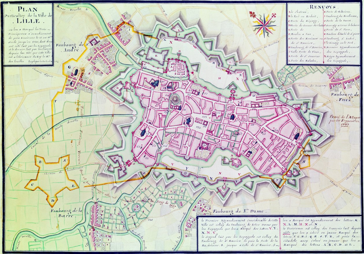
Map of the town of Lille, from “Atlas et Histoire de Lille” by Claude Masse

Map of the town of Lille, from “Atlas et Histoire de Lille”

(Map of the town of Lille, from 'Atlas et Histoire de Lille' (pen und ink und wc on paper))


Claude Masse

€ 130.42
Tax-free
   Configure art print
Undated  ·  pen and ink and watercolour on paper  ·  Image ID: 140715

Nonclassified artists  ·  Cartography

Map of the town of Lille, from “Atlas et Histoire de Lille” by Claude Masse. Available as an art print on canvas, photo paper, watercolor board, natural paper, or Japanese paper.
french · city · cartography · mapping · walls · fortifications · fortified · streets · roads · church · churches · birds eye view · aerial · Bibliotheque du Genie, Paris, France / Bridgeman Images
AR/3D   View in 3D / AR zu Favoriten hinzufügen   Add to favorites    Change wall color    View picture in a room
0 Reviews

Configure art print

Picture Frame

Medium & Stretcher

Glass & Passepartout

Miscellaneous & Extras

 Save / compare configuration
Preview Icon

Summary

Gemälde
Veredelung
Keilrahmen
Museumslizenz

€ 130.42
(inkl. 20% MwSt)
   Add to cart

Bildschärfe: PERFEKT

If you'd like us to adjust the brightness, colors, or crop the image, we're happy to do this for you at no extra cost. Just get in touch!

Similar artworks selected for you

Map of Dusseldorf, 1797 Plan of Toulon Map of the Siege of Menen, 1706 Plan of Rochefort and its surroundings, from the Map of Düsseldorf, 1736 Interactive Viewer Plan and survey of the castle, park and village of Fontainebleau Maps of Galway, Dublin, Limerick, and Cork, from Plan of Delhi, 1883 Hollar Sanitary Map of the Town of Leeds, by Stephen Sly for Her Majesty Map of Lucca from Civitates Orbis Terrarum Map of Sas de Gant and Surrounding Areas Plan of Leiden, Netherlands Leyden, Holland Map of Viterbo Ghent Map of Vicenza from Civitates Orbis Terrarum by Georg Braun Hollar Lucca, Italy An Engraved Plan of Vienna, 1770 Zutphen, Netherlands - in Zutphen, Netherlands (engraving) Plan of Lucca in 1585. Atlas by Braun & Hogenberg Siege of Menen, 1706 Plan of Lisle Map of WRATISLAVA Bresslaw, from Map of the area of Bourges Loggan
Show more similar artworks

More art prints by Claude Masse

Fol. 99 Map of Saint-Savinien on the Charente River in 1713, from Atlas 131 fol. 13, Map of Saintes, capital of Saintonge, from Map of the town of Lille, from “Atlas et Histoire de Lille” Plan of Noirmoutier-en-l Map of Bas Poitou, Pays d Plan of the Chapus Fort, from Map of part of Bas-Poitou and the Ile de Noirmoutier, 1703 Map of the towns and chateaux situated along the Charente River in 1714, from Recueil des Plans de Saintonge Cross-section and profile drawing of the Tour de Ganne at Tonnay Boutonne, from Recueil des Plans de Saintonge Cross-section and elevations of the Chapus Fort, from Traite de Fortifications Plan of Saarlouis, from Traite de Fortifications Map of Saintonge, from Recueil des Plans de Saintonge Fort of Saint-Sauveur, Lille, in 1728, from Construction of a Town Square and the Tools Used Map of Bas Poitou, Pays d
Show more works by Claude Masse

More motifs from the category Cartography

Map of Nouvelle-France (Canada) 1699 A New and Correct Map of the World, 1770-97 Map of Antwerp, from Map of Messina, from Panoramic View of the Baltic Sea and the Route of the Fleet from Spithead to St. Petersburg, from Government Maps and Charts Made Under the Supervision of an Officer in the Expedition Under Sir Charle Map of Map of the Holy Land in Old Testament times by Mons l Detail of the Ile de la Cité, from the Map of Paris c. 1540, known as the Plan de la Tapisserie, made as a Tapestry c. 1570 Map of Atlantis, from Map of the Austrian Empire, c. 1750 Map of Europe and Africa, from the ‘Sala del Mappamondo’ (Hall of the World Maps) Map of the Sea of Maluku, from the Cosmographie Universelle Map of France, Spain and North-West Africa, from the Map of the Moluccas, 1522 Mexico, in
View More from "Cartography"

A selection of our top sellers

Illustration to Dante Alighieri Roaring Stag in the Mountains The Quarrel of Oberon and Titania The Terrace at the Restaurant Jacob in Nienstedten on the Elbe Hylas and the Nymphs The Water Lily Pond, Green Reflections Philosophy Empress Eugénie (1826-1920) Surrounded by her Ladies-in-Waiting, 1855 Composition C; Composition No. III; Composition with Red, Yellow The Creation of the World, depicting the cosmic sphere of the earth (Bubble). Reverse of the wings of the triptych "The Garden of Earthly Delights". Painting by Hieronymus Van Aeken (Aken), known as Hieronymus Bosch (1450-1516) Poster for the 1936 Olympic Games, Berlin, 1936 St. Thomas Aquinas Poster advertising A Corner of the Garden at Montgeron, 1876-7 Composition VII
Show more artworks


What our customers think about us


Frequently Asked Questions about Meisterdrucke


Personalizing your art print at Meisterdrucke is simple and intuitive: Choose a frame, set the image size, pick a printing medium, and add suitable glazing or a stretcher frame. We also offer additional customization options like mats, fillets, and spacers. If you have any questions, our customer service team is ready to help you create your perfect artwork.

At Meisterdrucke, you can visualize your configured artwork directly in your own room. Simply upload a photo of your space and see how the artwork looks in it. If you're visiting us on a mobile device — phone or tablet — our augmented reality feature brings the picture to life and projects it right into your room. A unique experience that combines art and technology.

Choosing the right medium is often a matter of personal taste. To give you a better idea, we've provided some images for each medium. We also offer a sample set of all paper variants, so you can decide not just visually but by touch as well. You can order the sample set free of charge — only shipping costs apply.

Don't worry! At Meisterdrucke, we don't just process orders mechanically. Every order is manually reviewed by our team. If we spot any inconsistencies or issues with your configuration, we'll get in touch with you right away. And of course, our friendly and patient support team is always here to help you with your configuration. We'll work with you by phone or email to adjust your image so the final result is exactly what you had in mind.


Still have questions?

Are you interested in an art print from our manufactory but still unsure? Do you need advice on choosing the medium or help with the order?

Our experts are happy to assist you.

+43 4257 29415
support@meisterdrucke.com
Mo-Do: 7:00 - 16:00 | Fr: 7:00 - 13:00

Still have questions?

Are you interested in an art print from our manufactory but still unsure? Do you need advice on choosing the medium or help with the order?

Our experts are happy to assist you.

+43 4257 29415
support@meisterdrucke.com
Mo-Do: 7:00 - 16:00 | Fr: 7:00 - 13:00


Meisterdrucke

   Kärntner Strasse 46
        9586 Finkenstein am Faaker See
        Austria
        +43 4257 29415
        support@meisterdrucke.com
Other languages

                   
Erfahrungen & Bewertungen zu Meisterdrucke
Post.at DHL Express Quehenberger Cargoboard
Kaiser Franz Joseph

Meisterdrucke
Kärntner Strasse 46
9586 Finkenstein am Faaker See · Austria
+43 4257 29415 · support@meisterdrucke.com
Post.at DHL Express Quehenberger Cargoboard


(c) 2026 meisterdrucke.us