Search by artist, work title or style – e.g. Monet, Starry Night, Impressionism, Hokusai wave, nude. Describe the scene – e.g. green meadow, abstract with lots of red, dark oil painting, standing nude next to a tree.

Map of Bas Poitou, Pays d

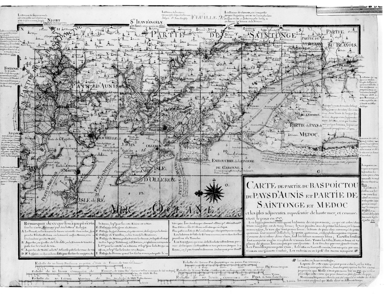
Map of Bas Poitou, Pays d'Aunis, Saintonge and Medoc, from 'Recueil des Plans de Saintonge'

(Atlas 131 F fol.2 Map of Bas Poitou, Pays d'Aunis, Saintonge and Medoc, from 'Recueil des Plans de Saintonge' (pen und ink and wc on paper) )


Claude Masse

€ 120
Enthält 0% MwSt.
   Configure art print
Undated  ·  pen & ink and watercolour on paper  ·  Picture ID: 111556

Nonclassified artists  ·  Cartography

Map of Bas Poitou, Pays d'Aunis, Saintonge and Medoc, from 'Recueil des Plans de Saintonge' by Claude Masse. Available as an art print on canvas, photo paper, watercolor board, uncoated paper or Japanese paper.
poitou-charantes · isle of re · ile d' · oleron · west coast of france · atlantic ocean · ile d' · estuary · geography · Aunis · Min. Defense - Service Historique de l'Armee de Terre,France / Bridgeman Images
AR/3D   View in 3D / AR zu Favoriten hinzufügen   Add to favorites    Select wall color    View painting in a room
0 Reviews

Configure art print

Picture Frame

Medium & Stretcher

Glass & Passepartout

Miscellaneous & Extras

 Save / compare configuration
Preview Icon

Summary

Gemälde
Veredelung
Keilrahmen
Museumslizenz

€ 120
(inkl. 20% MwSt)
   Add to cart

Bildschärfe: PERFEKT

Should you desire adjustments to brightness and color, or a custom crop of the motif, we are happy to make these changes at no additional cost to you. Please do not hesitate to contact us.

Similar artworks selected for you

A Chart of the Gulf Stream, in Map of Bas Poitou, Pays d Map of Palestine, from a Passover Haggadah, printed in 1695 Chart of Sierra Leone, Africa Map of North America, plotting the expeditions of Sir Alexander Mackenzie in 1789 and 1798 to the Arctic Ocean Map of Bas Poitou, Aunis and Saintonge with the Marshes of the Bay of Aiguillon in 1716 A Map of Western Tartary Drawn from the Survey of the Jesuits and Mr. Kyrillow Map of the Coast of Africa, 1753 Map of the route taken by Vitus Bering across Siberia to Kamchatka, from Navigantium atque Itinerantium Bibliotheca published 1744 A Map of the Province of New York with Part of Pennsylvania, and New England, from an Actual Survey by Captain Montrésor, Engineer, 1775 A New and Accurate Plan of the City and Harbour of Cartagena, Showing the Descent of That Place by the British Fleet and Land Forces, Under the Command of the Admirals Vernon and Ogle and General Wentworth in March & April 1741 Nova Scotia, c.1760 Map of Central America (Panama) from a Spanish Volume of Trips Map of Korea, Japan and East China Plan of the Bay and City of Rio de Janeiro and the disposition of the French and Portuguese naval forces during the French attack under Duguay-Trouin in 1711, c.1730 Map of the possessions of the republic of Genoa, including Corsica and Sardinia Map of the West Indies, Florida and South America Wolfe Icon Sinus Baiarum New Map for the voyage to the North West coast of Africa, Anno, drawn and printed by Dean & Munday Map of Part of the Western Coast of Celebes Map of the Canal du Midi, with its aqueducts Colony of Georgia, America Duchy or Territory of Milan Valloton Description of Guienne Map drawn up for the Algiers expedition, 1830 Map of the Travels and the Expeditions of Alexander the Great in Asia Gulf of Valencia (Aragon), Spain
Show more similar artworks

Other art prints by Claude Masse

Map of Saint-Savinien on the Charente River in 1713, from Atlas 131 fol.13 Map of Saintes, Capital of Saintonge, from Map of the Town of Lille, from Map of Bas Poitou, Pays d Map of part of Bas-Poitou and the Ile de Noirmoutier, 1703 Plan of Noirmoutier-en-l Fort of Saint-Sauveur, Lille, in 1728, from Cross-section and Elevation of the Harbour Tower at Toulon, from Map of Bas Poitou, Pays d Plan of the Chateau de Forgette, near Saint-Savinien, from Map of Bas Poitou, Aunis and Saintonge with the Marshes of the Bay of Aiguillon in 1716 Plan of the Chapus Fort, from Different Species of Tree and Sawing Logs, from Map of Saintes, capital of Saintonge, from Receuil des Plans de Saintonge, 1716 Map of the town of Tonnay-Boutonne, from Recueil des Plans de Saintonge
Discover more works by Claude Masse

Other motives from the category Cartography

Map of the World Tombleson Map of India and the East Indies Map of Europe after the Peace of Luneville, 1801, from Map of Africa Map of Palmanova, from Les Villes de Venetie, 1704, published by Rutgert Alberts in the Hague Map and Prospect of London, c.1710 Map of Australia, from The Graphic Parliamentary Map Map of Cuba and the Caribbean Map of Prussia and Poland, published by William Blackwood and Sons, Edinburgh and London, 1848 Map of Cripplegate Ward, London Map of Turkey, Middle East Horn of Africa and Persian Gulf in the 1890s, from Map of the town and citadel of Bellisle, from the Map of the County of Middlesex, published 1819
View More from "Cartography"

Excerpt from our top sellers

Tsuki Plain in Kai Province, from the series Thirty-six Views of Mount Fuji Adele Bloch-Bauer Cosmic Cliffs in the Carina Nebula Friends Baku agitation panel The Last Supper Avenue in Overveen On Board a Sailing Ship Actaeon Surprises the Goddess Artemis (Diana) Bathing with Her Companions Swimming Pool The Poor Poet Children Valencian Fishermen The Stadtbahn Pavilion of the Vienna Underground Railway, Design Showing the Exterior and a View of the Railway Platform, c.1894-97 The Bookworm
Show More Artworks


What our customers think about us


Frequently Asked Questions about Meisterdrucke


Personalizing your art print at Meisterdrucke is a simple and intuitive process that allows you to design an artwork exactly to your specifications: Choose a frame, determine the image size, decide on a printing medium, and add suitable glazing or a stretcher frame. We also offer customization options such as mats, fillets, and spacers. Our customer service is available to help you design your perfect artwork.

At Meisterdrucke, you have the fascinating option to visualize the artwork you configured directly in your own space. For a tailored preview, simply upload a photo of your room and let the artwork appear on it. If you visit us via a mobile device, be it a phone or tablet, our augmented reality feature brings the image to life and seamlessly projects it into your space. An experience that uniquely combines art and technology.

Choosing the medium is often a matter of personal taste. To give you a clearer idea, we have provided some images for each medium. For a holistic experience, we also offer you a sample set of all paper variants so you can make a decision not just visually but also haptically. You can take advantage of the sample set free of charge – only the shipping costs will apply. You can order the sample set directly.

Do not worry. At Meisterdrucke, we do not proceed mechanically. We manually review each order. If there are any inconsistencies or peculiarities in the configuration, we will immediately contact you. Of course, our courteous and patient support is always at your side to assist you with the configuration. Together with you, we adjust your image by phone or email so that the final result exactly meets your expectations.


Do you have any questions?

Are you interested in an art print from our manufactory but still unsure? Do you need advice on choosing the medium or help with the order?

Our experts are happy to assist you.

+43 4257 29415
support@meisterdrucke.com
Mo-Do: 7:00 - 16:00 | Fr: 7:00 - 13:00

Do you have any questions?

Are you interested in an art print from our manufactory but still unsure? Do you need advice on choosing the medium or help with the order?

Our experts are happy to assist you.

+43 4257 29415
support@meisterdrucke.com
Mo-Do: 7:00 - 16:00 | Fr: 7:00 - 13:00


Meisterdrucke

   Kärntner Strasse 46
        9586 Finkenstein am Faaker See
        Austria
        +43 4257 29415
        support@meisterdrucke.com
Other languages

                   
Erfahrungen & Bewertungen zu Meisterdrucke
Post.at DHL Express Quehenberger Cargoboard
Kaiser Franz Joseph

Meisterdrucke
Kärntner Strasse 46
9586 Finkenstein am Faaker See · Austria
+43 4257 29415 · office@meisterdrucke.com
Post.at DHL Express Quehenberger Cargoboard


Meisterdrucke 2758 Bewertungen auf ProvenExpert.com

(c) 2025 meisterdrucke.us