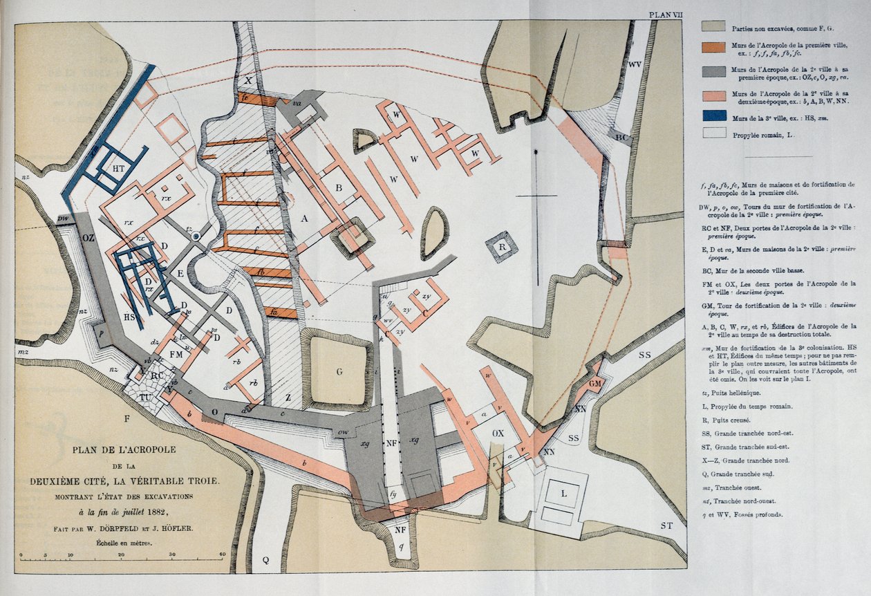
Map of the Acropolis of the 2nd city at Troy by W and Hoefler, J. Doerpfeld

Map of the Acropolis of the 2nd city at Troy

(Map of the Acropolis of the 2nd city at Troy, 1884 )


W and Hoefler, J. Doerpfeld

€ 124.8
Enthält 0% MwSt.
   Configure art print
1884  ·  colour lithograph  ·  Picture ID: 362969

Nonclassified artists  ·  Cartography

Map of the Acropolis of the 2nd city at Troy by W and Hoefler, J. Doerpfeld. Available as an art print on canvas, photo paper, watercolor board, uncoated paper or Japanese paper.
the true city · homer · iliad · odyssey · legend · archaeology · ancient greece · greek · Private Collection / Bridgeman Images
zu Favoriten hinzufügen   Add to favorites    Select wall color    View painting in a room AR/3D   View in 3D / AR
0 Reviews

Configure art print

Picture Frame

Medium & Stretcher

Glass & Passepartout

Miscellaneous & Extras

 Save / compare configuration
Preview Icon

Summary

Gemälde
Veredelung
Keilrahmen
Museumslizenz

€ 124.8
(inkl. 20% MwSt)
   Add to cart

Bildschärfe: PERFEKT

Should you desire adjustments to brightness and color, or a custom crop of the motif, we are happy to make these changes at no additional cost to you. Please do not hesitate to contact us.

Similar artworks selected for you

Plan of Delhi, 1883 Plan for the Construction of the Coast Batteries for the Defence of Breton Harbour in 1848 Plan of the City of Lucknow, from Cassell Kensington in 1764 Plan of Troy: Excavation of Heinrich Schliemann Plan of the Town of Sydney, from Voyage Autour du Monde, published 1822-24 Plan of part of the port and town of Rochefort relating to the proposed stranding tracks between the old form and the food channel Modern Jerusalem Guild Hall City of London Plan Plan of Lucca in 1585. Atlas by Braun & Hogenberg Fleet Street, The Temple, etc., from a Map of London, Published 1720, 1897 Plan of Arundel and Essex Houses, 1881 New York Plan and cut of the Citadel of Sisteron Map of the ancient city of Greece Tiryns, Heinrich Schliemann, Paris Plan of the City of Vevey in 1726 Map of the Roman Forum Plan of the Castle Correct Survey of Dublin, As It Stood in the Year 1610 Plan of the Battle of Bithoor, 16th August 1857, from Cassell Ground plan of the Vatican, Rome, engraved by Alessandro Specchi Plan of Toulon Plan of Cawnpore 1857, from Cassell Sanitary Map of the Town of Leeds, by Stephen Sly for Her Majesty Chichester Cathedral, 20th Century Map of Dusseldorf, 1797 Large plan of the entrance of the town of Pompeii, and its surrounding buildings, 1804 Roman London, 1908 Jerusalem in the Byzantine Period, Jerusalem, Israel
Show more similar artworks

Other motives from the category Cartography

Map of the Russian empire in the sixteenth century, copy of an original of 1571 Map of the Taking of Tunis by the Spanish in 1573 West Coast of Africa, from Lisbon to Sierra Leone, from Map of the route followed by Hernando Cortes during the conquest of Mexico World Map detailing the Expeditions and Global Circumnavigation of Sir Francis Drake (c.1540-96) 1577-2580 Map of the world, based on descriptions and co-ordinates given in Map of Europe after the Peace of Tilsit in 1807, from Map of Essex, 1602-03 Compass point, Renaissance map of Europe, Jacopo Russo (after) 1528 Map of Charles V, Map of Mecia de Viladestes, a portulan of Europe and North Africa, 1413 A Map of the North Pole Map of Spain and Portugal, from Map of Africa, Published in 1700, Paris Map of Nouvelle-France (Canada) 1699 Map of Mexico or New Spain, 1625
View More from "Cartography"

Excerpt from our top sellers

Iseh in morning light The Course of Empire: The Arcadian or Pastoral State Vase of Flowers The Chocolate Girl (La Belle Chocolatière de Vienne) The Attic Room Time for a Bathe, Valencia Olive Trees with Yellow Sky and Sun Turkish Café Buddha The Destruction of Herculaneum and Pompeii Valencian Fishermen Wandering Shadows The Annunciation, 1474-75 The Sun View of El Castillo, 1844
Show More Artworks


What our customers think about us


Frequently Asked Questions about Meisterdrucke


Personalizing your art print at Meisterdrucke is a simple and intuitive process that allows you to design an artwork exactly to your specifications: Choose a frame, determine the image size, decide on a printing medium, and add suitable glazing or a stretcher frame. We also offer customization options such as mats, fillets, and spacers. Our customer service is available to help you design your perfect artwork.

At Meisterdrucke, you have the fascinating option to visualize the artwork you configured directly in your own space. For a tailored preview, simply upload a photo of your room and let the artwork appear on it. If you visit us via a mobile device, be it a phone or tablet, our augmented reality feature brings the image to life and seamlessly projects it into your space. An experience that uniquely combines art and technology.

Choosing the medium is often a matter of personal taste. To give you a clearer idea, we have provided some images for each medium. For a holistic experience, we also offer you a sample set of all paper variants so you can make a decision not just visually but also haptically. You can take advantage of the sample set free of charge – only the shipping costs will apply. You can order the sample set directly.

Do not worry. At Meisterdrucke, we do not proceed mechanically. We manually review each order. If there are any inconsistencies or peculiarities in the configuration, we will immediately contact you. Of course, our courteous and patient support is always at your side to assist you with the configuration. Together with you, we adjust your image by phone or email so that the final result exactly meets your expectations.


Do you have any questions?

Are you interested in an art print from our manufactory but still unsure? Do you need advice on choosing the medium or help with the order?

Our experts are happy to assist you.

+43 4257 29415
support@meisterdrucke.com
Mo-Do: 7:00 - 16:00 | Fr: 7:00 - 13:00

Do you have any questions?

Are you interested in an art print from our manufactory but still unsure? Do you need advice on choosing the medium or help with the order?

Our experts are happy to assist you.

+43 4257 29415
support@meisterdrucke.com
Mo-Do: 7:00 - 16:00 | Fr: 7:00 - 13:00


Meisterdrucke

   Kärntner Strasse 46
        9586 Finkenstein am Faaker See
        Austria
        +43 4257 29415
        support@meisterdrucke.com
Other languages

                   
Erfahrungen & Bewertungen zu Meisterdrucke
Partner Logos

Kaiser Franz Joseph

Meisterdrucke
Kärntner Strasse 46
9586 Finkenstein am Faaker See · Austria
+43 4257 29415 · office@meisterdrucke.com
Partner Logos


(c) 2025 meisterdrucke.us