support@meisterdrucke.com  ·  0043 4257 29415

Deutsch English Italiano Español Français Nederlands Português Svenska Polski Dansk
Search by artist, work title or style – e.g. Monet, Starry Night, Impressionism, Hokusai wave, nude. Describe the scene – e.g. green meadow, abstract with lots of red, dark oil painting, standing nude next to a tree.

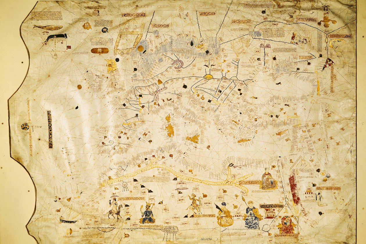
Map of Charles V, map by Mecia de Viladestes, a portolan of Europe and North Africa, 1413 by Spanish School

Map of Charles V, map by Mecia de Viladestes, a portolan of Europe and North Africa, 1413

(Map of Charles V, Map of Mecia de Viladestes, a portulan of Europe and North Africa, 1413 (vellum))


Spanish School

€ 134.09
Tax-free
   Configure art print
1413  ·  vellum  ·  Image ID: 36081

Cultural Circles  ·  Cartography

Map of Charles V, map by Mecia de Viladestes, a portolan of Europe and North Africa, 1413 by Spanish School. Available as an art print on canvas, photo paper, watercolor board, natural paper, or Japanese paper.
villadestes · sahara · niger river · african · europe · portulan · Bibliotheque Nationale, Paris, France / Bridgeman Images
AR/3D   View in 3D / AR zu Favoriten hinzufügen   Add to favorites    Change wall color    View picture in a room
0 Reviews

Configure art print

Picture Frame

Medium & Stretcher

Glass & Passepartout

Miscellaneous & Extras

 Save / compare configuration
Preview Icon

Summary

Gemälde
Veredelung
Keilrahmen
Museumslizenz

€ 134.09
(inkl. 20% MwSt)
   Add to cart

Bildschärfe: PERFEKT

If you'd like us to adjust the brightness, colors, or crop the image, we're happy to do this for you at no extra cost. Just get in touch!

Similar artworks selected for you

World Chart, from Eastern Coasts of America to India Chart by Juan de la Cosa (1500) Unknown Image Nautical chart of the Mediterranean Sea and the Black Sea Coasts of Europe and North Africa Geographic map of the Mediterranean Guillmus Soleri civis maioricaru me fecit Marine chart of the Mediterranean Sea and the Black Sea Marco Polo Nautical chart of the Mediterranean area, including Europe with British Isles and part of Scandinavia Map of the Moluccas, 1522 Cotton Roll XIII, 44 Italie provincie modernus situs Map of China (Cathay), with descriptions of small scenes, delimitation of the kingdoms with its sovereign represented each time View of China (Cambaluc, now Beijing), detail of the world map (mappamundi) by Brother Maurus (Mauro) Camaldolese, 1459 Cathay, China, from the Catalan Atlas Portolan Chart of Gabriel de Vallseca Nautical chart of the Mediterranean Sea and the Black Sea, 1440s Catalan Atlas Europe, from a 19th-century copy of the nautical planisphere by Juan de la Cosa Plan of Rome 7249 Esp.30 f.2v-3 Detail from a Catalan World Map, 1375 A Nautical Map, detail of Western Europe, 1564 Mappa Mundi, 1502 World Chart, from Eastern Coasts of America to India Genoese world map, designed by Toscanelli Detail of the Mediterranean from the Mappa Mundi, c.1290 Spanish portolan chart View of the Archipelago of Borneo (detail) Catalan Atlas, 1375
Show more similar artworks

Similar artworks selected for you

World Chart, from Eastern Coasts of America to India Chart by Juan de la Cosa (1500) Unknown Image Nautical chart of the Mediterranean Sea and the Black Sea Coasts of Europe and North Africa Geographic map of the Mediterranean Guillmus Soleri civis maioricaru me fecit Marine chart of the Mediterranean Sea and the Black Sea Marco Polo Nautical chart of the Mediterranean area, including Europe with British Isles and part of Scandinavia Map of the Moluccas, 1522 Cotton Roll XIII, 44 Italie provincie modernus situs Map of China (Cathay), with descriptions of small scenes, delimitation of the kingdoms with its sovereign represented each time View of China (Cambaluc, now Beijing), detail of the world map (mappamundi) by Brother Maurus (Mauro) Camaldolese, 1459 Cathay, China, from the Catalan Atlas Portolan Chart of Gabriel de Vallseca Nautical chart of the Mediterranean Sea and the Black Sea, 1440s Catalan Atlas Europe, from a 19th-century copy of the nautical planisphere by Juan de la Cosa Plan of Rome 7249 Esp.30 f.2v-3 Detail from a Catalan World Map, 1375 A Nautical Map, detail of Western Europe, 1564 Mappa Mundi, 1502 World Chart, from Eastern Coasts of America to India Genoese world map, designed by Toscanelli Detail of the Mediterranean from the Mappa Mundi, c.1290 Spanish portolan chart View of the Archipelago of Borneo (detail) Catalan Atlas, 1375
Show more similar artworks

More art prints by Spanish School

Christ of Burgos, in the Chapel of the Most Holy Christ The hand of God, detail of a fresco by the Master of Sant Climent de Taüll Map of Tenochtitlan and the Gulf of Mexico, from Praeclara Ferdinadi Cortesii de Nova maris Oceani Hyspania Narratio by Hernando Cortés (1485-1547), 1524 One of two pink Qur Fol. 61v Game of pelota in the open air, from the manuscript made under the direction of Alfonso X (1221-84) the Wise, King of Castile and León Angels and David with the Ark of the Covenant standing before the Temple of Solomon, fol. 139r., from the Visigothic-Mozarabic Bible of St. Isidore, A.D. 960 Genealogy of the Inca rulers and their Spanish successors from Manco Capac, the first Inca king, to Ferdinand VI of Spain, c. 1750 Map showing the route of Christopher Columbus on his first voyage to the New World Teresa of Ávila Complutensian Polyglot Bible, printed by Arnao Guillen de Brocar Map of the Island of Mallorca, 1785 View of the Lower Gallery of the Monastery of San Juan de Los Reyes, Toledo Interior view of the ’Great Lyceum’ during a carnival before the fire which destroyed the theatre Charles V (1500-58) Map of Charles V, map by Mecia de Viladestes, a portolan of Europe and North Africa, 1413
Show more works by Spanish School

More art prints by Spanish School

Christ of Burgos, in the Chapel of the Most Holy Christ The hand of God, detail of a fresco by the Master of Sant Climent de Taüll Map of Tenochtitlan and the Gulf of Mexico, from Praeclara Ferdinadi Cortesii de Nova maris Oceani Hyspania Narratio by Hernando Cortés (1485-1547), 1524 One of two pink Qur Fol. 61v Game of pelota in the open air, from the manuscript made under the direction of Alfonso X (1221-84) the Wise, King of Castile and León Angels and David with the Ark of the Covenant standing before the Temple of Solomon, fol. 139r., from the Visigothic-Mozarabic Bible of St. Isidore, A.D. 960 Genealogy of the Inca rulers and their Spanish successors from Manco Capac, the first Inca king, to Ferdinand VI of Spain, c. 1750 Map showing the route of Christopher Columbus on his first voyage to the New World Teresa of Ávila Complutensian Polyglot Bible, printed by Arnao Guillen de Brocar Map of the Island of Mallorca, 1785 View of the Lower Gallery of the Monastery of San Juan de Los Reyes, Toledo Interior view of the ’Great Lyceum’ during a carnival before the fire which destroyed the theatre Charles V (1500-58) Map of Charles V, map by Mecia de Viladestes, a portolan of Europe and North Africa, 1413
Show more works by Spanish School

More motifs from the category Cartography

Map of the Battle of Wagram, published by William Blackwood and Sons, Edinburgh and London, 1848 Map of London, from “Civitates Orbis Terrarum” by Georg Braun (1542-1622) and Frans Hogenburg (1635-90), c. 1572 Map of Florida, c. 1584 An inciting map of the Turbid Amazon, illustration from Map of Britain in 626, from The Northumbrian Kingdom 588 to 685 in General map including Arabia, Japan, the Korean peninsula and the greater part of the Indonesian archipelago, 1631 New and most accurate map of all New Netherland, 1674 A New Map of the Roman Empire, from "A Prospect of the Most Famous Parts of the World", published by Bassett and Chiswell, 1676 Map of Africa, published in 1700, Paris French school textbook map of Indochina, 1905 Feudal France at the time of the accession of Hugues Capet in 987, map illustrated in a Histoire de France, c. 1880 Map of the Battle of Bautzen, published by William Blackwood and Sons, Edinburgh and London, 1848 The Pacific Ocean, from an Atlas of the World in 33 Maps, Venice, 1st September 1553 Zodiac Calendar, from an Atlas of the World in 33 Maps, Venice, 1st September 1553 Map of Lisbon, from
View More from "Cartography"

More motifs from the category Cartography

Map of the Battle of Wagram, published by William Blackwood and Sons, Edinburgh and London, 1848 Map of London, from “Civitates Orbis Terrarum” by Georg Braun (1542-1622) and Frans Hogenburg (1635-90), c. 1572 Map of Florida, c. 1584 An inciting map of the Turbid Amazon, illustration from Map of Britain in 626, from The Northumbrian Kingdom 588 to 685 in General map including Arabia, Japan, the Korean peninsula and the greater part of the Indonesian archipelago, 1631 New and most accurate map of all New Netherland, 1674 A New Map of the Roman Empire, from "A Prospect of the Most Famous Parts of the World", published by Bassett and Chiswell, 1676 Map of Africa, published in 1700, Paris French school textbook map of Indochina, 1905 Feudal France at the time of the accession of Hugues Capet in 987, map illustrated in a Histoire de France, c. 1880 Map of the Battle of Bautzen, published by William Blackwood and Sons, Edinburgh and London, 1848 The Pacific Ocean, from an Atlas of the World in 33 Maps, Venice, 1st September 1553 Zodiac Calendar, from an Atlas of the World in 33 Maps, Venice, 1st September 1553 Map of Lisbon, from
View More from "Cartography"

A selection of our top sellers

Paris Street; Rainy Day The Youth of Bacchus, 1884. The Destruction of an Empire Farm Garden Panorama of Views of Kanazawa Under Full Moon, from the series A Street at Night The Artist The Gleaners The Sunday Walk Self-Portrait with Physalis Judith with the Head of Holofernes Pallas Athena (in Armour) Olive Trees with Yellow Sky and Sun The Piri Reis World Map, 1513 Woman with a Veil, 1915
Show more artworks

A selection of our top sellers

Paris Street; Rainy Day The Youth of Bacchus, 1884. The Destruction of an Empire Farm Garden Panorama of Views of Kanazawa Under Full Moon, from the series A Street at Night The Artist The Gleaners The Sunday Walk Self-Portrait with Physalis Judith with the Head of Holofernes Pallas Athena (in Armour) Olive Trees with Yellow Sky and Sun The Piri Reis World Map, 1513 Woman with a Veil, 1915
Show more artworks


What our customers think about us


Frequently Asked Questions about Meisterdrucke


Personalizing your art print at Meisterdrucke is simple and intuitive: Choose a frame, set the image size, pick a printing medium, and add suitable glazing or a stretcher frame. We also offer additional customization options like mats, fillets, and spacers. If you have any questions, our customer service team is ready to help you create your perfect artwork.

At Meisterdrucke, you can visualize your configured artwork directly in your own room. Simply upload a photo of your space and see how the artwork looks in it. If you're visiting us on a mobile device — phone or tablet — our augmented reality feature brings the picture to life and projects it right into your room. A unique experience that combines art and technology.

Choosing the right medium is often a matter of personal taste. To give you a better idea, we've provided some images for each medium. We also offer a sample set of all paper variants, so you can decide not just visually but by touch as well. You can order the sample set free of charge — only shipping costs apply.

Don't worry! At Meisterdrucke, we don't just process orders mechanically. Every order is manually reviewed by our team. If we spot any inconsistencies or issues with your configuration, we'll get in touch with you right away. And of course, our friendly and patient support team is always here to help you with your configuration. We'll work with you by phone or email to adjust your image so the final result is exactly what you had in mind.


Still have questions?

Are you interested in an art print from our manufactory but still unsure? Do you need advice on choosing the medium or help with the order?

Our experts are happy to assist you.

+43 4257 29415
support@meisterdrucke.com
Mo-Do: 7:00 - 16:00 | Fr: 7:00 - 13:00

Still have questions?

Are you interested in an art print from our manufactory but still unsure? Do you need advice on choosing the medium or help with the order?

Our experts are happy to assist you.

+43 4257 29415
support@meisterdrucke.com
Mo-Do: 7:00 - 16:00 | Fr: 7:00 - 13:00


Meisterdrucke

   Kärntner Strasse 46
        9586 Finkenstein am Faaker See
        Austria
        +43 4257 29415
        support@meisterdrucke.com
Other languages

                   
Erfahrungen & Bewertungen zu Meisterdrucke
Post.at DHL Express Quehenberger Cargoboard
Kaiser Franz Joseph

Meisterdrucke
Kärntner Strasse 46
9586 Finkenstein am Faaker See · Austria
+43 4257 29415 · support@meisterdrucke.com
Post.at DHL Express Quehenberger Cargoboard


(c) 2026 meisterdrucke.us