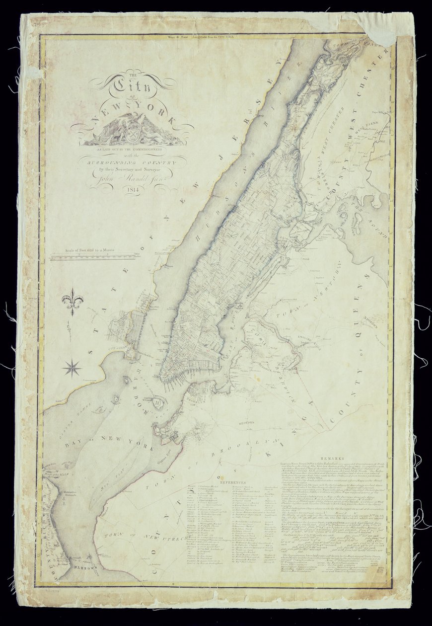
Map of the City of New York as Laid Out by the Commissioners, 1814 by John Jr. Randel

Map of the City of New York as Laid Out by the Commissioners, 1814


John Jr. Randel

€ 124.11
Enthält 0% MwSt.
   Configure art print
1814  ·  Picture ID: 240066

Nonclassified artists  ·  Cartography

Map of the City of New York as Laid Out by the Commissioners, 1814 by John Jr. Randel. Available as an art print on canvas, photo paper, watercolor board, uncoated paper or Japanese paper.
island · urban planning · east coast · grid · america · Collection of the New-York Historical Society, USA / Bridgeman Images
Other color variations of this picture  
zu Favoriten hinzufügen   Add to favorites    Select wall color    View painting in a room AR/3D   View in 3D / AR
0 Reviews

Configure art print

Picture Frame

Medium & Stretcher

Glass & Passepartout

Miscellaneous & Extras

 Save / compare configuration
Preview Icon

Summary

Gemälde
Veredelung
Keilrahmen
Museumslizenz

€ 124.11
(inkl. 20% MwSt)
   Add to cart

Bildschärfe: PERFEKT

Should you desire adjustments to brightness and color, or a custom crop of the motif, we are happy to make these changes at no additional cost to you. Please do not hesitate to contact us.

Similar artworks selected for you

Plan of the City of New York in North America Surveyed in the Years 1766 and 1767 Published in Faden Map of New York Island with the adjacent rocks and other remarkable parts of Hell-Gate A Topographical Map of the Northern Part of New York Island A Chart of the Harbour of Rhode Island and Narraganset Bay Map of Lower New York State and surrounding areas, c.1775 The City of New York as Laid Out by the Commissioners with the Surrounding Country A Topographical Chart of Rhode Island Plan of the City of New York in North America Surveyed in the Years 1766 and 1767 Published in Faden A Plan of the City of New York and Its Environs to Greenwich on the North (Hudson) River to Crown Point on the East River, Surveyed 1766, 1775 A Plan of New York Island British map of the Siege of Yorktown, 1781 A Map of the Province of New York by Captain Montresor A sketch of the operations before Charlestown, the capital of South Carolina, c.1780 A plan of New York Island, with part of Long Island, Staten Island and East New Jersey, with a particular description of the engagement on the woody heights of Long Island between Flatbush and Brooklyn Map Showing the High and Low Water Mark and the Original City Grants of Land Under Water Made to Various Parties from 1686 to 1873, Extending from Battery to Fifty-first Street, Judson and East Rivers Chart of Ipswich Bay and Cape Ann, Atlantic coast of North America A plan of Fort Montgomery & Fort Clinton, 1774-1779 Part of South Australia, from a Series of World Maps published by John Tallis und Co, New York and London A Chart of the Harbour of Rhode Island and Narragansett Bay Chart of Terra Australis by M Flinders, Commr of His Majesty This Map of the City of New York and Island of Manhattan as Laid Out by the Commissioners Appointed by the Legislature, 1853 New-York City, County, and vicinity A Plan of the City of New York by Ratzer Plan of New York Island with Part of Long Island, Staten Island and East New Jersey and the Engagement on the Woody Heights of Long Island between the British Forces, under the command of General Sir William Howe Plans of the city and harbour of New York, c.1740 A Map of New York Grosse Isle and Part of Lake Erie, 1796 Particular Map of a Part of Louisiana Where the Rivers and Routes Were Estimated and Measured by Steps, by Messrs. Broutin, de Vergés, Engineers & Saucier, Draughtsman
Show more similar artworks

Other motives from the category Cartography

Scott Historiated initial Map of Forata and Jeresa from Map of Map of Bergen, from Map of the Ladrones Islands, from an account of the Voyage of Ferdinand Magellan A New and Correct Map of the Trading Part of the West Indies Map of the Wards of Coleman Street and Bassishaw, London Part of the Tabula Peutingeriana, an illustrated itinerarium of the road network in the Roman Empire. Detail of Italy from the Peutinger map copy Map of Israel, from Map of the Suez Canal, c.1870 Map of London showing the Birmingham, Bristol, Thames Junction railway, 1839 Map showing the localities of the Indian tribes of the US in 1833, illustration from Italy and Sicily from a Renaissance map of Europe, Jacopo Russo (after) 1528 Map of the Battle of Novi, published by William Blackwood and Sons, Edinburgh and London, 1848
View More from "Cartography"

Excerpt from our top sellers

A Corner of the Garden at Montgeron, 1876-7 The Gare Saint-Lazare: Arrival of a Train Salvator Mundi Cosmic Cliffs in the Carina Nebula Spring, from a series depicting the four seasons, 1573 Sunlight in the Blue Room Roller Skating Club Around the Alex The Sun Bathers Boy viewing Mount Fuji, 1839 The Water-Lily Pond The Lady of Shalott Iseh in morning light The Seasons: Autumn, 1896 A Storm in the Rocky Mountains, Mt. Rosalie The Roses of Heliogabalus
Show More Artworks


What our customers think about us


Frequently Asked Questions about Meisterdrucke


Personalizing your art print at Meisterdrucke is a simple and intuitive process that allows you to design an artwork exactly to your specifications: Choose a frame, determine the image size, decide on a printing medium, and add suitable glazing or a stretcher frame. We also offer customization options such as mats, fillets, and spacers. Our customer service is available to help you design your perfect artwork.

At Meisterdrucke, you have the fascinating option to visualize the artwork you configured directly in your own space. For a tailored preview, simply upload a photo of your room and let the artwork appear on it. If you visit us via a mobile device, be it a phone or tablet, our augmented reality feature brings the image to life and seamlessly projects it into your space. An experience that uniquely combines art and technology.

Choosing the medium is often a matter of personal taste. To give you a clearer idea, we have provided some images for each medium. For a holistic experience, we also offer you a sample set of all paper variants so you can make a decision not just visually but also haptically. You can take advantage of the sample set free of charge – only the shipping costs will apply. You can order the sample set directly.

Do not worry. At Meisterdrucke, we do not proceed mechanically. We manually review each order. If there are any inconsistencies or peculiarities in the configuration, we will immediately contact you. Of course, our courteous and patient support is always at your side to assist you with the configuration. Together with you, we adjust your image by phone or email so that the final result exactly meets your expectations.


Do you have any questions?

Are you interested in an art print from our manufactory but still unsure? Do you need advice on choosing the medium or help with the order?

Our experts are happy to assist you.

+43 4257 29415
support@meisterdrucke.com
Mo-Do: 7:00 - 16:00 | Fr: 7:00 - 13:00

Do you have any questions?

Are you interested in an art print from our manufactory but still unsure? Do you need advice on choosing the medium or help with the order?

Our experts are happy to assist you.

+43 4257 29415
support@meisterdrucke.com
Mo-Do: 7:00 - 16:00 | Fr: 7:00 - 13:00


Meisterdrucke

   Kärntner Strasse 46
        9586 Finkenstein am Faaker See
        Austria
        +43 4257 29415
        support@meisterdrucke.com
Other languages

                   
Erfahrungen & Bewertungen zu Meisterdrucke
Partner Logos

Kaiser Franz Joseph

Meisterdrucke
Kärntner Strasse 46
9586 Finkenstein am Faaker See · Austria
+43 4257 29415 · office@meisterdrucke.com
Partner Logos


(c) 2025 meisterdrucke.us