support@meisterdrucke.com  ·  0043 4257 29415

Deutsch English Italiano Español Français Nederlands Português Svenska Polski Dansk
Search by artist, work title or style – e.g. Monet, Starry Night, Impressionism, Hokusai wave, nude. Describe the scene – e.g. green meadow, abstract with lots of red, dark oil painting, standing nude next to a tree.

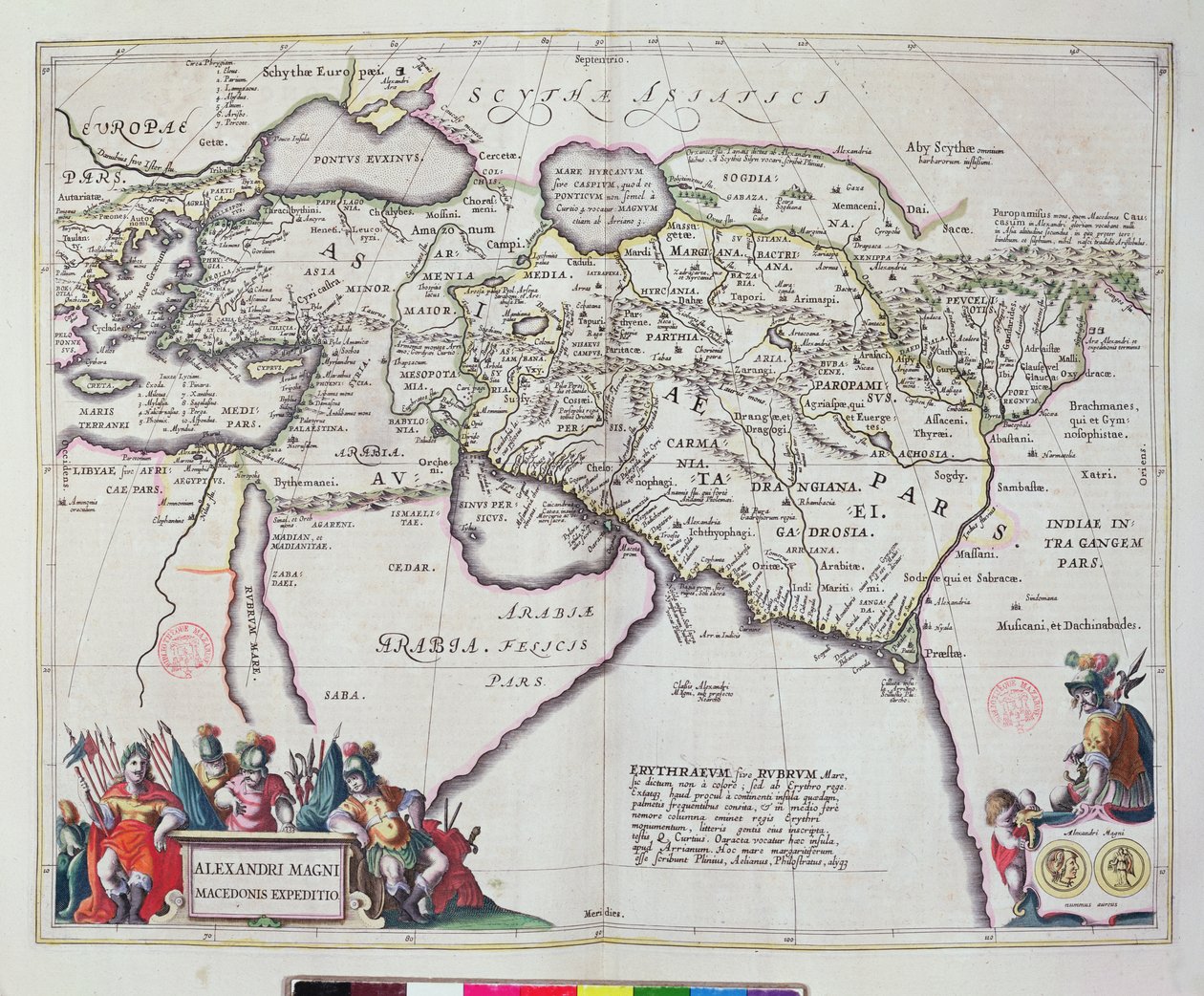
Map of the travels of Alexander the Great (356-323 BC) from

Map of the travels of Alexander the Great (356-323 BC) from 'Le Théâtre du Monde' or 'Nouvel Atlas', 1645

(Map of the travels of Alexander the Great (356-323 BC) from 'Le Theatre du Monde' or 'Nouvel Atlas', 1645 )


Joan Blaeu

€ 119.3
Tax-free
   Configure art print
1645  ·  coloured engraving  ·  Image ID: 259626

Nonclassified artists  ·  Cartography

Map of the travels of Alexander the Great (356-323 BC) from 'Le Théâtre du Monde' or 'Nouvel Atlas', 1645 by Joan Blaeu. Available as an art print on canvas, photo paper, watercolor board, natural paper, or Japanese paper.
guillaume · jean · bleau · cartography · cartographic · middle east · arabia · empire · gulf · conquest · Bibliotheque Mazarine, Paris, France / Bridgeman Images
Other color versions of this image  
AR/3D   View in 3D / AR zu Favoriten hinzufügen   Add to favorites    Change wall color    View picture in a room
0 Reviews

Configure art print

Picture Frame

Medium & Stretcher

Glass & Passepartout

Miscellaneous & Extras

 Save / compare configuration
Preview Icon

Summary

Gemälde
Veredelung
Keilrahmen
Museumslizenz

€ 119.3
(inkl. 20% MwSt)
   Add to cart

Bildschärfe: PERFEKT

If you'd like us to adjust the brightness, colors, or crop the image, we're happy to do this for you at no extra cost. Just get in touch!

Similar artworks selected for you

Janssonius Map of Persia Persian Empire, in Turkish Empire, in Map of the Turkish Empire Italy, Balkan Peninsula, Turkey, Lebanon, Syria, Israel, Jordan, Iraq, Arabian Peninsula, Iran A Map of Turkish Possessions Including Egypt and Greece Turkey - Arabia and Iran Map of Russia From: Theatrum Orbis Terrarum General Map Including Arabia, Japan, the Korean Peninsula and the Greater Part of the Indonesian Archipelago, 1631 East Europe, Asia and north Africa - by A Map of the Course of the Danube River in Germany South-east Germany, south Czech Republic, Austria, west Slovakia, west Hungary, Slovenia, Croatia, Bosnia and Herzegovina The Expedition of Alexander the Great, from the Tartary and Northern Part of China and Korea, in Turkey, Cyprus, Lebanon, Syria, Israel, Jordan, Iraq, Arabian Peninsula, Iran, Turkmenistan, Afghanistan, Pakistan The theatre of the world or the new atlas Amsterdam. Geographic map of Asia by Willem Janszoon Blaeu Map of the Mediterranean with Allegorical Figures and Sea Monsters, from Map of Africa, from Atlas Minor, published in Augsburg, first half of eighteenth century A New Map of Asia Map of Ottoman Empire Russia Map of Persia (Iran), Armenia, Anatolia (Turkey) and Arabia (Arabian Peninsula: Saudi Arabia, Kuwait, United Arab Emirates, Oman, Qatar, Yemen, Bahrain) Map of the Russian Empire in the sixteenth century, copy of an original of 1571 Friuli, Italy - Slovenia (Istria) with the Gulf of Trieste and Balkans (engraving) The Turkish Empire, from Map of Russia, around Moscow city Netherlands, Germany Map of the Roman Empire, Theatrum Orbis Terrarum, Abraham Ortelius, Antwerp
Show more similar artworks

More art prints by Joan Blaeu

Luxembourg, the capital of the Duchy Map of East Prussia Italy, Map of Pesaro, from Theatrum civitatum et admirandorum Italiae by Joan Blaeu, engraving Map of Spoleto Map of Virginia and Florida Map of the travels of Alexander the Great (356-323 BC) from Map of the gold-bearing regions in Peru, from the Atlas Maior, Sive Cosmographia Blaviana, 1662 General View of the Observatory of Uraniborg, constructed c.1584 by Tycho Brahe (1546-1601) on the island of Hven, Denmark, from Map of Europe from: Atlas Maior Wind rose with the 32 winds of the world, from the New and “Most Accurate” World Map Map of New Belgium and New England Map of Turin by Joan Blaeu, from Theatrum Sabaudiae Map of Racconigi, Engraving by Joan Blaeu, Italy Map showing the Kremlin, Moscow, 1662
Show more works by Joan Blaeu

More motifs from the category Cartography

A Map of Wapping, London, 1746 Map of New Belgium with a View of New Amsterdam, compiled by Nicolaes Visscher c.1651-55 Map of Silesia, from an Atlas Map of India and the East Indies The Dedication to Queen Elizabeth I from a Book of Maps of England and Wales by Christopher Saxton, Published 1579 Map of Canaan, or Palestine, published by A. K. Johnstone Map of the Manor of Shifnal, Shropshire Map of the World using the Mercator Projection, from Map of Cambridge, from Map of the World, Based on Descriptions and Coordinates Given in “Geographia”, by Ptolemy (Claudius Ptolemaeus of Alexandria) (c. 90-168 AD) Copy of an 8th-century Beatus mappa mundi Map of South Kensington Map of Rome, from the “Speculum Romanae Magnificentiae” published in 1562 Map of the British Isles, from “Geographia” Map of Calicut, from
View More from "Cartography"

A selection of our top sellers

Starry Night over the Rhône, 1888 Italian Landscape with Umbrella Pines, 1807 The Man with the Golden Helmet, c. 1650 Shinshū, Lake Suwa The Garden of the Artist in Wannsee, 1918 The Letter Carrier in Rosenthal “Remember”, “His Country” series, 1924 Shooting Stars (Franz and Mary von Stuck) Starry Night Over the Rhône Narcissus Renard the Fox, c. 1800, 1922 Woman in White Stockings, c. 1861 Still Life with Coffee Sadko Swans in the Reeds, c. 1820
Show more artworks


What our customers think about us


Frequently Asked Questions about Meisterdrucke


Personalizing your art print at Meisterdrucke is simple and intuitive: Choose a frame, set the image size, pick a printing medium, and add suitable glazing or a stretcher frame. We also offer additional customization options like mats, fillets, and spacers. If you have any questions, our customer service team is ready to help you create your perfect artwork.

At Meisterdrucke, you can visualize your configured artwork directly in your own room. Simply upload a photo of your space and see how the artwork looks in it. If you're visiting us on a mobile device — phone or tablet — our augmented reality feature brings the picture to life and projects it right into your room. A unique experience that combines art and technology.

Choosing the right medium is often a matter of personal taste. To give you a better idea, we've provided some images for each medium. We also offer a sample set of all paper variants, so you can decide not just visually but by touch as well. You can order the sample set free of charge — only shipping costs apply.

Don't worry! At Meisterdrucke, we don't just process orders mechanically. Every order is manually reviewed by our team. If we spot any inconsistencies or issues with your configuration, we'll get in touch with you right away. And of course, our friendly and patient support team is always here to help you with your configuration. We'll work with you by phone or email to adjust your image so the final result is exactly what you had in mind.


Still have questions?

Are you interested in an art print from our manufactory but still unsure? Do you need advice on choosing the medium or help with the order?

Our experts are happy to assist you.

+43 4257 29415
support@meisterdrucke.com
Mo-Do: 7:00 - 16:00 | Fr: 7:00 - 13:00

Still have questions?

Are you interested in an art print from our manufactory but still unsure? Do you need advice on choosing the medium or help with the order?

Our experts are happy to assist you.

+43 4257 29415
support@meisterdrucke.com
Mo-Do: 7:00 - 16:00 | Fr: 7:00 - 13:00


Meisterdrucke

   Kärntner Strasse 46
        9586 Finkenstein am Faaker See
        Austria
        +43 4257 29415
        support@meisterdrucke.com
Other languages

                   
Erfahrungen & Bewertungen zu Meisterdrucke
Post.at DHL Express Quehenberger Cargoboard
Kaiser Franz Joseph

Meisterdrucke
Kärntner Strasse 46
9586 Finkenstein am Faaker See · Austria
+43 4257 29415 · support@meisterdrucke.com
Post.at DHL Express Quehenberger Cargoboard


(c) 2026 meisterdrucke.us