support@meisterdrucke.com  ·  0043 4257 29415

Deutsch English Italiano Español Français Nederlands Português Svenska Polski Dansk
Search by artist, work title or style – e.g. Monet, Starry Night, Impressionism, Hokusai wave, nude. Describe the scene – e.g. green meadow, abstract with lots of red, dark oil painting, standing nude next to a tree.

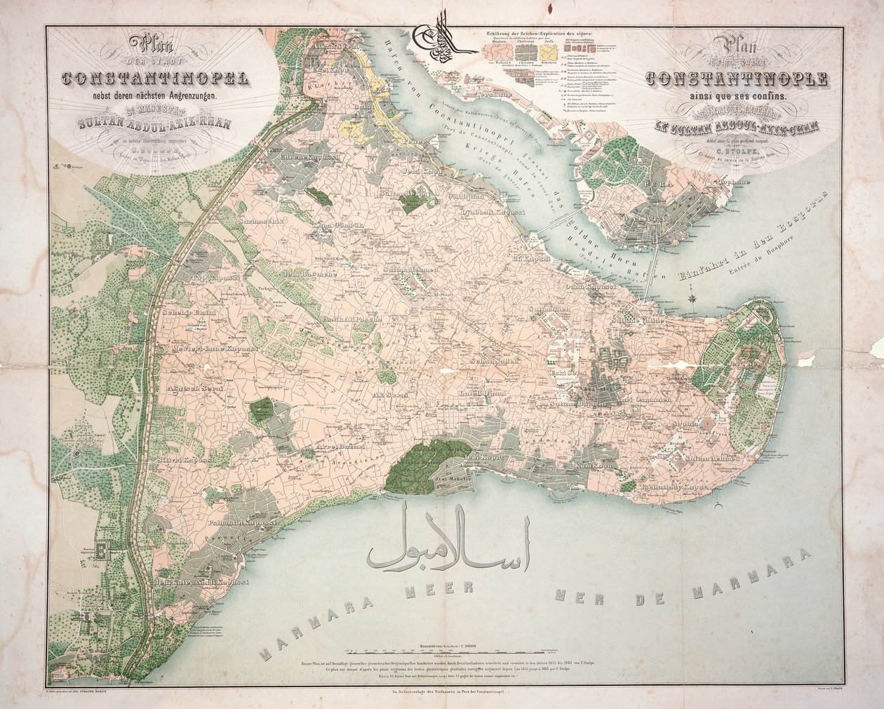
Map of Constantinople and Surrounding Areas, 1855-63 by C. Stolpe

Map of Constantinople and Surrounding Areas, 1855-63

(Map of Constantinople and surrounding areas, 1855-63 )


C. Stolpe

€ 119.08
Tax-free
   Configure art print
1855  ·  engraving  ·  Image ID: 179601

Nonclassified artists  ·  Cartography

Map of Constantinople and Surrounding Areas, 1855-63 by C. Stolpe. Available as an art print on canvas, photo paper, watercolor board, natural paper, or Japanese paper.
Private Collection / Bridgeman Images
AR/3D   View in 3D / AR zu Favoriten hinzufügen   Add to favorites    Change wall color    View picture in a room
0 Reviews

Configure art print

Picture Frame

Medium & Stretcher

Glass & Passepartout

Miscellaneous & Extras

 Save / compare configuration
Preview Icon

Summary

Gemälde
Veredelung
Keilrahmen
Museumslizenz

€ 119.08
(inkl. 20% MwSt)
   Add to cart

Bildschärfe: PERFEKT

If you'd like us to adjust the brightness, colors, or crop the image, we're happy to do this for you at no extra cost. Just get in touch!

Similar artworks selected for you

The Southern Portion of Rajpootana, 1820 Property Ownership and Land Use Map Part of a Map of Suriname, General Map of the Colony of Suriname, Mainly Showing the Current Cultivation of the Colony Map of Vladivostok Map of Kutch and Runn, India, 1854 Duchy of Guelders, Second Part, Roermond Map of the eastern territories of the Republic of Mexico as they were in 1862, from ‘The Universal Museum’, published 1862 Map of Normandy, from the 1st volume of La Normandie Illustrée, engraved by Charpentier, published in Nantes 1852 A sketch of the operations before Charlestown, the capital of South Carolina, c.1780 Map of the island of Noirmoutier accompanied by a map of the castle, made in 1769 Fecknam Manor, Worcester, 1744 Geographic map of Algeria and details of the provinces of Algiers, Oran and Constantine, made by Amboise Tardieu Map of the Island of Mallorca, 1785 The Rock of Gibraltar Map from the National Library Overland Route to India Map of Cutch and Kathiawar, published under the direction of Colonel G.C. de Pree, S.C., Surveyor General of India, 1885 Map of the Forest and Manor of Fecknam (An Administrative) Map of the 13 Provinces of the North and South Capitals Plan of Toulon Map of Southern Norway, No Title Map of Kristiania The Map is Published in (1839) and Shows Hamburg Map of Southern Russia with View of Sevastopol Bay and Its Fortifications Map of Southern Russia with View of Sevastopol Bay and Its Fortifications Map of Poperinghe A Plan of St. Philips Castle and Fortifications in the Island of Minorca Friesland, Groningen, Netherlands Chart of the River Thames and Estuary
Show more similar artworks

More motifs from the category Cartography

Map of Chinese Turkestan, from “On Ancient Central-Asian Tracks” by Stein, published 1933 The South Pole, detail from the ’Mappamonde à Projection Cordiforme’, 1531 Map of the Travels of Abraham, Isaac and Jacob, 1652 Double Hemisphere World Map, 1587 Wallis Map of Jerusalem, 1661 Map of the Battle of Laon, published by William Blackwood and Sons, Edinburgh and London, 1848 Map of Africa, 1821 Map illustrating La Rochelle occupied by the Huguenots Atlas 131 H.fol. 71, Map of part of Bas-Poitou and the Île de Noirmoutier, 1703 Map of Regensburg, from Miniature Nautical Map of the Adriatic, 1624 Map of Alexandria from “Civitates Orbis Terrarum Coloniae Agrippinae”, 1572 Map of the United States in 1803, from New and accurate map of the West Indies
View More from "Cartography"

A selection of our top sellers

Limits of Reason, 1927. Poster advertising the Baron Hotel in Aleppo, c. 1920 Starry Night over the Rhône, 1888 Landscape with Church and Path The Sun Fast Sinks in the West The White Cat Composition Z VIII Fallen Angel, 1847. Starry Night Over the Rhône The Plain of Auvers, 1890 The Great Piece of Turf, 1503 The Gare Saint-Lazare: Arrival of a Train, 1877 Thalia, the Muse of Comedy, 1897 A Vase of Roses, 1890 Wiltshire Landscape, 1937
Show more artworks


What our customers think about us


Frequently Asked Questions about Meisterdrucke


Personalizing your art print at Meisterdrucke is simple and intuitive: Choose a frame, set the image size, pick a printing medium, and add suitable glazing or a stretcher frame. We also offer additional customization options like mats, fillets, and spacers. If you have any questions, our customer service team is ready to help you create your perfect artwork.

At Meisterdrucke, you can visualize your configured artwork directly in your own room. Simply upload a photo of your space and see how the artwork looks in it. If you're visiting us on a mobile device — phone or tablet — our augmented reality feature brings the picture to life and projects it right into your room. A unique experience that combines art and technology.

Choosing the right medium is often a matter of personal taste. To give you a better idea, we've provided some images for each medium. We also offer a sample set of all paper variants, so you can decide not just visually but by touch as well. You can order the sample set free of charge — only shipping costs apply.

Don't worry! At Meisterdrucke, we don't just process orders mechanically. Every order is manually reviewed by our team. If we spot any inconsistencies or issues with your configuration, we'll get in touch with you right away. And of course, our friendly and patient support team is always here to help you with your configuration. We'll work with you by phone or email to adjust your image so the final result is exactly what you had in mind.


Still have questions?

Are you interested in an art print from our manufactory but still unsure? Do you need advice on choosing the medium or help with the order?

Our experts are happy to assist you.

+43 4257 29415
support@meisterdrucke.com

Mo-Do: 7:00 - 16:00 | Fr: 7:00 - 13:00

Still have questions?

Are you interested in an art print from our manufactory but still unsure? Do you need advice on choosing the medium or help with the order?

Our experts are happy to assist you.

+43 4257 29415
support@meisterdrucke.com
Mo-Do: 7:00 - 16:00 | Fr: 7:00 - 13:00


Meisterdrucke

   Kärntner Strasse 46
        9586 Finkenstein am Faaker See
        Austria
        +43 4257 29415
        support@meisterdrucke.com
Other languages

                   
Erfahrungen & Bewertungen zu Meisterdrucke
Post.at DHL Express Quehenberger Cargoboard
Kaiser Franz Joseph

Meisterdrucke
Kärntner Strasse 46
9586 Finkenstein am Faaker See · Austria
+43 4257 29415 · support@meisterdrucke.com
Post.at DHL Express Quehenberger Cargoboard


(c) 2026 meisterdrucke.us