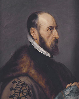
How does the world fit between two book covers? In the years before 1570, this was a practical question in Antwerp: the shipowner Gillis Hooftman bought maps for his business, but the large rolls were unwieldy in the counting house. His young confidant Jan Radermacher later recalled that he himself had suggested standardizing the maps and having them bound into a book; he had entrusted the commission to a dealer he had known for years, Abraham Ortelius.
Ortelius was actually named Abraham Ortel and had Latinized his name in the scholarly fashion; he was a Fleming from Antwerp, born in 1527. His father, a merchant with roots in Augsburg, died around 1535; responsibility for his mother and sister fell to the son at an early age. In 1547, the Guild of Saint Luke, the painters' guild, registered him as a map colorist - he colored what others had engraved, traded in books, prints, and maps, and traveled regularly to the Frankfurt Fair. There, in 1554, he met the cartographer Gerard Mercator; during a journey together in 1560, his famous colleague is said to have urged him to make maps himself.
The answer to the problem from the counting house appeared in Antwerp on May 20, 1570: the Theatrum Orbis Terrarum, the Theater of the World. Fifty-three map sheets in a single format, each plate engraved specifically for the book, with an explanatory text on the reverse of every sheet - this is why the work is regarded as the first modern atlas, although the word atlas itself did not come into circulation until Mercator's map collection of 1595. Equally new was the bound-in Catalogus Auctorum, the catalog of authors, in which Ortelius named 87 authors, including the 33 cartographers whose maps he had used; in a trade where publishers copied one another without a word, this list of sources amounted to a revolution in honesty.
The first sheet in the book is the “World Map Typus Orbis Terrarum,” engraved by Frans Hogenberg. The Earth lies in an oval between bands of clouds; across the south stretches the merely conjectured southern continent, Terra Australis, and in the cartouche below, a sentence from Cicero asks, in essence, what could still seem great to a person who had the whole world before his eyes. The catalog also lists the same map in a hand-colored version under the title “Typus Orbis Terrarum, map of the world, from Ortelius's 'Theatrum Orbis Terrarum', Antwerp, 1570.” Coloring, Ortelius's first craft, was a luxury surcharge for the atlas. According to the account books of the Plantin printing house in Antwerp, a buyer paid 36 guilders for a colored and bound copy in 1588; the color could double the price of the book.
The Theater of the World grew from one edition to the next and appeared in seven languages; in the mid-1570s, Philip II of Spain, whose dominions then included Antwerp, appointed Ortelius his geographer. Yet Ortelius was most attached to the part he designed himself. From 1579 onward, the Theatrum included an appendix, the Parergon, Greek for supplementary work. This first historical atlas consisted of maps of the ancient world that the antiquarian and collector compiled from classical authors. On the “Map of Ancient Egypt,” based on his own map of Egypt from 1565, the Nile runs through yellow-tinted land like a densely inscribed ribbon; a meander border frames the sheet like an ancient ornament. For “The Expedition of Alexander the Great, from the 'Theatrum Orbis Terrarum', 1603” - the year belongs to a much later edition of the work - he traced Alexander's campaign according to the ancient accounts; an inset shows the walled sanctuary of the oracle of Ammon, while in the accompanying text Ortelius lamented that the ancient authors had been more interested in Alexander's habits than in the geography of his conquests.
The strangest insight of his life appears in a dictionary of ancient and modern place names, the Thesaurus Geographicus of 1596. America, Ortelius wrote, had been torn away from Europe and Africa by earthquakes and floods; the traces of the rupture became visible when the coastlines of the continents were compared on a world map. He himself was thinking of deluges. In doing so, he described the fit of the coastlines some 300 years before Alfred Wegener's theory of drifting continents. Two years later, in 1598, Abraham Ortelius died in Antwerp; his epitaph in the city's Abbey of Saint Michael calls him “Quietis cultor sine lite, uxore, prole,” a lover of peace, without quarrel, wife, or offspring. The copperplates passed in 1601 to the publisher Jan Baptist Vrients, who continued the Theater of the World; the year in the title of the Alexander map comes from his Latin edition of 1603.
What Jan Baptist Vrients took over in 1601 was more than a stack of copperplates - it was also Ortelius's fundamental idea that maps belong together. That idea resurfaces in our order books. The orders for Ortelius received by Meisterdrucke have so far included several of his maps with striking frequency. In a sense, the Theater of the World is thus returning to its original form; what began as a bound collection in 1570 is now reunited as a group on a wall. The lover of peace would probably have been delighted.
 ×
× 






 Passionate Customer Service

.jpg "The Expedition of Alexander the Great, from the")
.jpg)
.jpg "Map of Ancient Egypt, 1584 by Abraham Ortelius")
.jpg)
 (for detail see 84597) - (MeisterDrucke-170581).jpg "Map of the Pacific, China and America, 1589, by Abrahamus Ortelius (1527-98) by Abraham Ortelius")
 (for detail see 84597) - (MeisterDrucke-170581).jpg)
.jpg "World Map Typus Orbis Terrarum by Abraham Ortelius")
.jpg)
.jpg "Map of Tartary, Northern-Central Asia, from Theatrum Orbis Terrarum by Abraham Ortelius by Abraham Ortelius")
.jpg)
.jpg "Map of the Voyage of the Argonauts, from the “Theatrum Orbis Terrarum”, 1603 by Abraham Ortelius")
.jpg)
.jpg "Map of the world: “Typus Orbis Terrarum”, from Ortelius")
.jpg)
.jpg "Aegypti Recentior Descriptio. - Carthaginis Celeberrimi Sinus Typus. Geography map of Egypt with the cities of the Nile and Carthage (Tunisia) from “Theatrum Orbis Terrarum” by Abraham Ortelius by Abraham Ortelius")
.jpg)
.jpg "Celebrated places in Judea and Israel, from the")
.jpg)
 - (MeisterDrucke-56912).jpg "Typus Orbis Terrarum, map of the world, from Ortelius")
 - (MeisterDrucke-56912).jpg)
.jpg "Map of Ancient Egypt - by Abraham Ortelius, Antwerp by Abraham Ortelius")
.jpg)
.jpg "Pontus Euxinus by Abraham Ortelius")
.jpg)
.jpg "Map of Europe by Abraham Ortelius")
.jpg)
.jpg "A. Velleius. Islandia by Abraham Ortelius")
.jpg)
_Geography_map_from_Theatrum_Orbis_Terrarum_by_Abraham_Orte_-_(MeisterDrucke-971503).jpg "Earth Map (World Map), geographical map from “Theatrum Orbis Terrarum” by Abraham Ortelius (1527-1598) by Abraham Ortelius")
_Geography_map_from_Theatrum_Orbis_Terrarum_by_Abraham_Orte_-_(MeisterDrucke-971503).jpg)
.jpg "Old historical map of ancient Thrace, mostly in Latin and with very little Greek, made in 1585. The map also shows part of Asia Minor, Moesia Inferior, and ancient Greece along with some Aegean islands. There are some anachronisms on the map, such as by Abraham Ortelius")
.jpg)
_Rome_(Italy_Region_Lazio)_Gulf_of_Trieste_(Ita_-_(MeisterDrucke-1529885).jpg "Lake Como, Rome, Gulf of Trieste by Abraham Ortelius")
_Rome_(Italy_Region_Lazio)_Gulf_of_Trieste_(Ita_-_(MeisterDrucke-1529885).jpg)
.jpg "Map of Russia from: Theatrum Orbis Terrarum, 1598 by Abraham Ortelius")
.jpg)
.jpg "Asia: Map of the continent including Japan and the East Indies with part of New Guinea, c.1580 by Abraham Ortelius")
.jpg)
.jpg "Geography Map of the Territory of Italy from Monaco in France to Genes and Passing Through the Provinces of Imperia de Savona and Genoa from Theatrum Orbis Terrarum by Abraham Ortelius by Abraham Ortelius")
.jpg)
.jpg "The Victoria, a Spanish carrack, ship of Ferdinand Magellan")
.jpg)
_from_Hernando_de_Sotos_expedition_in_1570_-_(MeisterDrucke-1467974).jpg "Map of the Gulf of Mexico from Hernando de Soto")
_from_Hernando_de_Sotos_expedition_in_1570_-_(MeisterDrucke-1467974).jpg)
.jpg "Hollandiae Antiquorum Catthorum Sedis Nova Descriptio, Auctore Lacobo a Daventria. Geography Map of the Territory of the Netherlands with the Cities of Amsterdam and Haarlem... Taken from")
.jpg)
 - (MeisterDrucke-91164).jpg "Map of the Middle East, from Theatrum Orbis Terrarum, 1570 by Abraham Ortelius")
 - (MeisterDrucke-91164).jpg)
 - (MeisterDrucke-85321).jpg "Map of Zeeland, c. 1560 by Abraham Ortelius")
 - (MeisterDrucke-85321).jpg)
.jpg "Map of Europe, 1587 by Abraham Ortelius")
.jpg)
.jpg "Description of Spain. Geography Map from Theatrum Orbis Terrarum by Abraham Ortelius by Abraham Ortelius")
.jpg)
.jpg "Portuguese Geography Map from")
.jpg)
.jpg "Geography Map of the Territory of Russia from Theatrum Orbis Terrarum by Abraham Ortelius by Abraham Ortelius")
.jpg)
.jpg "Map of the Russian Empire in the sixteenth century, copy of an original of 1571 by Abraham Ortelius")
.jpg)
_Austria_(State_Tyrol_Upper_Austria_Salzburg)_-_(MeisterDrucke-1528392).jpg "Germany, Austria by Abraham Ortelius")
_Austria_(State_Tyrol_Upper_Austria_Salzburg)_-_(MeisterDrucke-1528392).jpg)
.jpg "The Baltic Sea From: Theatrum Orbis Terrarum by Abraham Ortelius")
.jpg)
 - (MeisterDrucke-164074).jpg "A Sailing Ship Firing Its Cannon, Detail from a Map of the Pacific, China and America, 1599 by Abraham Ortelius")
 - (MeisterDrucke-164074).jpg)
_title_page_Antwerp_-_(MeisterDrucke-1115376).jpg "Theatrum Orbis Terrarum, Title Page by Abraham Ortelius")
_title_page_Antwerp_-_(MeisterDrucke-1115376).jpg)
.jpg "Schlavoniae, Croatiae, Carniae, Istriae, Bosniae, Finitimarumque Regionum Nova Descriptio, Auctore Augustino Hirsuogelio Geography Map of the Territories of Slavonia, Croatia, Bosnia and Dalmatia from")
.jpg)
.jpg "Geography Map of the Tartar Territory from Theatrum Orbis Terrarum by Abraham Ortelius by Abraham Ortelius")
.jpg)
_Austria_(State_Tirol_Carinthia)_Slovenia_no_-_(MeisterDrucke-1527545).jpg "Italy, Austria, Slovenia, north Croatia, center-north Bosnia and Herzegovina by Abraham Ortelius")
_Austria_(State_Tirol_Carinthia)_Slovenia_no_-_(MeisterDrucke-1527545).jpg)
 - (MeisterDrucke-95288).jpg "Map of Palestine, from Theatrum Orbis Terrarum, 1570 by Abraham Ortelius")
 - (MeisterDrucke-95288).jpg)
.jpg "Geography map of the Duke of Milan from")
.jpg)
.jpg "State: Baden-Württemberg, Germany by Abraham Ortelius")
.jpg)
_title_page_of_Italian_ed_-_(MeisterDrucke-1103892).jpg "Theatrum orbis terrarum, title page of Italian edition translated by Filippo Pigafetta by Abraham Ortelius")
_title_page_of_Italian_ed_-_(MeisterDrucke-1103892).jpg)
.jpg "Map of Alexandria by Abraham Ortelius, Antwerp by Abraham Ortelius")
.jpg)
.jpg "Hekla volcano in Iceland. Atlas of Abraham Ortelius, Amsterdam 1588. by Abraham Ortelius")
.jpg)
.jpg "Croatia, Romania, Bosnia and Herzegovina, Serbia, Bulgaria, Montenegro, Kosovo, Albania, Macedonia, Greece, Turkey, southern Russia, Georgia, Azerbaijan, Armenia, Iran, Iraq, Syria, Lebanon, Israel, Jordan, Saudi Arabia, Kuwait, Qatar, Bahrain, United by Abraham Ortelius")
.jpg)
.jpg "A whale attacks a ship. Plate from an edition of “Theatrum Orbis Terrarum” by cartographer Abraham Ortelius (1527-1598) by Abraham Ortelius")
.jpg)
.jpg "Map of Friuli Venezia Giulia Region, from Theatrum Orbis Terrarum by Abraham Ortelius by Abraham Ortelius")
.jpg)
.jpg "Geography Map of the Territory of Burgundy and Savoy from")
.jpg)
_Italy_(Region_center-western_-_(MeisterDrucke-1525116).jpg "France, Italy by Abraham Ortelius")
_Italy_(Region_center-western_-_(MeisterDrucke-1525116).jpg)
.jpg "Typus Vindeliciae Ssive Utriusque Bavariae: Secundum Antiquam & Recentiorum Situm, ab Joanne Aventino Olim Descriptus... Geography Map of the Territory of Bavaria in Germany from")
.jpg)
.jpg "Geography map of Salzburg from")
.jpg)
.jpg "Turcici imperii descriptio Geography map of the territory of the Ottoman Empire taken from")
.jpg)
.jpg "Italy by Abraham Ortelius")
.jpg)
.jpg "Descriptio Germaniae Inferioris Geography map of the territory of the Netherlands Germanic from")
.jpg)
.jpg "Salzburg, Austria by Abraham Ortelius")
.jpg)
.jpg "State: Bavaria, Germany by Abraham Ortelius")
.jpg)
.jpg "Geography map of Greece from")
.jpg)
.jpg "Franciae Orientalis: Monasteriensis Et Osnaburgensis Episcopatus Descriptio Geography Map of Franconia in Germany from")
.jpg)
.jpg "Description of the Asian continent, Geography map from")
.jpg)
.jpg "Typus Orbis Terrarum, Portulan by Abraham Ortelius")
.jpg)
.jpg "Geography map of Mediterranean islands from")
.jpg)
_Antwerp_2_Febr_-_(MeisterDrucke-911261).jpg "Autograph Letter Signed to His Nephew, Jacob Cool (Jacobus Colius), Antwerp, 2 February 1595 by Abraham Ortelius")
_Antwerp_2_Febr_-_(MeisterDrucke-911261).jpg)
.jpg "Map of Turkey, from Theatrum Orbis Terrarum by Abraham Ortelius")
.jpg)
.jpg "Geography Map of the Territory of the German Netherlands from Theatrum Orbis Terrarum by Abraham Ortelius by Abraham Ortelius")
.jpg)
_south_Switzerl_-_(MeisterDrucke-1527554).jpg "France, south Switzerland, Italy by Abraham Ortelius")
_south_Switzerl_-_(MeisterDrucke-1527554).jpg)
.jpg "South Lazio, south Marche, Abruzzo, Molise, Campania, Apulia, Basilicata, Calabria, Italy by Abraham Ortelius")
.jpg)
_south_Bosnia_and_Herzegovina_south_Serbia_sou_-_(MeisterDrucke-1527557).jpg "Croatia (County: Dubrovnik-Neretva), southern Bosnia and Herzegovina, southern Serbia, southern Bulgaria, Montenegro, Albania, Macedonia, Greece, Western Turkey by Abraham Ortelius")
_south_Bosnia_and_Herzegovina_south_Serbia_sou_-_(MeisterDrucke-1527557).jpg)
.jpg "The Planisphere, Cartography of Antwerp, 1571 by Abraham Ortelius")
.jpg)
.jpg "Province: Friesland, North Holland, South Holland, North Brabant, Limburg, Utrecht, Gelderland, Flevoland, Netherlands by Abraham Ortelius")
.jpg)
 - (MeisterDrucke-105840).jpg "Map of Alexander the Great")
 - (MeisterDrucke-105840).jpg)
.jpg "Triton and Sirene in the Mediterranean Sea.")
.jpg)
.jpg "Geography Map of the Territory South of the Netherlands from")
.jpg)
.jpg "Detail of a sea monster, from")
.jpg)
.jpg "Typus Orbis Terrarum, World Map, 1577 by Abraham Ortelius")
.jpg)
_Germany_-_(MeisterDrucke-1527547).jpg "Netherlands, Germany by Abraham Ortelius")
_Germany_-_(MeisterDrucke-1527547).jpg)
.jpg "Veromanuorum Eorum que Confinium Accurssima Descript Geography Map of the Territory of Vermandois and Picardy in Gaul (France) from")
.jpg)
.jpg "Map of Salzburg diocese, Austria, from Theatrum Orbis Terrarum by Abraham Ortelius")
.jpg)
.jpg "Representation of a marine monster half horse half sea snake. Plate from an edition of")
.jpg)
.jpg "Geography map of the territory of Hungary from")
.jpg)
.jpg "Palestine, from Theatrum Orbis Terrarum by Abraham Ortelius by Abraham Ortelius")
.jpg)
.jpg "Map of Ancient Egypt - by Abraham Ortelius, Antwerp by Abraham Ortelius")
.jpg)
.jpg "Map of the World, from")
.jpg)
.jpg "A Map of America by Abraham Ortelius")
.jpg)
.jpg "Geography map of the territory of the Arabian Peninsula from")
.jpg)
.jpg "Map of the Nile Delta and Ancient City of Carthage, from Theatrum Orbis Terrarum by Abraham Ortelius")
.jpg)
.jpg "Turkey, Cyprus by Abraham Ortelius")
.jpg)
.jpg "Pakistan, India, Sri Lanka, Nepal, Bhutan, Bangladesh, South China, Burma, Thailand, Laos, Vietnam, Cambodia, Malaysia, Brunei, Indonesia, The Philippines, Taiwan, South Japan by Abraham Ortelius")
.jpg)
.jpg "Geography map of the territory of Bohemia from")
.jpg)
_from_Theatru_-_(MeisterDrucke-971514).jpg "Geography map of Transylvania from")
_from_Theatru_-_(MeisterDrucke-971514).jpg)
.jpg "Picardy, Nord-Pas de Calais, France by Abraham Ortelius")
.jpg)
.jpg "Tuscany, Western South Emilia-Romagna, Umbria, North Lazio, Italy by Abraham Ortelius")
.jpg)
.jpg "Nord-Pas de Calais, France by Abraham Ortelius")
.jpg)
 - (MeisterDrucke-112965).jpg "Map of the Russian Empire, 1588 by Abraham Ortelius")
 - (MeisterDrucke-112965).jpg)
.jpg "Denmark, south Sweden by Abraham Ortelius")
.jpg)
.jpg "Geography Map of the Territory of Palestine from")
.jpg)
.jpg "A Ship Being Attacked by a Sea Monster from Typus Orbis Terrarum, by Abraham Ortelius by Abraham Ortelius")
.jpg)
.jpg "Map of Lazio Region, from Theatrum Orbis Terrarum by Abraham Ortelius")
.jpg)
.jpg "Palestine and Egypt from the Atlas of Abraham Ortelius, Amsterdam by Abraham Ortelius")
.jpg)
.jpg "World by Abraham Ortelius")
.jpg)
.jpg "Map of Europe, from Theatrum Orbis Terrarum by Abraham Ortelius")
.jpg)
.jpg "Map of the Duchy of Milan, Italy, from Theatrum Orbis Terrarum by Abraham Ortelius by Abraham Ortelius")
.jpg)

 +43 4257 29415
 support@meisterdrucke.com
 Mo-Do: 7:00 - 16:00 | Fr: 7:00 - 13:00




