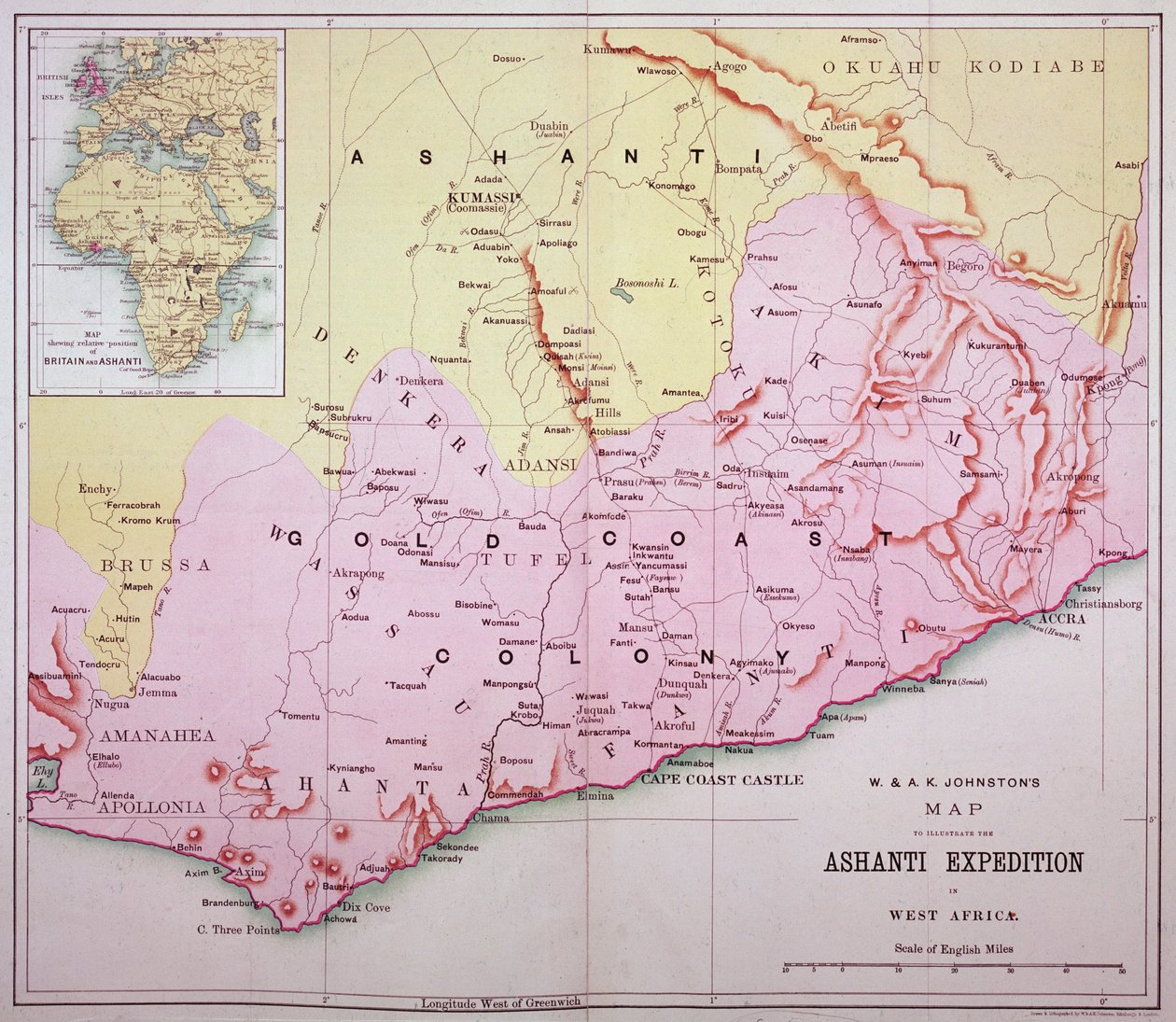
Map of the Gold Coast at the Time of the Third Ashanti Expedition in 1874 by Unbekannt Unbekannt

Map of the Gold Coast at the Time of the Third Ashanti Expedition in 1874

(Map of the Gold Coast at the time of the Third Ashanti Expedition in 1874 )


Unbekannt Unbekannt

€ 107.05
Enthält 0% MwSt.
   Configure art print
Undated  ·  colour lithograph  ·  Picture ID: 75859

Nonclassified artists  ·  Cartography

Map of the Gold Coast at the Time of the Third Ashanti Expedition in 1874 by Unbekannt Unbekannt. Available as an art print on canvas, photo paper, watercolor board, uncoated paper or Japanese paper.
west africa · africa · west african · african · colonialism · imperialism · invasion · aggression · colony · empire · ghana · Private Collection / Bridgeman Images
AR/3D   View in 3D / AR zu Favoriten hinzufügen   Add to favorites    Select wall color    View painting in a room
0 Reviews

Configure art print

Picture Frame

Medium & Stretcher

Glass & Passepartout

Miscellaneous & Extras

 Save / compare configuration
Preview Icon

Summary

Gemälde
Veredelung
Keilrahmen
Museumslizenz

€ 107.05
(inkl. 20% MwSt)
   Add to cart

Bildschärfe: PERFEKT

Should you desire adjustments to brightness and color, or a custom crop of the motif, we are happy to make these changes at no additional cost to you. Please do not hesitate to contact us.

Similar artworks selected for you

Map of South Africa, c1914, c1920 The Middle East in the mid 19th century, from Coltons General Atlas, edition of 1857 The Southern Portion of Rajpootana, 1820 Map of Western India, 1816 Map of the Theatre of the War in the Transvaal France and Belgium for the campaign of 1814-1815 - engraving in Bombay Presidency, 1890 Wyld Map of Central Africa, 1902 Map of Austria-Hungary Map of Kutch and Runn, India, 1854 Map of Bengal, the North West and Central Provinces, and Assam, 1902 Map of the Italian Fighting Front, 1919 Map of South Africa Map of India, published under the direction of Colonel H.R. Thuillier, R.E., Surveyor General of India, 1877 Countries between Egypt and Canaan Bacon’s Large-Scale Map of the Transvaal Orange Free State and Natal with extension south to Port Elizabeth, South Africa Map of South Africa Illustrating Dr. Livingstone 1899 map of South Africa during Second Boer War Map of the Seat of War in South Africa Panorama of French Africa, Map of French Expeditions in Africa. Engraving in Map of the Kingdom of Hungary (etching) Map of Africa according to the Franco-English Convention - in Map of German South West Africa, First World War Map of French expeditions in Africa, illustration from Le Petit Journal of March 5 Map of the Barbary States, 1902 Map of Africa Map of the Crimea Map of South Southern Africa
Show more similar artworks

Other art prints by Unbekannt Unbekannt

Lascaux Cave Painting, Bordeaux, France Wall painting of a bird in a garden, Pompeii, 1st century AD Oscar Wilde and Lord Alfred Douglas Garden Paintings from the so-called Villa of Livia, Primaporta, Rome, c.20 BC Archer, cave painting, Tassili n Death comes for the Unbelieving Woman, from Guhyasamaja, Akshobhyavajra Bison Painting in Altamira caves, Upper Paleolithic museum, Santander, Cantabria, Spain Night Parade of a Hundred Demons Examples of Ionic and Corinthian orders in Greek architecture, from The National Encyclopaedia, published c.1890 Detail of Italy from the Peutinger map (detail) The Unicorn in Captivity Sidewall View of Milan Cathedral The unbroken seal on Tutankhamun
Discover more works by Unbekannt Unbekannt

Other motives from the category Cartography

Part of the Tabula Peutingeriana, an illustrated itinerarium of the road network in the Roman Empire. Detail of Italy from the Peutinger map copy Map of the World, 1486 Map of the Great Lakes Map of the United States in 1803, from Our Whole Country: The Past and Present of the United States, Historical and Descriptive, by John Warner Barber and Henry Hare, 1861 Chart showing the sea coast of England and Wales, plate from Map of Palestine, Palestina Antiqua, from Map of Naples, c.1600 Map of Laputa (flying island top right) and Balnibarbii (main port Maldonada) from Part III: A Voyage to Laputa, Balnibarbi, Luggnagg, Glubbdubdrib, and Japan in Gulliver Map of Sixteenth Century Europe, from the Map showing the localities of the Indian tribes of the US in 1833, illustration from Map of the Holy Land A Sailing Ship Firing Its Cannon, Detail from a Map of the Pacific, China and America, 1599 Map of Africa, Published in 1700, Paris Map of Palmanova, from Les Villes de Venetie, 1704, published by Rutgert Alberts in the Hague Map of Tenochtitlan and the Gulf of Mexico, from Praeclara Ferdinadi Cortesii de Nova maris Oceani Hyspania Narratio by Hernando Cortes (1485-1547) 1524
View More from "Cartography"

Excerpt from our top sellers

Star of the Hero Polyphonically Painted White Villa by the Sea The Entrance to the Grand Canal, Venice, ca 1730 Boreas, 1903 View of El Castillo, 1844 Starry Night, c.1850-65 The Typewriter of Julio Antonio Mella, Mexico City, 1928 Yacht Approaching the Coast Paradiso, Canto 31: The saintly throng form a rose in the empyrean The Monk by the Sea, 1808-1810 The Kiss Return of the Prodigal Son Cosy Corner The Gate of the Great Umayyad Mosque, Damascus
Show More Artworks


What our customers think about us


Frequently Asked Questions about Meisterdrucke


Personalizing your art print at Meisterdrucke is a simple and intuitive process that allows you to design an artwork exactly to your specifications: Choose a frame, determine the image size, decide on a printing medium, and add suitable glazing or a stretcher frame. We also offer customization options such as mats, fillets, and spacers. Our customer service is available to help you design your perfect artwork.

At Meisterdrucke, you have the fascinating option to visualize the artwork you configured directly in your own space. For a tailored preview, simply upload a photo of your room and let the artwork appear on it. If you visit us via a mobile device, be it a phone or tablet, our augmented reality feature brings the image to life and seamlessly projects it into your space. An experience that uniquely combines art and technology.

Choosing the medium is often a matter of personal taste. To give you a clearer idea, we have provided some images for each medium. For a holistic experience, we also offer you a sample set of all paper variants so you can make a decision not just visually but also haptically. You can take advantage of the sample set free of charge – only the shipping costs will apply. You can order the sample set directly.

Do not worry. At Meisterdrucke, we do not proceed mechanically. We manually review each order. If there are any inconsistencies or peculiarities in the configuration, we will immediately contact you. Of course, our courteous and patient support is always at your side to assist you with the configuration. Together with you, we adjust your image by phone or email so that the final result exactly meets your expectations.


Do you have any questions?

Are you interested in an art print from our manufactory but still unsure? Do you need advice on choosing the medium or help with the order?

Our experts are happy to assist you.

+43 4257 29415
support@meisterdrucke.com
Mo-Do: 7:00 - 16:00 | Fr: 7:00 - 13:00

Do you have any questions?

Are you interested in an art print from our manufactory but still unsure? Do you need advice on choosing the medium or help with the order?

Our experts are happy to assist you.

+43 4257 29415
support@meisterdrucke.com
Mo-Do: 7:00 - 16:00 | Fr: 7:00 - 13:00


Meisterdrucke

   Kärntner Strasse 46
        9586 Finkenstein am Faaker See
        Austria
        +43 4257 29415
        support@meisterdrucke.com
Other languages

                   
Erfahrungen & Bewertungen zu Meisterdrucke
Post.at DHL Express Quehenberger Cargoboard
Kaiser Franz Joseph

Meisterdrucke
Kärntner Strasse 46
9586 Finkenstein am Faaker See · Austria
+43 4257 29415 · office@meisterdrucke.com
Post.at DHL Express Quehenberger Cargoboard


Meisterdrucke 2716 Bewertungen auf ProvenExpert.com

(c) 2025 meisterdrucke.us