Search by artist, work title or style – e.g. Monet, Starry Night, Impressionism, Hokusai wave, nude. Describe the scene – e.g. green meadow, abstract with lots of red, dark oil painting, standing nude next to a tree.

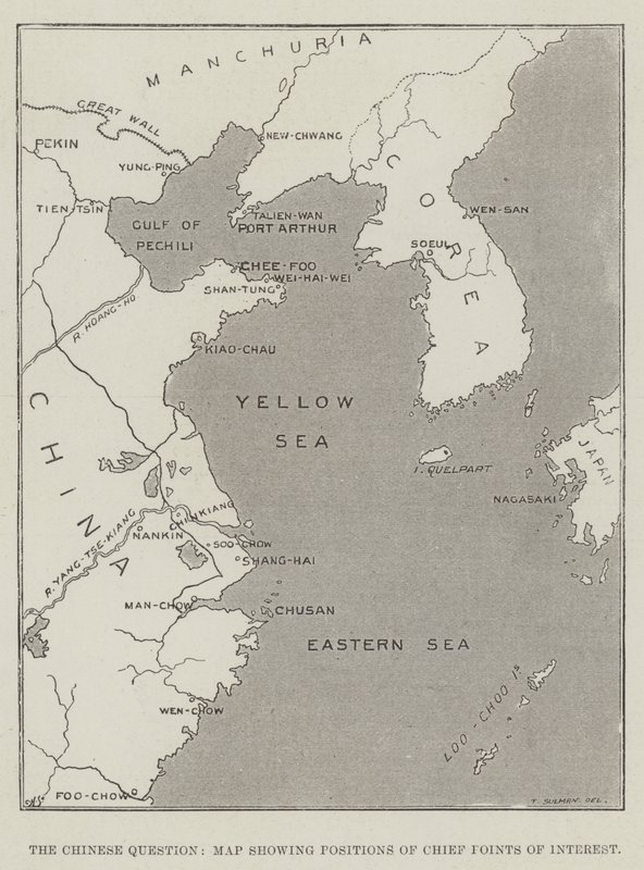
The Chinese Question, Map Showing Positions of Chief Points of Interest by Thomas Sulman

The Chinese Question, Map Showing Positions of Chief Points of Interest

(The Chinese Question, Map showing Positions of Chief Points of Interest )


Thomas Sulman

€ 119.25
Enthält 0% MwSt.
   Configure art print
1898  ·  Gravur  ·  Picture ID: 164856

Illustration  ·  Cartography

The Chinese Question, Map Showing Positions of Chief Points of Interest by Thomas Sulman. Available as an art print on canvas, photo paper, watercolor board, uncoated paper or Japanese paper.
chinese question · showing · positions · chief points of interest · china · Maps · Private Collection / Bridgeman Images · / Look and Learn
AR/3D   View in 3D / AR zu Favoriten hinzufügen   Add to favorites    Select wall color    View painting in a room
0 Reviews

Configure art print

Picture Frame

Medium & Stretcher

Glass & Passepartout

Miscellaneous & Extras

 Save / compare configuration
Preview Icon

Summary

Gemälde
Veredelung
Keilrahmen
Museumslizenz

€ 119.25
(inkl. 20% MwSt)
   Add to cart

Bildschärfe: PERFEKT

Should you desire adjustments to brightness and color, or a custom crop of the motif, we are happy to make these changes at no additional cost to you. Please do not hesitate to contact us.

Similar artworks selected for you

The Chinese Crisis, Positions of Port Arthur and Kiau-Chiau, Occupied by Russia and Germany, with Names of Treaty Ports and Towns Underlined China: Sketch-map of China Map of the Baltic Sea Map of North-East China, Showing the Gulf of Pechili, the Tien-Tsin (Peiho) River, and the Approaches to Pekin England and France Map of China Atlantis: a map showing the location of the mythical continent, c1882 1956 Map of the Theatre of the War in China, 1900 Map of Melanesia Geographic map of Denmark in 1861, with the Duchies of Schleswig, Holstein and Lauenburg (engraving in British Isles, Principal Convalescent Resorts Map of the Strait of Malacca Hong Kong England after the Treaty of Wedmore 878 Ancient Italy Map of the Gallipoli Peninsula Battle of Manila Bay, Philippines, Spanish-American War Map Including Attica, with Salamis and Aegina, Boeotia, Megaris, and Part of Corinthia and Argolis Locality of the late Great Meteor Chart of the Arctic Regions Showing the North West Passage Connecting the Atlantic and Pacific Oceans Commercial Map of the African Continent England after the English conquest 700 Winds and Rainfall - May to October Chart of the Sea of Azoff and the Straits of Kertch and Yenikale Marco Polo The Gulf Stream Map showing how railways in England follow the low ground as much as possible Map of the Proposed Route to China from British Burmah Constantinople and the Bosphorus, c.1850
Show more similar artworks

Other art prints by Thomas Sulman

View of London from St Paul Advertisement, Messers John Brinsmead and Sons Advertisement, Hedges and Butler Advertisement, Marshall and Snelgrove The Chinese Crisis, Positions of Port Arthur and Kiau-Chiau, Occupied by Russia and Germany, with Names of Treaty Ports and Towns Underlined The Oxford and Cambridge Boat-Race, the Oxford Crew The Chinese Question, Map Showing Positions of Chief Points of Interest The International Fisheries Exhibition, General View of the Exhibition Buildings at South Kensington Furniture, Picture, Glass and China, Bronze, and Lamp Departments of Messers Silber and Fleming The International Health Exhibition, Tinned Provisions, Army and Navy Rations The Hamilton Palace Sale at Messers Christie and Mansion Newcastle upon Tyne, Illustration from The International Fisheries Exhibition; A General View of the Exhibition Buildings Ruins of the Fire at Kingston, Jamaica Advertisement, Max Greger
Discover more works by Thomas Sulman

Other motives from the category Cartography

Map of Jerusalem and the Surrounding Area World Map with Jerusalem in the Centre (from West Coast of Africa, from Lisbon to Sierra Leone, from A Map of The King Indian Campaign of 1832: Map of the Country Map of the Battle of Fere Champenoise and the Battle of Arcis-Sur-Aube, published by William Blackwood and Sons, Edinburgh and London, 1848 Map of Tenochtitlan and the Gulf of Mexico, from Praeclara Ferdinadi Cortesii de Nova maris Oceani Hyspania Narratio by Hernando Cortes (1485-1547) 1524 Map of South America, published in 1700, Paris Map of the world with possessions of the British Empire coloured red, c.1870 Geographic Map of the Azores The Indian Ocean, from an Atlas of the World in 33 Maps, Venice Map of the Holy Land, published in Amsterdam, 1629 Map of Eastern North America: Florida to Chesapeake Bay Map of the Northern Sky with Representations of the Constellations Map of the Atlantic Ocean, c.1550
View More from "Cartography"

Excerpt from our top sellers

Woman in Tehuantepec, Mexico The Geese Christ Pantocrator The Sun View of Arles with Irises in the Foreground Beach Study Vesuvius in Eruption Animals in a Landscape Reclining Nude Woman Reading a Book A Stroll on the Beach Philosophy Appian Way Landscape with Church and Path Stag Beetle Striped Jug with Spring Flowers, 1992
Show More Artworks


What our customers think about us


Frequently Asked Questions about Meisterdrucke


Personalizing your art print at Meisterdrucke is a simple and intuitive process that allows you to design an artwork exactly to your specifications: Choose a frame, determine the image size, decide on a printing medium, and add suitable glazing or a stretcher frame. We also offer customization options such as mats, fillets, and spacers. Our customer service is available to help you design your perfect artwork.

At Meisterdrucke, you have the fascinating option to visualize the artwork you configured directly in your own space. For a tailored preview, simply upload a photo of your room and let the artwork appear on it. If you visit us via a mobile device, be it a phone or tablet, our augmented reality feature brings the image to life and seamlessly projects it into your space. An experience that uniquely combines art and technology.

Choosing the medium is often a matter of personal taste. To give you a clearer idea, we have provided some images for each medium. For a holistic experience, we also offer you a sample set of all paper variants so you can make a decision not just visually but also haptically. You can take advantage of the sample set free of charge – only the shipping costs will apply. You can order the sample set directly.

Do not worry. At Meisterdrucke, we do not proceed mechanically. We manually review each order. If there are any inconsistencies or peculiarities in the configuration, we will immediately contact you. Of course, our courteous and patient support is always at your side to assist you with the configuration. Together with you, we adjust your image by phone or email so that the final result exactly meets your expectations.


Do you have any questions?

Are you interested in an art print from our manufactory but still unsure? Do you need advice on choosing the medium or help with the order?

Our experts are happy to assist you.

+43 4257 29415
support@meisterdrucke.com
Mo-Do: 7:00 - 16:00 | Fr: 7:00 - 13:00

Do you have any questions?

Are you interested in an art print from our manufactory but still unsure? Do you need advice on choosing the medium or help with the order?

Our experts are happy to assist you.

+43 4257 29415
support@meisterdrucke.com
Mo-Do: 7:00 - 16:00 | Fr: 7:00 - 13:00


Meisterdrucke

   Kärntner Strasse 46
        9586 Finkenstein am Faaker See
        Austria
        +43 4257 29415
        support@meisterdrucke.com
Other languages

                   
Erfahrungen & Bewertungen zu Meisterdrucke
Post.at DHL Express Quehenberger Cargoboard
Kaiser Franz Joseph

Meisterdrucke
Kärntner Strasse 46
9586 Finkenstein am Faaker See · Austria
+43 4257 29415 · office@meisterdrucke.com
Post.at DHL Express Quehenberger Cargoboard


Meisterdrucke 2746 Bewertungen auf ProvenExpert.com

(c) 2025 meisterdrucke.us