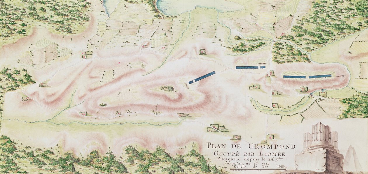
Map of Crompond, from

Map of Crompond, from 'Guerre de l'Amerique', 1782

(Map of Crompond, from 'Guerre de l'Amerique', 1782 (colour engraving))


F. Dubourg

€ 97.68
Enthält 0% MwSt.
   Configure art print
1782  ·  colour engraving  ·  Picture ID: 37348

Nonclassified artists  ·  Cartography

Map of Crompond, from 'Guerre de l'Amerique', 1782 by F. Dubourg. Available as an art print on canvas, photo paper, watercolor board, uncoated paper or Japanese paper.
Service Historique de la Marine, Vincennes, France / Bridgeman Images
AR/3D   View in 3D / AR zu Favoriten hinzufügen   Add to favorites    Select wall color    View painting in a room
0 Reviews

Configure art print

Picture Frame

Medium & Stretcher

Glass & Passepartout

Miscellaneous & Extras

 Save / compare configuration
Preview Icon

Summary

Gemälde
Veredelung
Keilrahmen
Museumslizenz

€ 97.68
(inkl. 20% MwSt)
   Add to cart

Bildschärfe: PERFEKT

Should you desire adjustments to brightness and color, or a custom crop of the motif, we are happy to make these changes at no additional cost to you. Please do not hesitate to contact us.

Similar artworks selected for you

Map of Phillipsburg, from Map of Rhode Island at the time of its occupation 1780-81 by the French Army on the orders of Jean-Baptiste de Vimeur Count of Rochambeau Entrenched Position of the 3rd Corps at Harrison Map of Rhode Island, from Map of Friderichstad and Its Situation Map of the Siege of York in 1781, from Map Depicting the Destruction of the Spanish Colony of St. Augustine in Florida on 7th July 1586 by the English Fleet Commanded by Sir Francis Drake A Coloured Plan, or Bird Plan of the city of Troy, from Plan of events at the Battle of Gunzburg between Austrian and French Troops in 1805, 1808 Chart of Kinsale A Plan of the Town, Harbour and Fortifications of Porto Bello, as it appears since it was taken by Adm: Vernon, 1742 Talke - Clough Hall Speculum Romanae Magnificentiae: Ancient Rome, and its Hills, from the West, 1582 Plan of the Island of Love in Gatchina Park Plan of the Battle of Mollwitz on the 10th April, 1741 Plan of the Battle of Blenheim Namur, from Atlas de Louis XIV. Plans des places etrangeres, 1665 Chart of the Battle off Cherbourg Peterhof, Russia: Elevation of the English Palace and plan of the park Plan of Granville, for Year IV of the Republic (1796) Map of Cochin, India Plan of the Battle of Culloden Map of the country of Lourdes in 1858, year of Bernadette Soubirous Plan of the Position of the Army under the command of Lieut. Genl. Burgoyne near Still Water, in which it encamped on 20th September 1777 Plan of Orwell Haven by Richard Lee Disposition of British Troops, with Fortifications North of Fort Knipehausen to Fort Independence A Geometrical Plan of the Ruined City of Palmyra, 1753 Plan of the Battle of Kunersdorf, August 12th, 1759
Show more similar artworks

Other art prints by F. Dubourg

Map of Rhode Island, from Map of Fisk-Kill and the Position of the French Army Reconnaissance of King Map of the Siege of York in 1781, from Map of South West-Point, Virginia Map of Phillipsburg, from Reconnaissance of King Map of North West-Point, Virginia, from General map of the camps and marches of the army in America on the orders of Rochambeau (detail) Map of Crompond, from Front cover of the atlas Guerre de l General map of the camps and march of the army in America on the orders of Rochambeau, detail of the left side, from Guerre de l
Discover more works by F. Dubourg

Other motives from the category Cartography

Map of the Operations which led to the Capitulation of Ulm, published by William Blackwood and Sons, Edinburgh and London, 1848 Map of Bas Poitou, Pays d President Paul Kruger, General Piet Joubert and a Map of the Transvaal and Orange Free State Map of Persia Town Map of Cairo Map of The West Part of Barbary, c.1720 Map of Connecticut, from Map of the world, based on descriptions and co-ordinates given in The Dedication to Queen Elizabeth I from a Book of Maps of England and Wales by Christopher Saxton, Published 1579 Map of North America, showing the boundaries of the United States, Canada and the Spanish Possessions, according to the proposals of the Court of France in 1782, from Map Showing the Military Campaigns of Louis XIV in the Low Countries, from Atlas Géographique et Militaire, Published in Paris, 1763 Typus Orbis Terrarum, map of the world, from Ortelius Map of Lubeck and Hamburg, from Detail of Constantinople from the Peutinger Map (detail) Town Map of Constantinople, Turkey, c.1650
View More from "Cartography"

Excerpt from our top sellers

The Pink Peach Tree, 1888 The Harvest Sailboats on the Wannsee The Water Lily Pond, Evening Lilith Village Landscape in Morning Light The Wild Hunt of Odin Irises Summer The Scream Girl with Child Forest Winter, 1573 A Moonlit Lane. Two Lovers at a Gate Chalk Paths
Show More Artworks


What our customers think about us


Frequently Asked Questions about Meisterdrucke


Personalizing your art print at Meisterdrucke is a simple and intuitive process that allows you to design an artwork exactly to your specifications: Choose a frame, determine the image size, decide on a printing medium, and add suitable glazing or a stretcher frame. We also offer customization options such as mats, fillets, and spacers. Our customer service is available to help you design your perfect artwork.

At Meisterdrucke, you have the fascinating option to visualize the artwork you configured directly in your own space. For a tailored preview, simply upload a photo of your room and let the artwork appear on it. If you visit us via a mobile device, be it a phone or tablet, our augmented reality feature brings the image to life and seamlessly projects it into your space. An experience that uniquely combines art and technology.

Choosing the medium is often a matter of personal taste. To give you a clearer idea, we have provided some images for each medium. For a holistic experience, we also offer you a sample set of all paper variants so you can make a decision not just visually but also haptically. You can take advantage of the sample set free of charge – only the shipping costs will apply. You can order the sample set directly.

Do not worry. At Meisterdrucke, we do not proceed mechanically. We manually review each order. If there are any inconsistencies or peculiarities in the configuration, we will immediately contact you. Of course, our courteous and patient support is always at your side to assist you with the configuration. Together with you, we adjust your image by phone or email so that the final result exactly meets your expectations.


Do you have any questions?

Are you interested in an art print from our manufactory but still unsure? Do you need advice on choosing the medium or help with the order?

Our experts are happy to assist you.

+43 4257 29415
support@meisterdrucke.com
Mo-Do: 7:00 - 16:00 | Fr: 7:00 - 13:00

Do you have any questions?

Are you interested in an art print from our manufactory but still unsure? Do you need advice on choosing the medium or help with the order?

Our experts are happy to assist you.

+43 4257 29415
support@meisterdrucke.com
Mo-Do: 7:00 - 16:00 | Fr: 7:00 - 13:00


Meisterdrucke

   Kärntner Strasse 46
        9586 Finkenstein am Faaker See
        Austria
        +43 4257 29415
        support@meisterdrucke.com
Other languages

                   
Erfahrungen & Bewertungen zu Meisterdrucke
Post.at DHL Express Quehenberger Cargoboard
Kaiser Franz Joseph

Meisterdrucke
Kärntner Strasse 46
9586 Finkenstein am Faaker See · Austria
+43 4257 29415 · office@meisterdrucke.com
Post.at DHL Express Quehenberger Cargoboard


Meisterdrucke 2707 Bewertungen auf ProvenExpert.com

(c) 2025 meisterdrucke.us