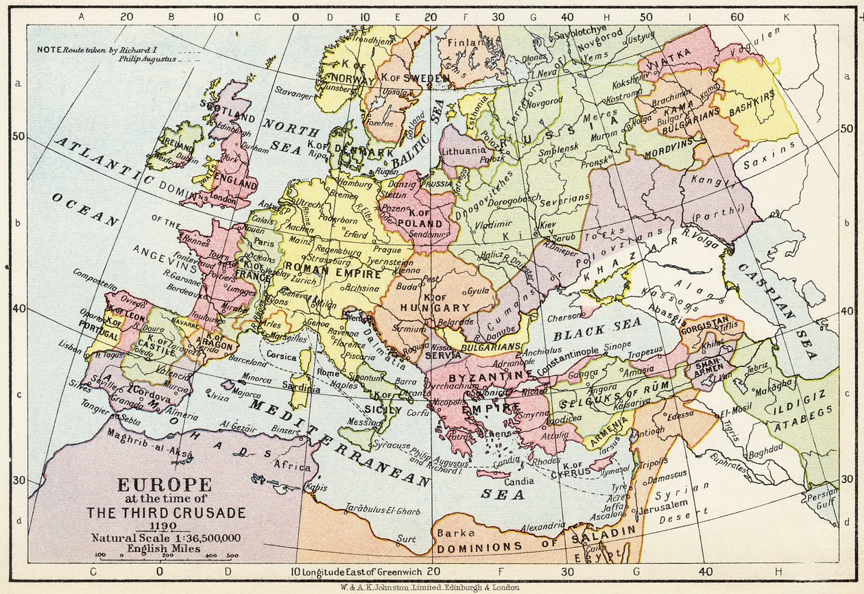
Map of Europe at the Time of the Third Crusade, 1190, from

Map of Europe at the Time of the Third Crusade, 1190, from 'Historical Atlas'

(Map of Europe at the time of the Third Crusade, 1190, from 'Historical Atlas', published by W. und A.K. Johnston Limited, 1911 )


English School

€ 122.36
Enthält 0% MwSt.
   Configure art print
1911  ·  colour lithograph  ·  Picture ID: 51646

Cultural Circles  ·  Cartography

Map of Europe at the Time of the Third Crusade, 1190, from 'Historical Atlas' by English School. Available as an art print on canvas, photo paper, watercolor board, uncoated paper or Japanese paper.
historical map · c12th · medieval · holy war · crusades · european · holy roman empire · byzantine empire · cartography · Private Collection / Bridgeman Images
Other color variations of this picture  
AR/3D   View in 3D / AR zu Favoriten hinzufügen   Add to favorites    Select wall color    View painting in a room
0 Reviews

Configure art print

Picture Frame

Medium & Stretcher

Glass & Passepartout

Miscellaneous & Extras

 Save / compare configuration
Preview Icon

Summary

Gemälde
Veredelung
Keilrahmen
Museumslizenz

€ 122.36
(inkl. 20% MwSt)
   Add to cart

Bildschärfe: PERFEKT

Should you desire adjustments to brightness and color, or a custom crop of the motif, we are happy to make these changes at no additional cost to you. Please do not hesitate to contact us.

Similar artworks selected for you

Map of Europe after the Peace of Tilsit in 1807, from Map of Europe in 1910 Europe in 814 - Empires of the West and the East - Plate extracted from Map of Central Europe European States in 1792 Europe Map of the Extent of the Hanseatic League Map of the Extent of the Hanseatic League in About 1400 Atlas of Europe in 814: Empires of the West and the East. From Central Europe and the Mediterranean Central Europe in 1812 The Empire of Charlemagne, from Atlas Historique et Pittoresque, by M J-H Schnitzler, 1857 Europe and the Orient at the time of the 3rd Great Crusade at the end of the 13th century - Map prepared by M J-H Schnitzler, Historical and Picturesque Atlas 1858 Map of Europe Roman Empire in Its Greatest Extent Europe, Historical Central Europe showing the historic sites and battlefields of 1792-1813 - engraving in Europe during the time of the Crusades Map of Europe, Showing Density of Population Europe After the Invasion of the Barbarians in the 6th Century - Plate Extracted from Geographic map of Europe at the time of Napoleon I. In Map of Central Europe and the Mediterranean, from Countries Travelled by the Apostles and Showing the Journeys of St. Paul Between Asia and Europe Geographic Map of Europe in the 1870s Europe, from Map of the Caliphate Empire in 750, from Europe in early postglacial times Volkerkarte von Russland. 1881 A
Show more similar artworks

Other art prints by English School

The Nonpareil with Portraits of Queen Victoria and Prince Albert Church and Cottage with Lighted Windows Woman beating her husband with a shoe Portrait of a bodybuilder The Great Green Tree Frog Roman Augurs Homeric Table, the Shield of Achilles, designed by John Henning, Junior, Esquire View of the Acropolis of Athens Lavater Lee and Sons, acrobats Elephant (engraving) Princes Street Edinburgh - West End English Rose Ships Arriving English Rose
Discover more works by English School

Other motives from the category Cartography

Detail from a Renaissance map of Europe, Jacopo Russo (after) 1528 Map of the Countries of the Persian Gulf, from the Map of Antwerp Map of Charles V, Map of Mecia de Viladestes, a portulan of Europe and North Africa, 1413 Map of the Battle of Wagram, published by William Blackwood and Sons, Edinburgh and London, 1848 Map of the Western Mediterranean Map of the North Sea, c.1675 Map of the Russian Empire, 1588 Map of Szolnok, from Map of Ancient Egypt Map of Brazil, from Dutch Marine Maps, 1637 Typus Orbis Terrarum, map of the world, from Ortelius Map of the New Simplon Pass, 1803 Map of Asia, Tartaria, Japan, the Philippines and the East Indies, engraved by G. van Gouwen, c.1690 Detail of Italy from the Peutinger map (detail)
View More from "Cartography"

Excerpt from our top sellers

The Gate of the Great Umayyad Mosque, Damascus Still Life with Coffee The Interior of the Palm House Fish Magic White Waterlilies Starry Night, c.1850-65 Striped Jug with Spring Flowers, 1992 Stein on the Danube (District of Krems) The Singing Man Poppies Childhood Friends The Attic Room Meadows near Greifswald The Creation of the World Representing the Cosmic Sphere of the Earth (Back Panels of the Triptych The Plain of Auvers
Show More Artworks


What our customers think about us


Frequently Asked Questions about Meisterdrucke


Personalizing your art print at Meisterdrucke is a simple and intuitive process that allows you to design an artwork exactly to your specifications: Choose a frame, determine the image size, decide on a printing medium, and add suitable glazing or a stretcher frame. We also offer customization options such as mats, fillets, and spacers. Our customer service is available to help you design your perfect artwork.

At Meisterdrucke, you have the fascinating option to visualize the artwork you configured directly in your own space. For a tailored preview, simply upload a photo of your room and let the artwork appear on it. If you visit us via a mobile device, be it a phone or tablet, our augmented reality feature brings the image to life and seamlessly projects it into your space. An experience that uniquely combines art and technology.

Choosing the medium is often a matter of personal taste. To give you a clearer idea, we have provided some images for each medium. For a holistic experience, we also offer you a sample set of all paper variants so you can make a decision not just visually but also haptically. You can take advantage of the sample set free of charge – only the shipping costs will apply. You can order the sample set directly.

Do not worry. At Meisterdrucke, we do not proceed mechanically. We manually review each order. If there are any inconsistencies or peculiarities in the configuration, we will immediately contact you. Of course, our courteous and patient support is always at your side to assist you with the configuration. Together with you, we adjust your image by phone or email so that the final result exactly meets your expectations.


Do you have any questions?

Are you interested in an art print from our manufactory but still unsure? Do you need advice on choosing the medium or help with the order?

Our experts are happy to assist you.

+43 4257 29415
support@meisterdrucke.com
Mo-Do: 7:00 - 16:00 | Fr: 7:00 - 13:00

Do you have any questions?

Are you interested in an art print from our manufactory but still unsure? Do you need advice on choosing the medium or help with the order?

Our experts are happy to assist you.

+43 4257 29415
support@meisterdrucke.com
Mo-Do: 7:00 - 16:00 | Fr: 7:00 - 13:00


Meisterdrucke

   Kärntner Strasse 46
        9586 Finkenstein am Faaker See
        Austria
        +43 4257 29415
        support@meisterdrucke.com
Other languages

                   
Erfahrungen & Bewertungen zu Meisterdrucke
Post.at DHL Express Quehenberger Cargoboard
Kaiser Franz Joseph

Meisterdrucke
Kärntner Strasse 46
9586 Finkenstein am Faaker See · Austria
+43 4257 29415 · office@meisterdrucke.com
Post.at DHL Express Quehenberger Cargoboard


Meisterdrucke 2716 Bewertungen auf ProvenExpert.com

(c) 2025 meisterdrucke.us